


NHC Graphical Outlook Archive
« Earliest Available ‹ Earlier Later › Latest Available »
Place your mouse cursor over areas of interest for more information
| GIS data: .shp |
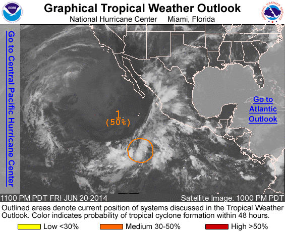
ZCZC MIATWOEP ALL
TTAA00 KNHC DDHHMM

TROPICAL WEATHER OUTLOOK
NWS NATIONAL HURRICANE CENTER MIAMI FL
1100 PM PDT FRI JUN 20 2014

For the eastern North Pacific...east of 140 degrees west longitude:

1. Shower and thunderstorm activity has changed little during the past
several hours in association with a nearly stationary low pressure
system located about 725 miles south-southwest of Manzanillo,
Mexico.  Although upper-level winds are favorable, proximity to
dry, stable air in the northwestern portion of the low could inhibit
significant development of this disturbance. Upper-level winds are
expected to become less conducive on Sunday for tropical cyclone
formation to occur while the system moves northward at 5 to 10 mph.
* Formation chance through 48 hours...medium...50 percent.
* Formation chance through 5 days...medium...50 percent.

Forecaster Stewart
List of all Atlantic Outlooks
List of all East Pacific Outlooks