


NHC Graphical Outlook Archive
« Earliest Available ‹ Earlier Later › Latest Available »
Place your mouse cursor over areas of interest for more information
| GIS data: .shp |
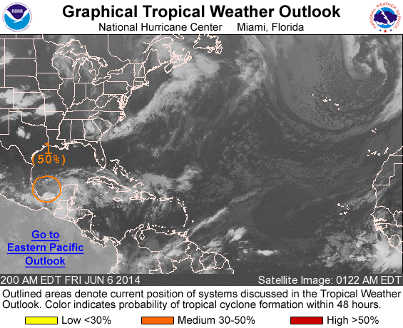
ZCZC MIATWOAT ALL
TTAA00 KNHC DDHHMM

TROPICAL WEATHER OUTLOOK
NWS NATIONAL HURRICANE CENTER MIAMI FL
200 AM EDT FRI JUN 6 2014

For the North Atlantic...Caribbean Sea and the Gulf of Mexico:

1. Thunderstorm activity has increased slightly near the center of a
stationary low pressure system located over the southern Bay of
Campeche. Unfavorable upper-level winds are forecast to subside
somewhat during the next day or so, and gradual development of
this disturbance could occur later today before environmental
conditions become hostile again on Saturday. An Air Force Reserve
reconnaissance aircraft is scheduled to investigate the system this
afternoon, if necessary. Regardless of development, this disturbance
will continue to produce extremely heavy rains, along with
life-threatening flash floods and mud slides, over portions of
southeastern Mexico during the next few days.
* Formation chance through 48 hours...medium...50 percent.
* Formation chance through 5 days...medium...50 percent.

Forecaster Stewart
List of all Atlantic Outlooks
List of all East Pacific Outlooks