


NHC Graphical Outlook Archive
« Earliest Available ‹ Earlier Later › Latest Available »
Place your mouse cursor over areas of interest for more information
| GIS data: .shp |
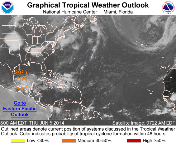
ZCZC MIATWOAT ALL
TTAA00 KNHC DDHHMM

TROPICAL WEATHER OUTLOOK
NWS NATIONAL HURRICANE CENTER MIAMI FL
800 AM EDT THU JUN 5 2014

For the North Atlantic...Caribbean Sea and the Gulf of Mexico:

1. Showers and thunderstorms have recently increased near a low
pressure area over the southern Bay of Campeche.  Despite strong
upper-level winds, some further development of this system is
possible over the next day or two if the low remains offshore of
eastern Mexico.  An Air Force Reserve Hurricane Hunter aircraft is
scheduled to investigate this system this afternoon, if necessary.
This disturbance has the potential to produce extremely heavy rains
and life-threatening flash floods and mud slides over portions of
southeastern Mexico during the next few days.
* Formation chance through 48 hours...medium...30 percent.
* Formation chance through 5 days...medium...30 percent.

Forecaster Blake
List of all Atlantic Outlooks
List of all East Pacific Outlooks