


NHC Graphical Outlook Archive
« Earliest Available ‹ Earlier Later › Latest Available »
Place your mouse cursor over areas of interest for more information
| GIS data: .shp |
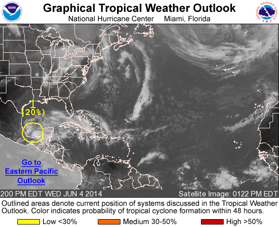
ZCZC MIATWOAT ALL
TTAA00 KNHC DDHHMM

TROPICAL WEATHER OUTLOOK
NWS NATIONAL HURRICANE CENTER MIAMI FL
200 PM EDT WED JUN 4 2014

For the North Atlantic...Caribbean Sea and the Gulf of Mexico:

1. A complex low pressure area centered over the southern Bay of
Campeche is producing disorganized showers and thunderstorms over a
large portion of the southwestern Gulf of Mexico and southeastern
Mexico. Strong upper-level winds will likely inhibit significant
development of this system during the next couple of days before it
moves inland over eastern Mexico by Saturday. However, this
disturbance has the potential to produce extremely heavy rains and
life-threatening flash floods and mudslides during the next few days
over portions of southeastern Mexico.
* Formation chance through 48 hours...low...20 percent
* Formation chance through 5 days...low...20 percent

Forecaster Blake
List of all Atlantic Outlooks
List of all East Pacific Outlooks