Skip Navigation Links
National Oceanic and Atmospheric Administration logo National Weather Service logo United States Department of Commerce

Marine Graphical Composite Forecast Map for Caribbean Offshore Waters


Click here to return to the main marine page

Step Between Times
map n/amap n/amap n/amap n/amap n/amap n/amap n/amap n/amap n/amap n/amap n/amap n/amap n/amap n/amap n/amap n/a

https://www.hurricanes.gov/marine/forecast

AMZ001-220200-
Synopsis for Caribbean Sea, and Tropical N Atlantic from 07N to
19N W of 55W
859 AM EST Sat Feb 21 2026

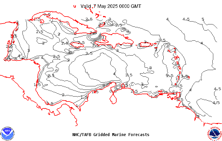
.SYNOPSIS...The pressure gradient between an Atlantic ridge
along 25N and the Colombian low will support fresh to strong 
trade winds in the Gulf of Honduras through tonight and across 
the south-central Caribbean through Sun, before diminishing. Winds
will reach near-gale force tonight offshore of Colombia. Moderate
to occasionally fresh trade winds are expected for the rest of 
the Caribbean through Sun night. Farther east, rough seas will 
linger E of the Lesser Antilles through tonight as N swell 
progresses across the central tropical Atlantic. A strong cold 
front will enter the northwestern Caribbean early Mon, then extend
from NW Haiti to near the Nicaragua-Costa Rica border Tue 
morning. Expect strong N winds and rapidly building seas behind 
this front.