895
AXNT20 KNHC 170948
TWDAT

Tropical Weather Discussion
NWS National Hurricane Center Miami FL
1215 UTC Fri Jul 17 2026

Tropical Weather Discussion for North America, Central America
Gulf of America, Caribbean Sea, northern sections of South
America, and Atlantic Ocean to the African coast from the
Equator to 31N. The following information is based on satellite
imagery, weather observations, radar and meteorological analysis.

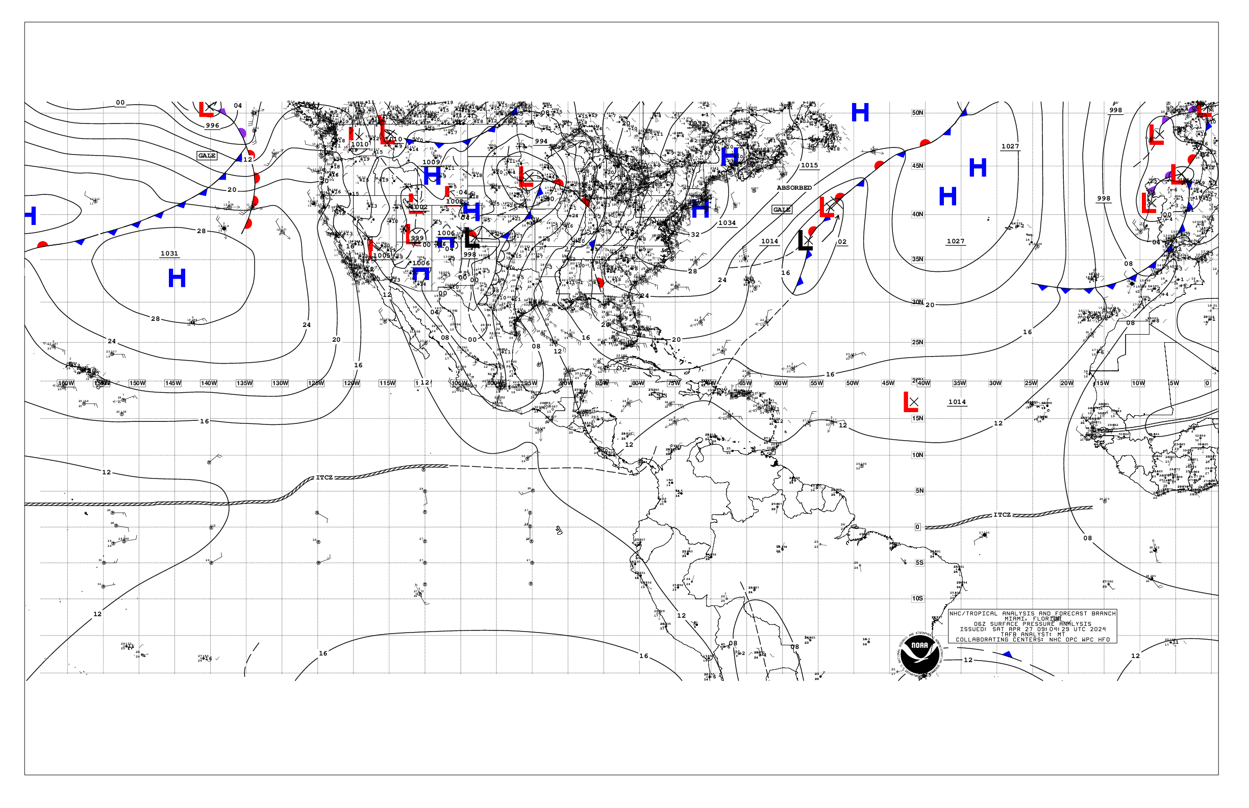
Based on 0600 UTC surface analysis and satellite imagery through
0900 UTC.

...SPECIAL FEATURE...

Caribbean Gale Warning: A tight pressure gradient between western
Atlantic high pressure north of the basin and the Colombian low
will support fresh to strong NE-E winds in the south-central
Caribbean during the next several days. Winds will pulse to gale-
force across the waters N of Colombia each night through Sat
night. Rough to very rough seas 12 to 14 ft will develop during
the times of peak winds.

Please read the latest HIGH SEAS FORECAST
issued by the National Hurricane Center at website -
https://www.nhc.noaa.gov/text/MIAHSFAT2.shtml for more details.

...TROPICAL WAVES...

An eastern Atlantic tropical wave is analyzed along 22W, south of
17N, moving westward at 5-10 kt. Overnight satellite imagery and
scatterometer data suggest a 1011 mb surface low is located
southeast of the Cabo Verde Islands near 13N22W. Scattered
moderate convection is present from 10.5N to 14.5N between 20W and
24W. Development of this system, if any, should be slow to occur
during the next day or so while it moves west- northwestward at 10
to 15 mph. By this weekend, the system is forecast to move into a
hostile environment, and further development is not expected. The
disturbance has a low chance of development over the next 7 days.

A central Atlantic tropical wave is along 40W, south of 17N,
moving westward at 15-20 kt. Widely scattered moderate convection
is noted along the ITCZ ahead of this wave.

...MONSOON TROUGH/ITCZ...

The monsoon trough enters the Atlantic through the coast of
Mauritania near 21N17W and continues southwestward to a 1011 mb
low pres near 13N22W to 09N39W. The ITCZ extends from 09N41W to
05.5N53W. Scattered moderate convection is present within 120 nm
on south of the monsoon trough and north of ITCZ to 10.5N between
41W and 59W.

...GULF OF AMERICA...

1022 mb high pressure is centered southeast and offshore of the
mouth of the Mississippi River, and is forcing fresh to locally
strong easterly winds south of 23N and between 84W and 95W, as
shown by recent satellite scatterometer data. Seas area 3 to 5 ft
across this area. Moderate to fresh E-SE winds are present in the
remainder of the western and SE Gulf waters, where seas are 2-4
ft. North of the high, gentle to moderate W to NW winds and 2 to 3
ft seas prevail. Elsewhere, slight to gentle winds and slight
seas prevail. Upper level low pressure across the southeast Gulf
is supporting a cluster of moderate to strong convection along the
W coast of Florida from Cape Coral to New Port Richey. Scattered
showers and isolated thunderstorms are also across the Mexican
coastal waters from Cabo Rojo to offshore of Veracruz.

For the forecast, high pressure will meander across the northern
Gulf through early Mon. Fresh to strong winds will pulse offshore
the Yucatan Peninsula each evening and night. Gentle to moderate
winds, and slight to moderate seas, will prevail elsewhere. Upper
level low pressure across the eastern Gulf will support active
thunderstorms across portions of the NE Gulf through Sun.

Looking ahead, an area of low pressure is forecast to form this
weekend over the northeastern Gulf of America. Some gradual
development of this system is possible while it meanders over the
northeastern Gulf or moves slowly northeastward toward the coast
of the southeastern United States early next week. The chance of
formation through the next 7 days is low.

...CARIBBEAN SEA...

A Gale Warning is in effect for the south-central Caribbean near
the coast of Colombia. Seas are estimated at 10 to 14 ft in the
area presently. Please refer to the Special Features section for
more details.

The Atlantic subtropical ridge persists along 26N-27N to the
north of the Caribbean Sea, forcing strong to gale easterly trade
winds across the central Caribbean, with the strongest winds
occurring off Colombia and in the Gulf of Venezuela. Rough to very
rough seas are found in these waters. Fresh to strong NE winds
and moderate seas are noted in the Windward Passage and Gulf of
Honduras. Meanwhile, moderate to fresh easterly winds and moderate
seas are present in the eastern Caribbean. Elsewhere, moderate or
weaker winds and slight to moderate seas are prevalent. A few
clusters of moderate convection across the waters east of the
Yucatan Peninsula and across the Channel.

For the forecast, the pressure gradient between the Atlantic high
pressure ridge, and the Colombian low, will support NE winds
pulsing to gale-force across the waters N of Colombia each night
through Sat night. Otherwise, strong to near-gale trade winds and
rough seas will prevail across the much of the central Caribbean
into early Mon before contracting to south of 15N Mon and Tue.
East winds will pulse fresh to locally strong each evening in the
Gulf of Honduras and Windward Passage.

...ATLANTIC OCEAN...

An extensive subtropical ridge persists across the tropical
Atlantic north of 15N, anchored by 1027 mb centered near 28N48W
and extends westward to southeast Florida. Saharan dust and mid-
latitude dry air continue to dominate the basin, suppressing the
development of showers and thunderstorms. Fresh to locally strong
easterly trade winds and moderate seas are occurring off the SE
Bahamas, Haiti and eastern Cuba. Moderate to locally fresh
easterly winds and moderate seas are prevalent south of 24N and
west of 30W to the Lesser Antilles. Widely scattered clusters of
moderate convection are noted from offshore of Cape Canaveral
northeastward toward Bermuda.

Meanwhile, in the far eastern Atlantic, fresh to locally strong
winds and seas of 5-7 ft are noted north of the monsoon trough
and east of 32W. Fresh to locally strong SW winds and seas of 5-8
ft are evident south of the monsoon trough and east of 26W.
Elsewhere, moderate or weaker winds and moderate seas prevail.

For the forecast west of 55W, the western Atlantic subtropical
ridge will drift slightly northward through Sun night, then
weaken early next week as a broad surface trough develops between
50W and 60W and shifts westward through mid week. This weather
pattern will support moderate to fresh trades south of 24N Sun
night, and gentle winds to the north. Pulsing strong winds are
expected each evening and night across the waters N of Hispaniola
and in the Windward Passage.

$$
Stripling


 NHC on Facebook
 NHC on X
 NHC on YouTube
 NHC Blog: