000
AXNT20 KNHC 302301
TWDAT

Tropical Weather Discussion
NWS National Hurricane Center Miami FL
0015 UTC Mon Aug 31 2026

Tropical Weather Discussion for North America, Central America
Gulf of America, Caribbean Sea, northern sections of South
America, and Atlantic Ocean to the African coast from the
Equator to 31N. The following information is based on satellite
imagery, weather observations, radar and meteorological analysis.

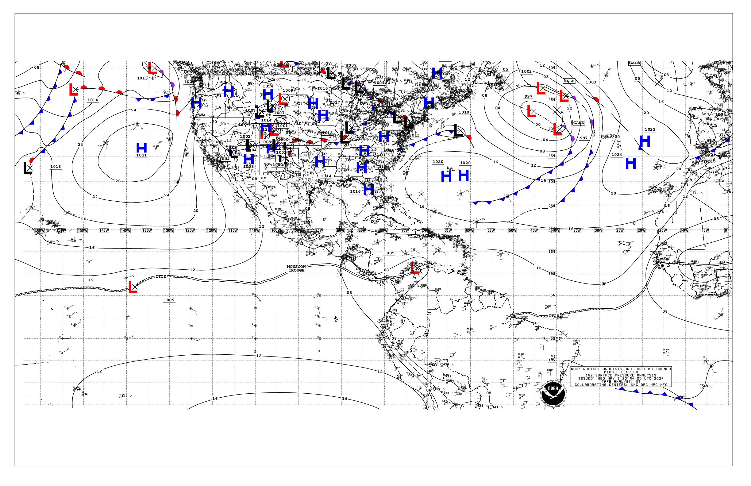
Based on 1800 UTC surface analysis and satellite imagery through
2300 UTC.

...SPECIAL FEATURES...

Northern Gulf of America (AL97):
A low pressure area is located over the northern Gulf of America
about 125 miles south of the coast of southeastern Louisiana.
satellite imagery and recent satellite wind data indicate that
this system has become better organized since yesterday.
Additional development is possible as the low moves slowly west-
northwestward, and a short-lived tropical depression or tropical
storm could form before the system reaches the Upper Texas or
southwestern Louisiana coasts Tuesday or Tuesday night. Interests
along the Louisiana and Upper Texas coasts should monitor the
progress of this system. Regardless of development, locally heavy
rainfall is possible over portions of the Upper Texas or
southwestern Louisiana coasts during the next couple of days.
this system has a medium chance of tropical cyclone formation
through 48 hours, and also through 7 days.

Near Puerto Rico and the Virgin Islands (Remnants of Dolly):
A strong tropical wave, the remnants of Tropical Storm Dolly, is
producing an area of showers and thunderstorms from Puerto Rico
eastward across the Virgin Islands and the northern Leeward
Islands. Satellite data and surface observations indicate that
there are no signs of a closed surface circulation, and
redevelopment is unlikely during the next day or two while the
wave moves westward to west-northwestward at about 25 mph. The
system should bring locally heavy rains and gusty winds to
portions of the Leeward Islands, the Virgin Islands, Puerto Rico,
and Hispaniola over the next couple of days. Conditions may
become more conducive for redevelopment by the middle of the week
as the system reaches the southeastern Gulf of America. Showers
and thunderstorms are currently affecting the Lesser Antilles
mainly north of St. Lucia, Puerto Rico and the US/UK Virgin
Islands and Dominican Republic. Rainfall amounts and the location
of the highest totals will vary from island to island, as local
topography will enhance orographic lift and support the heaviest
rainfall. Please refer to your local weather agency for specific
rainfall forecasts for your local area.

Please, refer to the latest NHC Tropical Weather Outlook at
www.hurricanes.gov for more details.

...TROPICAL WAVES...

A tropical wave is added to 1800 UTC analysis/surface map along
20W south of 20N. Some shower activity is near the wave axis.

Another tropical is along 42W, south of 21N, moving westward at
around 15 to 20 kt. Scattered moderate convection is noted where
the wave meets the ITCZ.

A strong tropical wave, the remnants of Tropical Storm Dolly, is
along 66W. Please, see the Special Features section for more
details.

Another tropical is over the central Caribbean with axis near
80W, south of 20N, moving westward near 20 kt. The wave appears
to enhance convection over the SW Caribbean, especially over
western Panama. A few showers are near the northern end of the
wave axis over the Cayman Islands.

...MONSOON TROUGH/ITCZ...

The monsoon trough enters the Atlantic from coastal Mauritania at
20N16W southwestward to 09N30W. The ITCZ begins there and
extends to 10N39W, then resumes at 09N43W and continues westward
to NE Venezuela at 08.5N60W. Scattered moderate convection is
occurring from 04N to 10N between 23W and 60W.

...GULF OF AMERICA...

A 1014 mb low pressure (AL97) about 100 NM south of the mouth of
the Mississippi River is producing scattered thunderstorms in
the north-central waters. Aside from gusty winds in thunderstorms,
peak winds are around 20 kt and seas 4 ft. Scatterometer data
indicate the cyclonic circulation of this system, and a closed
low is analyzed. Elsewhere, winds across the Gulf are moderate or
weaker with seas 1 to 3 ft.

For the forecast, additional development is possible as the above
mentioned low moves slowly west-northwest and a short-lived
tropical depression or tropical storm could form before the
system reaches the Upper Texas or SW Louisiana coasts Tue or Tue
night. Regardless of development, mariners over the north-central
and northwest Gulf can expect strong thunderstorms with gusty
winds and locally higher seas early this week. Elsewhere, weak
high pressure will persist through the forecast period, sustaining
moderate or weaker winds and slight seas. Winds will pulse to
fresh with moderate seas off western Yucatan during the evenings
due to a diurnal surface trough moving west off the peninsula
each night.

...CARIBBEAN SEA...

Please refer to the Special Features section above for rainfall
information associated with a strong tropical wave moving across
the NE Caribbean.

The pressure gradient from the Bermuda High north of the area
along with the 1008 mb Colombian Low is forcing fresh to strong
trades over the south-central Caribbean with seas of 5 to 8 ft.
Additionally, rough seas in NE swell are impacting the Atlantic
passages of the NE Caribbean. Elsewhere, winds are moderate or
weaker with seas 2 to 4 ft.

For the forecast, as previously mentioned, a strong tropical
wave is producing numerous thunderstorms, strong winds, and rough
seas over the far NE Caribbean, northern Leeward Islands, Virgin
Islands, Puerto Rico, and adjacent Atlantic waters. This wave
will move westward toward Hispaniola tonight and Monday, then
affect eastern Cuba into Tue. Elsewhere across the basin, the
pressure gradient between the subtropical ridge and Colombian low
will continue to force fresh to locally strong easterly trades
and moderate to locally rough seas over the central and eastern
Caribbean through the week, with moderate or weaker winds and
slight to moderate seas prevailing for the remainder of the
waters.

...ATLANTIC OCEAN...

Please refer to the Special Features section above for information
about the strong tropical wave, remnants of Dolly, moving across
the NE Caribbean.

The Bermuda-Azores High extends as a ridge along 34N with a 1025
mb center at 34N53W and a second 1025 mb center at 34N32W. The
pressure gradient from those to lower pressure over the ITCZ and
monsoon trough is forcing only moderate to locally fresh trades
with seas of 4 to 7 ft. Scattered showers and thunderstorms are
also noted north of 25N W of 60W, including parts of the Bahamas,
and most of the Florida Peninsula. A diffluent pattern aloft
continues to support this convective activity.

For the forecast west of 55W, the aforementioned remnants of Dolly
will move westward and impact Hispaniola tonight and Monday, then
eastern Cuba into Tue, bringing similar conditions to waters S of
23N early this week. Elsewhere, abundant tropical moisture and a
deep-layer trough will aide in scattered thunderstorms W of 70W
through Tue. To the east, the subtropical ridge will dominate,
supporting mainly moderate or weaker winds and moderate seas.
Winds will pulse to locally strong off Hispaniola tonight.

$$
GR


 NHC on Facebook
 NHC on X
 NHC on YouTube
 NHC Blog: