000
AXNT20 KNHC 171045
TWDAT

Tropical Weather Discussion
NWS National Hurricane Center Miami FL
1215 UTC Sat Oct 17 2026

Tropical Weather Discussion for North America, Central America
Gulf of America, Caribbean Sea, northern sections of South
America, and Atlantic Ocean to the African coast from the
Equator to 31N. The following information is based on satellite
imagery, weather observations, radar and meteorological analysis.

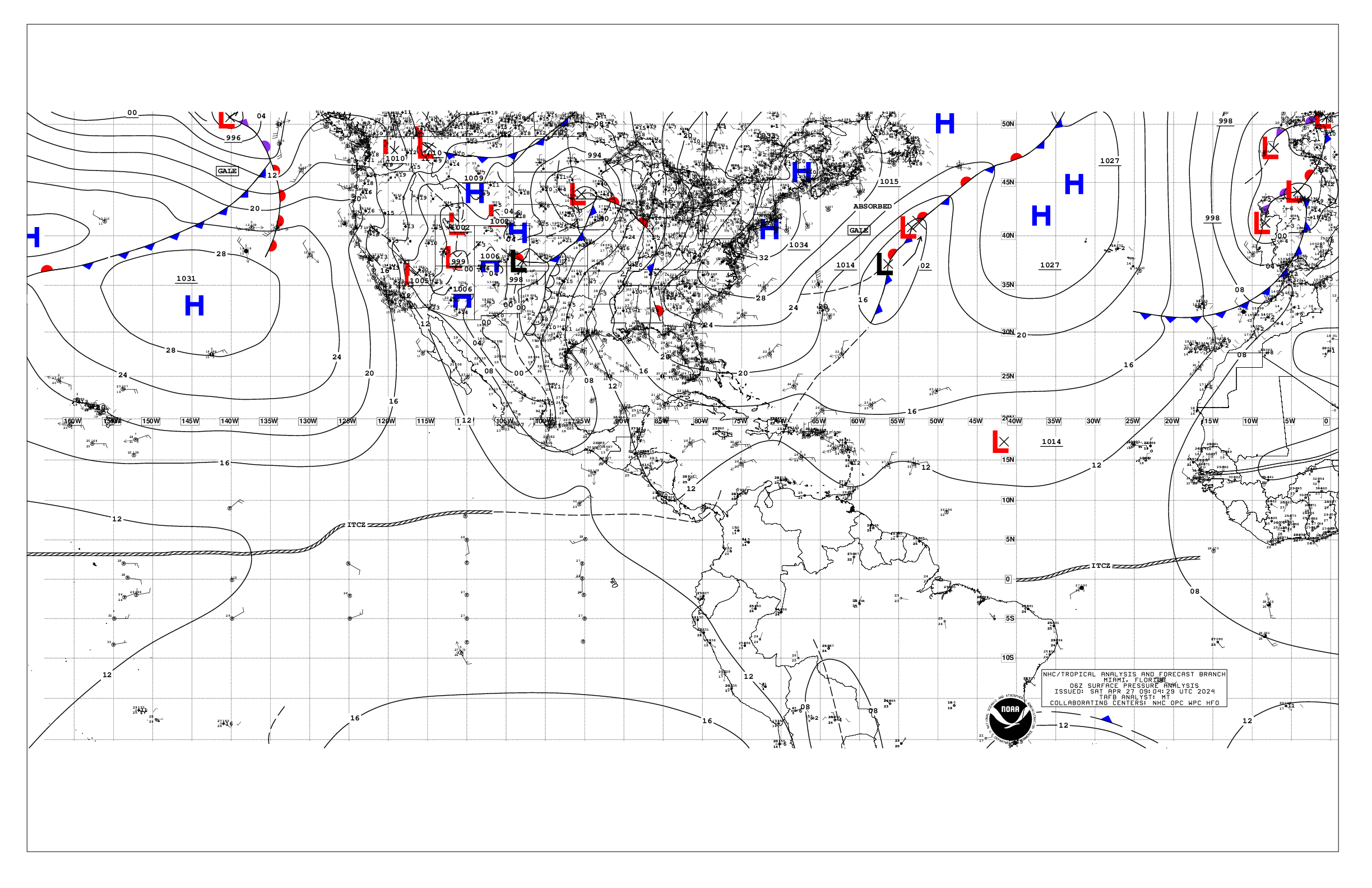
Based on 0600 UTC surface analysis and satellite imagery through
1030 UTC.

...SPECIAL FEATURES...

Gulf of America Gale Warning: A cold front extends from Apalachicola, Florida to
Veracruz, Mexico. A recent scatterometer satellite pass confirmed
gale force NW to N winds off the coast of the Mexican state of
Tamaulipas, and reaching southward to almost Tampico. Recent
altimeter data over the west-central Gulf along with buoy
observations over the northwest Gulf confirm rough to very rough
seas follow the front. Frequent gusts to gale force are ongoing
elsewhere north of the front this morning. Very dangerous marine
conditions are likely along the coast of Veracruz later today, as
strong gales out of the NW will funnel along the coast with seas
building as high as 25 ft. The gale conditions and very rough seas
will subside through late Sun night off Veracruz, but strong
winds and rough seas may not subside until mid week.

Atlantic Gale Warning: The front is starting to move off the coast
of northeast Florida this morning. The front will reach from 31N72W
to the Straits of Florida by early Sun morning, and from near
31N70W to western Cuba by early Mon morning, then stall and
dissipate into mid week. Frequent gusts to gale force will follow
the front Sun over the waters north of 29N and west of 75W.

Please read the latest High Seas Forecast issued by the National
Hurricane Center under AWIPS/WMO headers FZNT02 KNHC/HSFAT2 or at
website https://www.nhc.noaa.gov/text/MIAHSFAT2.shtml for further
details.

...MONSOON TROUGH/ITCZ...

The monsoon trough extends from 14N16n to 08N25W to 09N35W. Scattered
moderate convection from 06N to 10N between 15W and 35W. Scattered
moderate to isolated strong convection is active from 10N to 13N
between 40W and 45W.

...GULF OF AMERICA...

See details above about the Gulf of America Gale Warning.

A few showers and thunderstorms are active along the cold front,
reaching from Apalachicola, Florida to Veracruz, Mexico.
Additional showers and thunderstorms are active over the southeast
Gulf, ahead of an upper trough extending over the central Gulf.
Light to gentle NE winds and 1-3 ft seas are noted over the
southeast Gulf, south of the front.

For the forecast, the front will reach from Naples, Florida to
Coatzacoalcos, Mexico by this evening, followed by strong gales
and very rough seas over the southwest Gulf. The front will slow
down as it reaches from the Florida Straits to Merida, Mexico by
early Sun, then drift to the southeast of the Gulf through Tue as
it weakens. Gales will persist over the far southwest Gulf through
late Sun night, with strong NE winds and rough seas elsewhere
north of the front. Looking ahead, strong high pressure will build
over the lower Mississippi Valley behind the front, promoting
fresh NE to E winds mainly over the eastern half of the Gulf into
mid week.

...CARIBBEAN SEA...

Abundant low level moisture is converging across the NW Caribbean
and interacting with the upper trough across the central Gulf to
produce scattered to numerous moderate to strong convection across
the northwest Caribbean north of 18N and west of 80W, and between
Jamaica, eastern Cuba, and Haiti. At the surface, the seasonal
pressure gradient across the region is leading to moderate to
fresh trades across the south-central basin with steady 20 kt
winds off entrance to the Gulf of Venezuela and off Cabo Beata,
Dominican Republic. Moderate seas prevail across much of the
Caribbean, with rough seas 7 to 8 ft offshore Colombia.

For the forecast, as a cold front moves across the Western Atlantic
and the Gulf of America, the pressure gradient is relaxing across
the basin. This pattern will support moderate to fresh winds
offshore Colombia and in the Gulf of Venezuela with moderate to
locally rough seas near the coast of Colombia today. Moderate or
weaker winds and slight to moderate seas are forecast elsewhere.
An area of showers and thunderstorms associated with a surface
trough will continue to affect the NW Caribbean this morning.
Moisture associated with this feature will merge with the cold
front moving across the Gulf this weekend. The front will likely
reach western Cuba and the Yucatan Channel by Tue then dissipate.

...ATLANTIC OCEAN...

A cold front is starting to move off the northeast Florida coast.
Farther east a pair of weak stationary fronts are evident north of
22N between 45W and 75W. Scattered to numerous showers and
thunderstorms are active along one of the front near 26N47W.
Farther east, a trough is along 37W from 20N to 30N. A few shower
and fresh SE winds with 6-7 ft are active within 90 nm east of the
trough. Gentle to moderate E to SE breezes and 4-6 ft dominated
the remainder of the area.

For the forecast west of 55W, the pair of weak frontal boundaries
east of 75W will merge then dissipate through today, ahead of a
strong cold front that will move off the coast of northeast
Florida this morning. The front will reach from 31N72W to the
Straits of Florida by early Sun morning, and from near 31N70W to
western Cuba by early Mon morning, then stall and dissipate into
mid week. Strong to near- gale force winds and rough to very rough
seas will follow the front affecting mainly the waters W of 65W
through Tue.

$$

Christensen


 NHC on Facebook
 NHC on X
 NHC on YouTube
 NHC Blog: