000
AXNT20 KNHC 190454
TWDAT

Tropical Weather Discussion
NWS National Hurricane Center Miami FL
0615 UTC Mon Oct 19 2026

Tropical Weather Discussion for North America, Central America
Gulf of America, Caribbean Sea, northern sections of South
America, and Atlantic Ocean to the African coast from the
Equator to 31N. The following information is based on satellite
imagery, weather observations, radar and meteorological analysis.

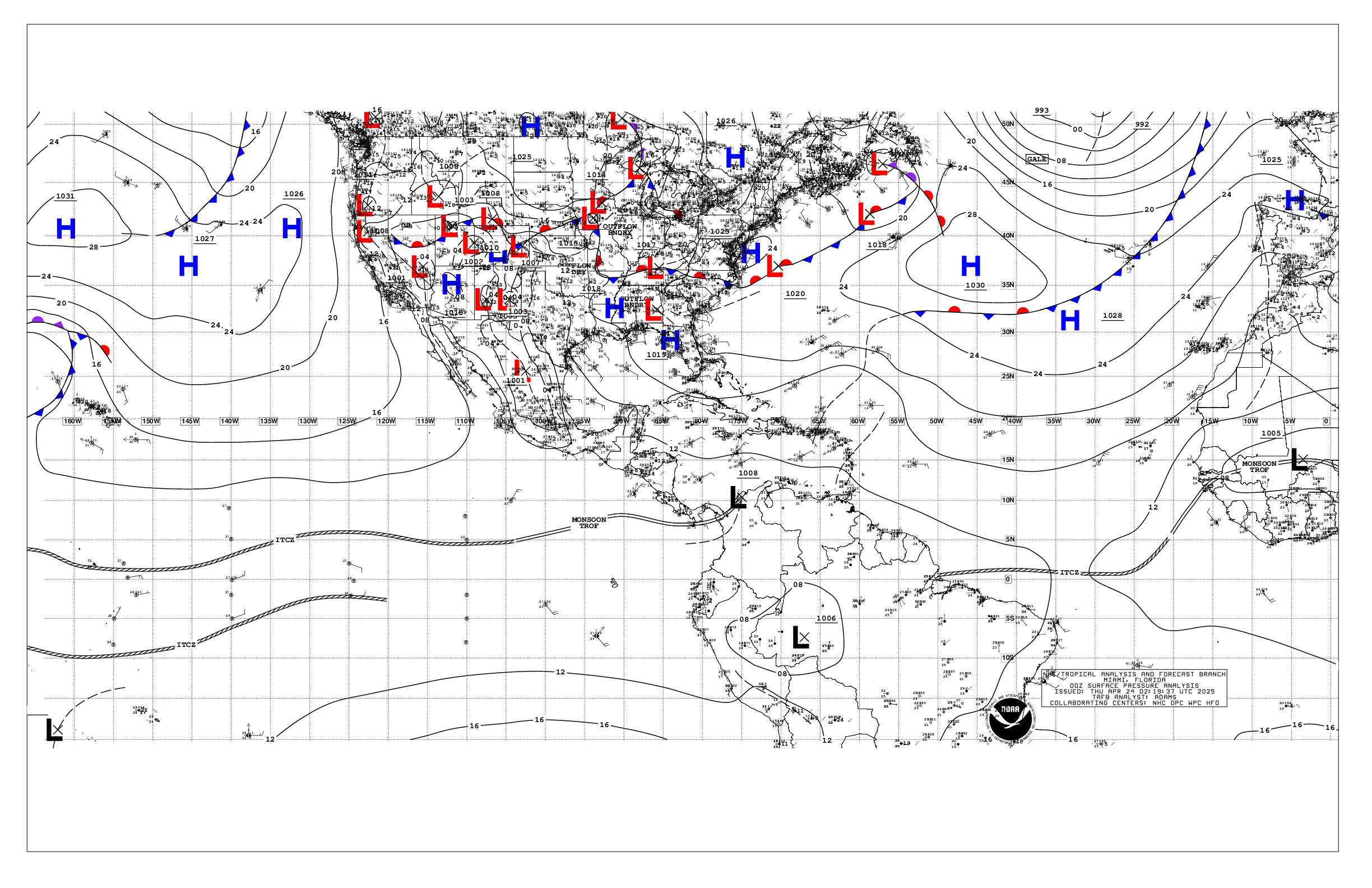
Based on 0000 UTC surface analysis and satellite imagery through
0430 UTC.

...SPECIAL FEATURES...

Gulf of America Gale Warning: A cold front has stalled tonight
across the southern Gulf, from the Straits of Florida to near
22N90W to the central Bay of Campeche and into the coast of
Mexico near 93W. satellite imagery suggests that the portion of
the front W of 90W has been drifting westward in recent hours.
1026 mb high pressure has moved into far NE Mexico, while 1035 mb
high pressure is across the NE U.S. extending a ridge southward
across the basin. The pressure gradient south of these highs is
forcing gale-force NW to N winds and very rough seas of 14-20 ft
across the SW waters of the Gulf, S of 21N between the front and
the Mexican coastline, while fresh to strong E-NE to NE winds and
seas of 8 to 12 ft prevail across most of the remainder of the
basin N of the front. The front will remain generally stationary
and weaken into Tue. Gale winds and very rough seas to 15 ft will
prevail in the SW basin through sunrise, then slowly diminish
through Tue night.

Atlantic Gale Warning: The aforementioned cold front is eastward
across the Atlantic waters N of 27N, and extends through 31N71.5W
to 27N73W then becomes nearly stationary through the NW Bahamas
and into the Straits of Florida. W of the cold front, N-NE to NE
winds of 20 to 30 kt prevail, with winds near gale-force and
frequent gusts to 40 kt N of 29N and W of 73W, where a Gale
Warning is in effect. Very rough seas of 12 to 16 ft prevail
across these waters. The front is associated with a deep low
pressure system across the western Atlantic currently near 32N71W.
The low is expected to lift northward overnight, which will slow
the forward progress of the front. Winds west of the front are
expected to gradually diminish later tonight, with gales ending by
morning.

Please read the latest High Seas Forecast issued by the National
Hurricane Center under AWIPS/WMO headers FZNT02 KNHC/HSFAT2 or at
website https://www.nhc.noaa.gov/text/MIAHSFAT2.shtml for further
details.

...MONSOON TROUGH/ITCZ...

The monsoon trough extends across western Africa to the coast of
Guiea-Bissau near 12N16W and extends about 60 nm to the southwest.
The ITCZ extends from 07N21W to 06N36W to 09.5N45W to the coast of
Guyana near 06.5N58W. Scattered to locally numerous moderate
isolated strong convection is occurring from 09N to 16.5N between
35W and 52W.

...GULF OF AMERICA...

See the Special Features section above for information on the Gale
Warning in effect for portions of the southwest basin. Outside
of the gales, recent satellite scatterometer data shows strong
E-NE winds 20-28 kt E of 92W, and fresh to strong NE to N winds W
of 92W and N of 21N. Seas of 8 to 12 ft prevail across most of
the basin N of the front, highest SW portions. Scattered showers
and thunderstorms are within 60 nm either side of the front.

For the forecast, the front will meander about over the Straits
of Florida and to the NW Yucatan Peninsula and Bay of Campeche
tonight through Mon, then drift to the southeast of the Gulf
through Tue as it weakens. Gale-force winds will persist over the
SW Gulf offshore Veracruz through early Mon morning, while winds
and seas diminish modestly across the remainder of the basin.
High pressure behind the front will continue to support fresh NE
to E winds mainly over the eastern half of the Gulf through Tue.

...CARIBBEAN SEA...

A weakening upper-level trough across the NW Caribbean continues
to support scattered to locally numerous moderate isolated strong
convection across the Gulf of Honduras and the waters within 150
nm of the NE coasts of Honduras and Nicaragua, while moderate
convection is further south across the SW basin in association
with the eastern extension of the East Pacific monsoon trough.
Stable atmospheric conditions and fair skies prevail across most
of the basin elsewhere E of 72W. A weak pressure gradient across
the region is yielding only moderate to fresh trades and seas of
4-6 ft seas across the central Caribbean S of 16N between 64W and
78W. Gentle to moderate or weaker winds and seas of 5 ft or less
prevail elsewhere.

For the forecast, a weak pressure gradient prevails across the
region due to a frontal boundary across the Bahamas and the
southern Gulf of America, and will maintain moderate to fresh
trades in the south-central Caribbean through Wed night and
moderate or weaker winds elsewhere. The cold front will likely
reach western Cuba and the Yucatan Channel Mon night into Tue
where it will remain through Wed before dissipating. Moderate to
fresh NE winds and moderate to rough seas will impact the waters
of Yucatan Channel and the NW Caribbean through early Wed
morning. Moderate to fresh SE winds will develop in the eastern
Caribbean on Thu, and prevail through Fri night as surface ridging
builds N of the area.

...ATLANTIC OCEAN...

See the Special Features section above for information on gales
ongoing southwest of Bermuda behind the cold front moving through
western Atlantic waters. Recent satellite scatterometer data shows
NE to N winds of 30 to 50 kt across a broad area of the western
Atlantic to the W of a 1010 mb surface low near 31N71W and an
associated frontal zone. Large seas of 12 to 20 ft in N to NE
swell prevail across the local waters N of 28N and W of 71W.
Recent satellite altimeter data showed seas 13-14 ft in the
Gulfstream offshore of Miami and Ft Lauderdale. Seas are 8 to 12
ft elsewhere NW of the front outside of the Bahamas. Scattered to
locally numerous moderate isolated strong convection is occurring
along and within 180 nm S of the front between 71W and 80W.

To the east of this cold front, a deep layered upper low continues
across the central Atlantic near 27N51W, and is promoting unstable
atmospheric conditions across that area. A pair of surface troughs
near this feature, along 60W and 53W are accompanied by scattered
moderate convection from 22N to 29N between 48W and 60W. Another
more significant surface trough from 31N49W to 23N42W is
interacting favorably with the upper low to produce scattered to
numerous moderate to strong convection along and within 240 nm E
of this surface trough. Fresh to locally strong E to E-SE winds
and seas of 7 to 11 ft in mixed N swell and E wind waves are
found east of the surface trough to 40W. Moderate winds and seas
of 4 to 6 ft prevail near the pair of troughs to the W. To the
south of these features, a weak pressure gradient is yielding
gentle to moderate easterly winds and seas of 4 to 6 ft between
35W and the Lesser Antilles. A series of 3 low level easterly
perturbations in the trade wind flow are producing scattered to
locally numerous moderate isolated strong convection from 09N to
16.5N between 35W and 52W. To the E of 35W moderate to fresh NE to
E winds generally prevail between the Canary Islands, Africa and
35W, with seas of 4 to 7 ft in NW to N swell.

For the forecast west of 55W, the cold front will extend from
31N71W to the central Bahamas and the Straits of Florida by early
Mon morning, and from near 31N70W to west-central Cuba by Mon
night, where it will weaken before dissipating into midweek. The
low pressure system associated with the front near 32N71W will
lift northward tonight, allowing winds to gradually diminish
behind the front tonight through Mon. Large N to NE swell
generated by this low pressure will affect the Atlantic waters W
of 68W through Tue night, then subside modestly, then increase
again Wed through Fri across the waters W of 65W.

$$
Stripling


 NHC on Facebook
 NHC on X
 NHC on YouTube
 NHC Blog: