142
AXNT20 KNHC 062327
TWDAT

Tropical Weather Discussion
NWS National Hurricane Center Miami FL
0015 UTC Sat Nov 7 2026

Tropical Weather Discussion for North America, Central America
Gulf of America, Caribbean Sea, northern sections of South
America, and Atlantic Ocean to the African coast from the
Equator to 31N. The following information is based on satellite
imagery, weather observations, radar and meteorological analysis.

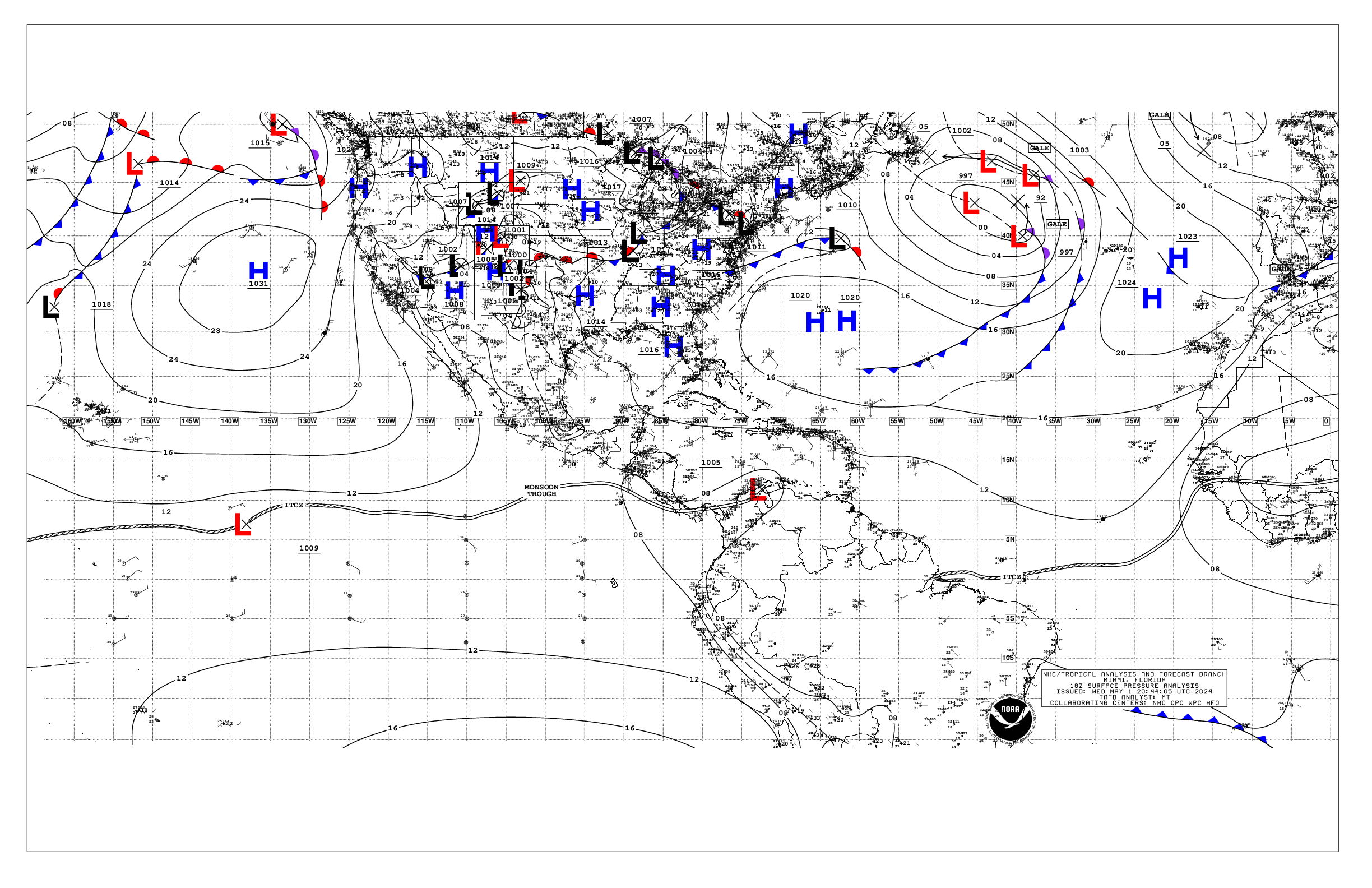
Based on 1800 UTC surface analysis and satellite imagery through
2230 UTC.

...SPECIAL FEATURES...

Western Atlantic Gale Warning: A 1003 mb low pressure area, Invest
AL94, is located near 25N64.5W, with a cold front extending from
the low east-northeastward across the basin to 31N34W. High
pressure is centered north of these features over the NW Atlantic.
The resultant pressure gradient is producing fresh to near gale-
force NE to E winds across the north semicircle of the low east of
69W, and extending eastward, north of the cold front, to 40W, per
recent satellite scatterometer data. Seas are 8 to 15 ft within
these winds. Scattered moderate isolated strong convection is also
noted in the same region while numerous moderate to strong
convection is north of 20N between 47W and 62W. The chances of
this low acquiring subtropical characteristics are decreasing due
to strong upper-level winds that are expected to persist over the
system into the weekend. The low is forecast to move generally
eastward over the western and central subtropical Atlantic during
the next couple of days and become absorbed by a new non-tropical
low pressure system to its east later this weekend. Regardless,
gale-force winds are likely to develop across the northern
semicircle of the low this evening, and then along the cold front
Sat through Sun morning, as the low tracks slowly eastward. For
more information, including Gale Warnings, see High Seas Forecasts
issued by the National Weather Service. Please read the latest
High Seas Forecast issued by the National Hurricane Center at
website:
https://nhc.noaa.gov/text/HSFAT2.html and the latest Tropical
weather outlook at website:
https://nhc.noaa.gov/text/TWOEP.html for more details.

Eastern Atlantic Gale Warning:
The pressure gradient between the aforementioned cold front and
an eastern Atlantic high pressure ridge S of 20N between 30W and
60W is supporting near-gale to gale force SW to W winds from 25N
to 27.5N between 33W and 39W. Seas within these winds are 8 to 11
ft. A non-tropical low is forecast to develop across this area
tonight and move eastward, accompanied by near-gale to gale force
SW winds. By Sat 12Z near- gale to gale force winds will prevail
north of 26.5N between 21W and 25W. Peak seas to around 14 ft will
likely occur late tonight and Sat morning. Conditions will
improve Sat evening and the system move north of the area. Please
read the latest High Seas Forecast issued by the National
Hurricane Center at website:
https://nhc.noaa.gov/text/HSFAT2.html for more information

Heavy Precipitation across Central America: Middle-level
troughing over the SW Caribbean and upper level divergence over
Central America and into the tropical eastern Pacific will
interact with enhanced low-level moisture and onshore flow south
of the monsoon trough over the next few days. This will favor
heavy precipitation developing across Central America through at
least Saturday. The heaviest precipitation is expected across
Nicaragua and Costa Rica, which may lead to life-threatening flash
flooding and landslides. Please refer to your local weather
agency and the International Desk at the Weather Prediction Center
for more details.

...MONSOON TROUGH/ITCZ...

The monsoon trough enters the Atlantic near 11N15.5W and extends
to 08.5N18W, where it transitions to ITCZ, continuing on to 08N30W
to 05.5N50W. Scattered to numerous moderate isolated strong convection
is noted from 01N to 11N between 24W and 41W.

...GULF OF AMERICA...

A front has become stationary from the Florida Panhandle near
31N84W and continues southwestward to 25.5N91W to 26N96W.
Scattered moderate convection is found from 22N to 26.5N and west
of 94W. Gentle N to NE winds prevail north of the front. Elsewhere,
a weak pressure gradient supports mainly light to gentle winds,
with slight seas basin-wide.

For the forecast, the front will slowly shift across the basin
into early next week as high pressure builds north of the front.
Mainly moderate to fresh winds will prevail behind the front.

...CARIBBEAN SEA...

The broad low pressure across the western Atlantic the past few
days has completely disrupted the trade wind flow across the
Caribbean basin. Over the NE part of the basin, a deep- layered
trough is supporting scattered to numerous moderate convection N
of 14.5N between 70W and the Anegada Passage. Light to gentle S to
SW winds prevail across the area. Broad cyclonic flow generally
dominates the rest of the basin. A surface trough is supporting
scattered convection from 15N to 19N and west of 80W, where 1009
mb low pressure is anaylzed near 15N82W. Light to gentle cyclonic
winds prevail W of 70W, except stronger in convection. Seas are 1
to 3 ft E portions and 2 to 5 ft W portions.

For the forecast, a weak pressure gradient across the basin will
result in moderate or weaker winds, with slight to moderate seas,
through early next week. Easterly winds will begin to return to
the basin Monday and strengthen over the central Caribbean
Tuesday.

...ATLANTIC OCEAN...

Please see the Special Features section for information on the
Gale Warnings and the potential for subtropical development of
Invest AL94.

A stationary front extends from 31N34W to near Invest AL94.
Scattered to numerous moderate convection is depicted north of
22N between 28W and 63W. Aside from the Gale Warnings moderate to
fresh winds along with seas 5 to 8 ft previal N of the front to
75W. To the south of Invest AL94, fresh SW to W winds prevail
between 50W and 70W and become N to NE across the central and SE
Bahamas. Farther east, a ridge extends south of the front through
20N35W to the central Lesser Antilles. gentle to moderate
anticyclonic winds generally prevail there, with seas of 4 to 6 ft
in N swell. Elsewhere, gentle or lighter winds and seas 4 to 5 ft
prevail.

For the forecast west of 55W, the 1003 mb low pres near 25N64.5W,
Invest AL94, will drift slowly move east-northeastward. A second
low may develop east of this low by Sat. The lows will merge over
the eastern waters late in the weekend, then shift east of the
area by early next week. An area of strong to gale- force winds,
and rough to very rough seas, peaking near 15 ft, will persist
north of the lows, impacting the waters mainly north of about 27N
and east of 65W through Sat night. Elsewhere, a weakening cold
front will move across the waters between Florida and 75W tonight,
then dissipate by Sun.

$$
Stripling


 NHC on Facebook
 NHC on X
 NHC on YouTube
 NHC Blog: