388
AXNT20 KNHC 241026
TWDAT

Tropical Weather Discussion
NWS National Hurricane Center Miami FL
1215 UTC Thu Sep 24 2026

Tropical Weather Discussion for North America, Central America
Gulf of America, Caribbean Sea, northern sections of South
America, and Atlantic Ocean to the African coast from the
Equator to 31N. The following information is based on satellite
imagery, weather observations, radar and meteorological analysis.

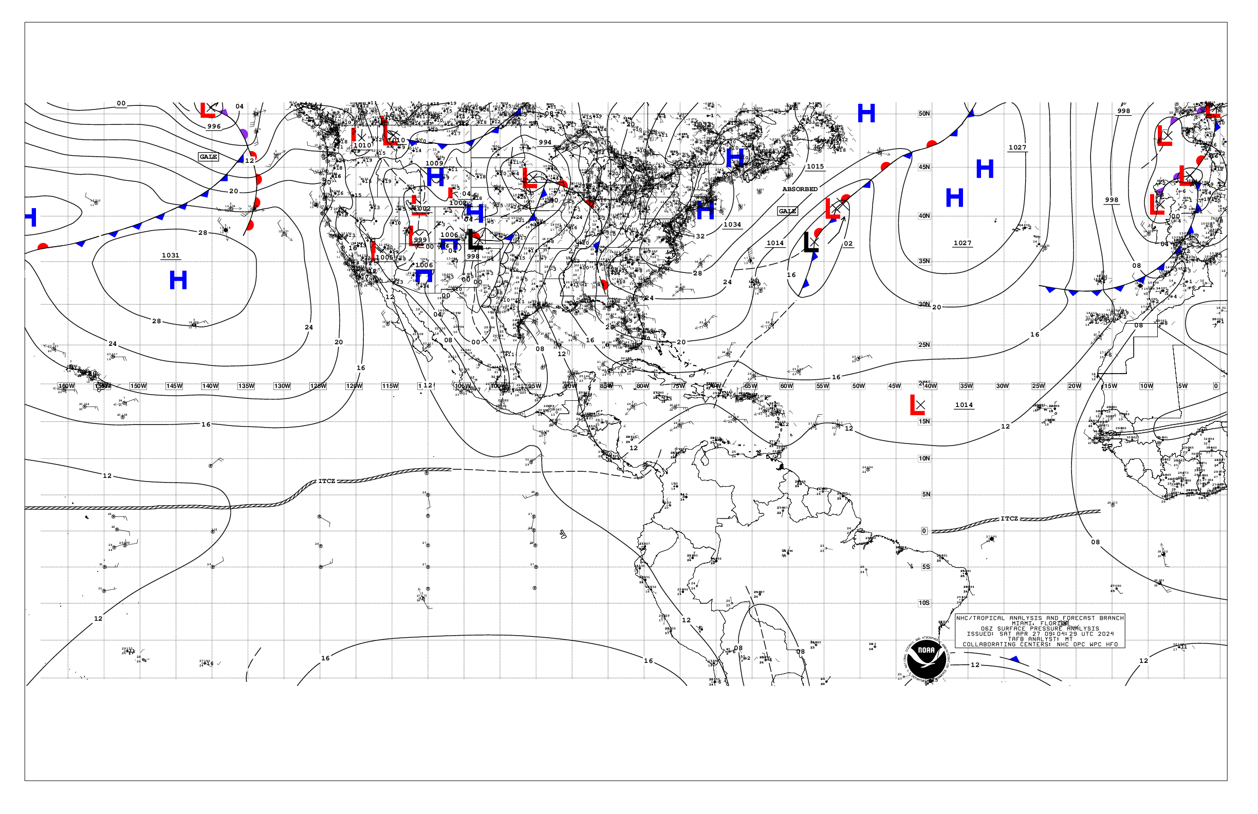
Based on 0600 UTC surface analysis and satellite imagery through
1015 UTC.

...SPECIAL FEATURES...

Tropical Storm Fay: Tropical Storm Fay is centered near 29.8N
40.5W at 24/0900 UTC or 830 nm WSW of the Azores, moving W at 6
kt. Estimated minimum central pressure is 1010 mb. Maximum
sustained wind speed is 35 kt with gusts to 45 kt. Peak seas to
11 ft are occurring within 75 nm across the NW semicircle.
Scattered moderate isolated strong convection is noted within 120
nm NE and 45 nm SW quadrants. Fay is forecast to maintain minimal
tropical storm strength and move westward through Fri morning then
begin to weaken through this weekend.

Please read the latest HIGH SEAS FORECAST issued by the National
Hurricane Center at website -
https://www.nhc.noaa.gov/text/MIAHSFAT2.shtml and the latest Fay
NHC Forecast/Advisory and Public Advisory at www.hurricanes.gov
for more details.

Far Eastern Tropical Atlantic (AL90): An area of low pressure
located a few hundred miles south-southeast of the Cabo Verde
Islands is accompanied by a large area of disorganized showers and
thunderstorms mainly E of 26W. A tropical wave accompanies this
low. This system could become a short-lived tropical depression
later today or on Friday while it moves northwestward to
northward. However, strong upper-level winds should end the
opportunity for development by the weekend. Interests in the Cabo
Verde Islands should monitor the progress of this system as gusty
winds, areas of heavy rain, and flash flooding are possible there
by Friday. This system has a medium chance of formation in the
next 48 hours.

Heavy Rainfall in Central America: A mid to upper-level trough
currently extends from the eastern Gulf of America across the
Yucatan Peninsula and NW Caribbean, while relatively warm sea
surface temperatures and abundant low level moisture are present.
An elongated low level trough will prevail across this area during
the next several days, and aid in funneling enhanced tropical
moisture across Central America and the western Caribbean,
supporting periods of heavy rainfall through Sat the 26th. There
is still some uncertainty regarding the exact location of heaviest
rainfall, but for now heavy rainfall looks likely across extreme
southeastern Mexico near Chiapas, southern and central Guatemala,
western Honduras, El Salvador, southern and eastern Belize, as
well as across portions of Costa Rica and Panama. Currently, heavy
rainfall is ongoing from northern Honduras, E of 87W, north-
northeastward across the Cayman Islands and into the southern
coastal waters of Cuba, and across Andros Island and the
remainder of the NW Bahamas W of 75W. Heavy rainfall across these
regions will create the possibility of life-threatening flash
flooding and landslides. Please refer to local weather services as
well as the International Desk at the Weather Prediction Center
for more information.

...TROPICAL WAVES...

See Special Features section above for information on a tropical
wave in the far eastern Atlantic along 20N that has potential for
tropical formation.

A central Atlantic tropical wave is analyzed along 47W, S of 13W,
moving west at around 10 kt. Scattered moderate convection is
noted within 60 nm of the wave axis along the monsoon trough from
09N to 11N.

An eastern Caribbean tropical wave is along 65W, south of 14N
into southern Venezuela, moving westward at 10 to 15 kt. Scattered
moderate convection is noted S of 12N between 60W and 64W, while
numerous moderate to strong convection is near the wave axis well
inland from 01N to 08N.

...MONSOON TROUGH/ITCZ...

The monsoon trough enters the E Atlantic near 20N16W and meanders
southward to 1008 low pressure near 12N21W then continues
westward to 10.5N47W. The ITCZ extends from 08N49W continues to
the coast of Guyana near 08N59W. Scattered moderate to strong
convection is noted within 90 nm on either side of the boundary
and E of 32W, and from 09N to 13N and E of 49W.

...GULF OF AMERICA...

Deep-layered upper troughing continues across the eastern Gulf
from the coastal Carolinas across N Florida to the eastern Bay of
Campeche. Multi-layered clouds and scattered moderate convection
is noted from the Yucatan Peninsula northeastward across the
Straits of Florida and south Florida and into the Bahamas. To the
west, widely scattered showers are occurring along a surface
trough across southwest portions from Cabo Rojo, Mexico the the
central Bay of Campeche. At the surface, weak high pressure
prevails across the northern Gulf, ahead of an approaching cold
front extending just inland across the northern Gulf states and
across the coastal waters of the Florida Big Bend. Gentle to
moderate E-NE to E winds dominate the Gulf N of 25N, with 2-4 ft
seas. Light to gentle winds prevail south of 25N, except for
moderate N to NE winds along the NW coast of the Yucatan.

For the forecast, the weak pressure gradient will generate gentle
to moderate winds across the remainder of the basin through
today. The upper-level trough will support scattered showers and
thunderstorms over the SE Gulf and the Straits of Florida for at
least the next couple of days. The front is forecast to progress
across the E Gulf tonight and Fri, then stall over the SE Gulf
this weekend.

...CARIBBEAN SEA...

Please see Special Features section above for information on
upper-level low pressure across the far western Caribbean,
and expected to produce areas of heavy rainfall over portions of
Central America into the weekend.

To the east, deep-layered low pressure extends from the weak
pressure pattern prevails from the central Atlantic southwestward
to northern Venezuela. A low level trough is moving across Puerto
Rico and interacting with the upper trough to produce scattered
showers dotting the waters surrounding Puerto Rico and the Virgin
Island and portions of the eastern Caribbean. A tropical wave is
across the southeast Caribbean and mostly impacting interior
portions of Venezuela with numerous strong showers and
thunderstorms.

At the surface, high pressure across the central Atlantic extends
a weak ridge into the Bahamas, producing a weak pressure gradient
across the Caribbean basin. Moderate trades prevail across most
of the basin S of 16N and E of 79W, while fresh to strong winds
are S of 13.5N to the coasts of NW Venezuela and extreme NE
Colombia. Seas in these winds are 4 to 7 ft, and 3 to 5 ft in the
moderate winds. Outside of convection, light to gentle winds and
slight seas prevail elsewhere across the SW and NW Caribbean.

For the forecast, the weak pressure gradient will generate
moderate to fresh trades over the S central Caribbean, and gentle
to moderate winds elsewhere. The upper-level trough will support
scattered to numerous showers and thunderstorms over the W
Caribbean for the next couple of days.

...ATLANTIC OCEAN...

See Special Features section above for information on Tropical
Storm Fay over the central Atlantic well east-southeast of
Bermuda.

A deep-layered upper trough extending from the middle Atlantic
states of the U.S. S-SW across the eastern Gulf of America
continues to support scattered to numerous showers and
thunderstorms from the NW Caribbean across the NW and central
Bahamas and adjacent Atlantic waters. Abundant low-level tropical
moisture is across much of the Atlantic W of 68W, trapped to the
south of an approaching front offshore of the SE U.S. and is
interacting with the upper trough. A surface trough is analyzed
within this convection across the NW Bahamas through the Straits
of Florida. A weak frontal boundary has become stationary across
the NW waters from 31N75W to northern Florida. Moderate to fresh
N-NE winds are filling in behind this front W of 75W, building
seas to 5-7 ft. Another upper-level low is drifting westward near
24N54W, and extends a trough SW across the eastern Caribbean.
This feature is interacting with a surface trough resulting in an
area of scattered moderate convection from 21N to 26.5N between
49W and 57W. Outside of this convection, a weak pressure gradient
continues across much of the Atlantic, as high pressure remains
centered across the far NE Atlantic offshore of Europe. This
pattern is sustaining gentle to moderate trades S of 20N and
variable light to gentle winds elsewhere W of 35W, except for
moderate SE to S winds over the area N of 30N between 60W and 70W.
Seas are 2 to 5 ft W of 60W, and 4 to 6 ft elsewhere across the
basin. However, swell generated from Tropical Storm Fay is
producing seas of 6 to 11 ft N of 27N between 36W and 43W.

For the forecast west of 55W, a weak pressure gradient will support
gentle to moderate trades across forecast waters through tonight.
An upper-level trough will produce scattered showers and
thunderstorms west of 65W for the next couple of days. Deepening
low pressure across the western Atlantic will push a frontal
boundary off the SE United States coast late tonight. The front
will shift eastward, reaching from near Bermuda to the straits of
Florida Sat night before starting to weaken. Fresh to strong winds
and large N to NE swell will follow the front on Thu and Fri,
before beginning to slowly subside Sat through Sun.

$$
ERA


 NHC on Facebook
 NHC on X
 NHC on YouTube
 NHC Blog: