000
AXNT20 KNHC 272351
TWDAT

Tropical Weather Discussion
NWS National Hurricane Center Miami FL
0015 UTC Thu May 28 2026

Tropical Weather Discussion for North America, Central America
Gulf of America, Caribbean Sea, northern sections of South
America, and Atlantic Ocean to the African coast from the
Equator to 31N. The following information is based on satellite
imagery, weather observations, radar and meteorological analysis.

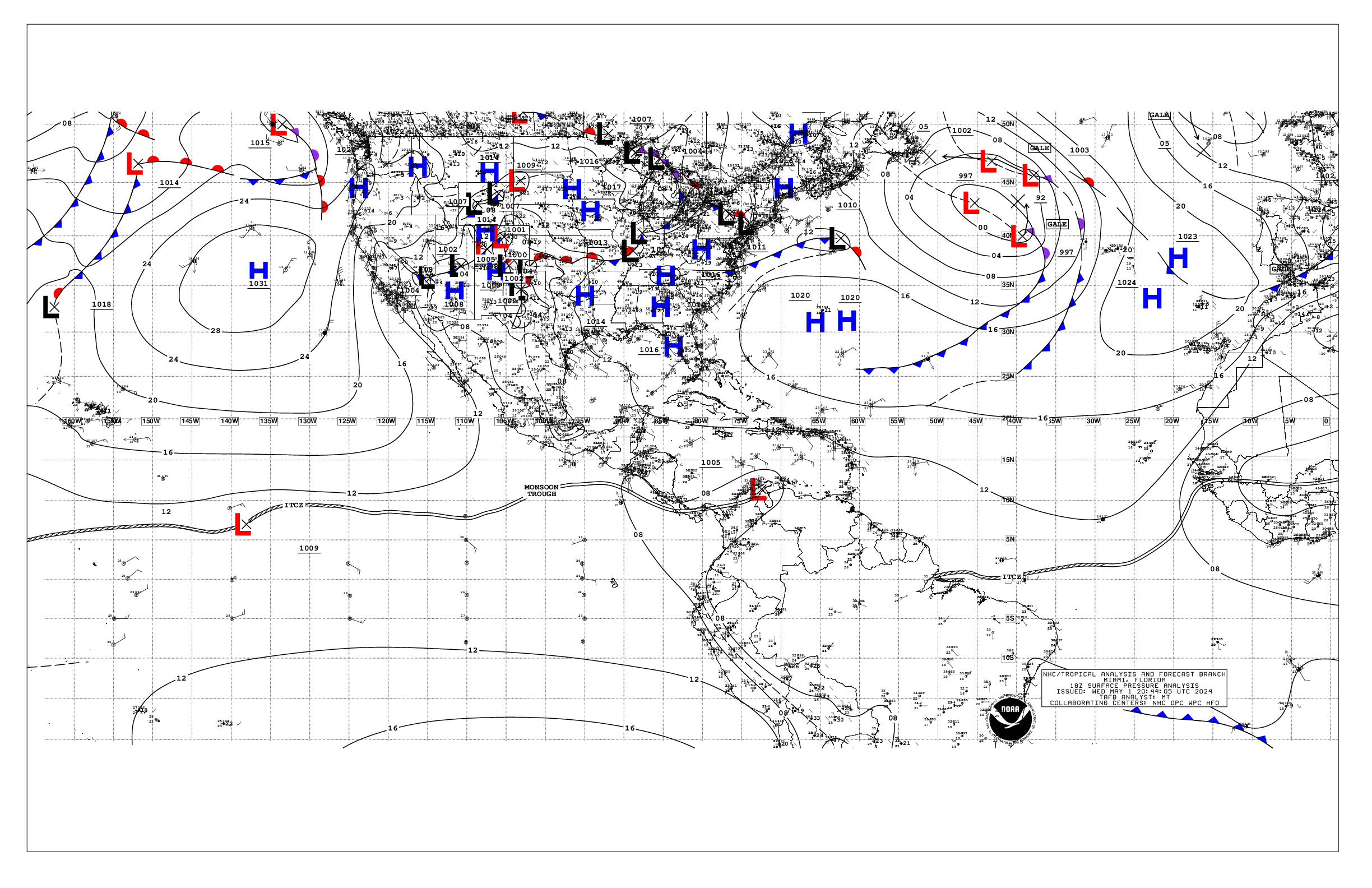
Based on 1800 UTC surface analysis and satellite imagery through
2345 UTC.

...TROPICAL WAVES...

An eastern Atlantic tropical wave has its axis along 38W from
01N to 15N, moving westward at about 15 to 20 kt. This wave
remains embedded in a dry Saharan airmass that is suppressing
deep convection from forming near it. Only isolated showers are
within 120 nm west of the wave from 05N to 08N and within 120 nm
east of the wave from 07N to 09N.

A central Atlantic tropical wave has its axis along 50W from 01N
to 13N, moving westward at 10 to 15 kt. Isolated showers and
thunderstorms are seen south of 06N between 49W and 51W.

A central Caribbean tropical wave has its axis along 76W south
of 15N. It is moving westward at 10 to 15 kt. Isolated showers
and thunderstorms are near the wave axis south of 14N.

...MONSOON TROUGH/ITCZ...

The monsoon trough axis enters the Atlantic through the coast of
Guinea-Bissau near 12N16W and continues southwestward to 06N21W,
where it transitions to the ITCZ to 05N30W, then briefly pauses
at 04N38W. It resumes at 04N39W to 02N49W. Scattered moderate
convection within 120 nm north of the trough between 19W-21W.
Similar convection is southeast of the trough from 03N to 09N
between 10W-17W.

...GULF OF AMERICA...

The upper-level flow pattern attributed to a rather robust
upper-level trough that is over the west-central Gulf is drawing
abundant deep tropical moisture northward from the Caribbean and
into the eastern and central Gulf. This is resulting in
scattered to numerous showers and thunderstorms, some strong,
primarily over the NW and NE Gulf waters. A squall line moving
quickly east-southeastward across the NW Gulf waters is analyzed
from south- central Louisiana to 27N93W and to the coast of
Mexico at 25N98W. Scattered showers and thunderstorms are over
the western half of the Yucatan Peninsula and its interior
portions. Otherwise, the pressure gradient related to the western
extension of weak Atlantic ridging is maintaining moderate or
weaker winds. Seas are of moderate state with these winds.

For the forecast, the aforementioned squall line of active
thunderstorms will continue to move across the NW Gulf tonight.
Expect periods of heavy rainfall, frequent lightning, wind gusts
to gale-force and locally rough seas with this activity.
Otherwise, the Atlantic ridge extends westward across north
Florida and the northern Gulf coasts, and will sustain moderate
to locally fresh SE to S winds through Fri, then diminish to
gentle to moderate over the weekend. The exception will be
evening pulses of fresh to strong winds off the northern Yucatan
this evening and again Thu. The energetic upper-level trough
that is over the west-central Gulf should continue to combine
with abundant tropical moisture to produce scattered showers and
strong thunderstorms over the central and eastern Gulf through
Thu. Mariners are urged to keep up to date with the latest
forecasts.

...CARIBBEAN SEA...

The interaction between high pressure of 1023 mb centered over
the western Atlantic with relatively lower pressure to the south
over the Caribbean and in northern South America is bringing
fresh to near gale-force trades along with rough to locally very
rough seas over the central Caribbean. Seas are peaking up to 13
ft off northwest Colombia as revealed by an earlier altimeter
satellite data pass. Moderate to fresh trades and mostly moderate
seas are present elsewhere. The southeastern periphery of a
rather robust upper-level trough is supporting scattered to
numerous showers and thunderstorms over and near western Cuba,
and over some areas of the northwestern Caribbean. Similar
convection is just offshore eastern Honduras, Nicaragua and Costa
Rica. Scattered showers and thunderstorms are also over the
interior sections of central Cuba and Hispaniola as well as over
northern and southern Panama. Isolated showers are elsewhere west
of 79W.

For the forecast, a tight pressure gradient between 1023 mb high
pressure in the western Atlantic and a 1007 mb Colombian low
will continue to support fresh to strong trades and rough seas
across the central Caribbean through Thu morning before gradually
diminishing in areal coverage Thu evening through Fri. Winds are
expected to pulse to near-gale force off northwest Colombia
tonight through Thu morning. Trades in the Gulf of Honduras and
just north of Jamaica will reach fresh to strong speeds this
evening through early Thu morning. The high pressure will shift
eastward Thu night through the weekend, leaving a weakened
Atlantic ridge north of the Caribbean. This will yield moderate
to locally fresh winds and moderate seas across most of the basin
through the weekend, except in the south-central basin, where
fresh to strong winds and rough seas will remain.

...ATLANTIC OCEAN...

High pressure of 1023 mb is located near 29N68W, with a ridge
stretching westward across northern Florida and to the north-
central Gulf of America. To the east, a 1024 mb high center is
near 30N31W. A weak stationary front is analyzed from near
31N23W to 27N30W, where it transitions to a weak trough to 25N40W
and to 24N49W. Another weak trough extends from near 31N46W to
25N60W and northwestward to 27N68W. No significant convection is
occurring with these features. High pressure is present over
the rest of the basin north of about 15N anchored by the two
previously mentioned high centers. Moderate to fresh trades
along with moderate to locally rough seas are south of
20N and east of 35W, also south of about 25N and east of 35W,
and south of a line from northeast Florida to the northern
Leeward Islands. Elsewhere, light to gentle winds are noted. Seas
with these winds are of moderate state.

For the forecast west of 55W, the present pattern is expected to
produce fresh to strong winds with moderate to rough seas south
of 24N and west of 65W through tonight, including the Great
Bahama Bank, as the high begins to shift eastward. The ridge will
remain in place, but weaken as this occurs, allowing winds and
seas to begin to diminish. Looking ahead, two cold fronts will
sweep eastward across the north Atlantic are expected to produce
increasing winds and seas north of 28N and east of 70W from Thu
night through Fri evening, then again from Sat night through Sun
night.

$$
Aguirre


 NHC on Facebook
 NHC on X
 NHC on YouTube
 NHC Blog: