000
AXNT20 KNHC 301744
TWDAT

Tropical Weather Discussion
NWS National Hurricane Center Miami FL
1815 UTC Fri Oct 30 2026

Tropical Weather Discussion for North America, Central America
Gulf of America, Caribbean Sea, northern sections of South
America, and Atlantic Ocean to the African coast from the
Equator to 31N. The following information is based on satellite
imagery, weather observations, radar and meteorological analysis.

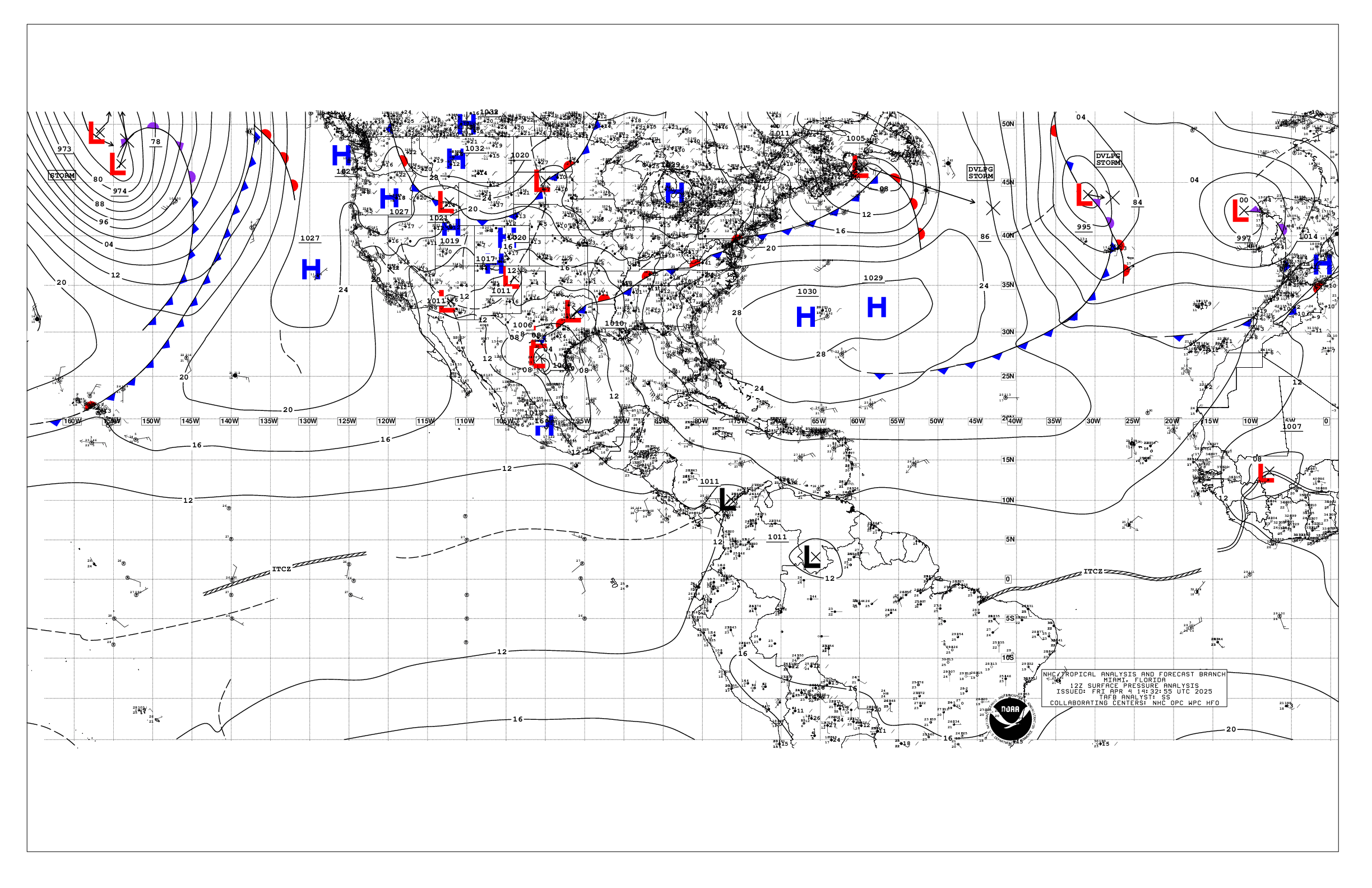
Based on 1200 UTC surface analysis and satellite imagery through
1700 UTC.

...MONSOON TROUGH/ITCZ...

The monsoon trough axis reaches the Atlantic through the coast of
Senegal near 14N17W and continues southwestward to 06N28W, where
it transitions to the ITCZ. the ITCZ then continues to near
05N54W. Scattered moderate convection is occurring from 03N to 10N
and E of 30W.

...GULF OF AMERICA...

A tight pressure gradient between high pressure over the eastern
United States, a surface trough over the Bahamas and a trough
over the south-central Gulf are supporting moderate to fresh
northeast to east winds across the northeast and north-central
Gulf. Moderate seas to 6-7 ft are with these winds. Moderate or
weaker winds are elsewhere as noted in recent scatterometer
passes.

For the forecast, a modest pressure gradient between high
pressure over the eastern U.S. and lower pressure over the Bahamas
and the NW Caribbean will continue to support moderate to fresh
NE to E winds and moderate seas across the northeast and north-
central Gulf into early next week. Looking ahead, expect fresh SE
to S winds to develop over much of the northwest Gulf by Tue
night, as a cold front moves through the Southern Plains.

...CARIBBEAN SEA...

The pressure gradient between higher pressure over the Gulf and
Atlantic and lower pressure over Colombia supports fresh to strong
trades and 5-7 ft seas in the south-central Caribbean and Gulf of
Venezuela. Moderate to fresh trades and 3-6 ft seas prevail across
the remainder of the central and eastern Caribbean, with gentle to
moderate or weaker winds and slight seas elsewhere. A surface
trough analyzed from Jamaica to the north coast of Panama supports
scattered moderate convection S of 17N between 74W and 81W.
Scattered moderate convection is also occurring in the SE
Caribbean S of 14N and E of 68W, driven by convergent surface
winds and an upper-level trough.

For the forecast, a lingering frontal trough extends from 1012 mb
low pres near 30N67W to 27N79W, allowing for a modest pressure
gradient to the south, and across the Caribbean basin. The low
pres will shift NE through the weekend, with strong high pressure
building into the western Atlantic, and forcing the frontal trough
southward through the NW Bahamas. Expect moderate to fresh trades
over the central and eastern Caribbean to continue through Mon
night, with small areas of strong winds near the coast of Colombia
and NW Venezuela. Winds and seas are expected to diminish basin-
wide late Mon through Tue as broad low pressure begins to develop
across the Atlantic to the NE of the Bahamas.

...ATLANTIC OCEAN...

A 1012 mb low is analyzed near 30N67W. A cold front extends from
this low to the waters north of the Turks and Caicos. A stationary
front also extends from another low north of the area to 31N57W to
23N36W to 31N25W. A surface trough also extends from the low to
just north of the Bahamas and then to near the Florida Keys.
Fresh to strong E to NE winds and seas of 6-10 ft prevail N of the
large stationary front and surface trough. Scattered showers and
thunderstorms are along and ahead of the cold front, generally N
of 22N and W of 61W. Scattered showers and thunderstorms are also
along and ahead of the stationary front N of 20N between 20W and
35W. Elsewhere across the Atlantic, moderate or weaker trades and
3-6 ft seas prevail.

For the forecast west of 55W, 1012 mb low pres near 30N67W
extends a cold front S-SW into the southeast Bahamas, while a
lingering frontal trough extends from the low pres to near 27N79W.
Fresh to strong NE to E winds with rough seas to around 12 ft
will persist north of the frontal trough into next week, as the
low pressure moves northeastward past Bermuda, and strong high
pressure gradually builds into the western Atlantic. This will
reinvigorate the frontal trough and force it southeastward, where
it will stall near 25N Sun, then lift northward Mon and Tue as
broad low pressure begins to develop NE of the Bahamas.

$$
Adams


 NHC on Facebook
 NHC on X
 NHC on YouTube
 NHC Blog: