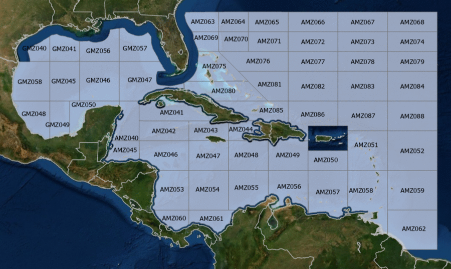
Hover to view popup zone forecast; click a zone to view related text forecast below.Show All Text Below
Southwest Tropical North Atlantic & Caribbean Sea (OFFNT3)
000
FZNT23 KNHC 101958
OFFNT3

Offshore Waters Forecast for the Caribbean Sea and Tropical
N Atlantic
NWS National Hurricane Center Miami, FL
358 PM EDT Fri May 10 2024

Offshore Waters Forecast for Caribbean Sea, and the Tropical N
Atlantic from 07N to 19N W of 55W.

Seas given as significant wave height, which is the average
height of the highest 1/3 of the waves. Individual waves may be
more than twice the significant wave height.
Synopsis for the Caribbean Sea & Tropical North Atlantic
AMZ001-110800-
Synopsis for Caribbean Sea, and Tropical N Atlantic from 07N to
19N W of 55W
358 PM EDT Fri May 10 2024

.SYNOPSIS...High pressure N of the basin will support fresh to
strong winds near the Gulf of Honduras, moderate to fresh winds
in the S-central and SE Caribbean, with gentle to moderate
winds elsewhere through the weekend. The pressure gradient will
tighten early next week, with fresh to strong trades in the
S-central and NW Caribbean, and moderate to fresh elsewhere. Seas
will build next week as a result of the increasing winds.
Meanwhile, haze due to agricultural fires in Central America
continues across most of the NW Caribbean.
AMZ040 Zone Forecast
AMZ040-110800-
Caribbean N of 18N W of 85W including Yucatan Basin-
358 PM EDT Fri May 10 2024

.TONIGHT...E to SE winds 15 to 20 kt. Seas 2 to 4 ft.
Haze. Vsby 1 NM or less.
.SAT...E to SE winds 10 to 15 kt. Seas 3 ft or less in Yucatan
Channel, and 3 to 5 ft elsewhere.
.SAT NIGHT...E to SE winds 10 to 15 kt. Seas 3 ft or less in
Yucatan Channel, and 2 to 4 ft elsewhere.
.SUN...E to SE winds 10 to 15 kt. Seas 3 ft or less in Yucatan
Channel, and 2 to 4 ft elsewhere.
.SUN NIGHT...E to SE winds 15 to 20 kt. Seas 2 to 4 ft.
.MON...SE winds 15 to 20 kt. Seas 4 to 6 ft.
.MON NIGHT...E to SE winds 20 to 25 kt. Seas 5 to 7 ft.
.TUE...SE winds 20 to 25 kt. Seas 6 to 8 ft.
.TUE NIGHT...SE winds 20 to 25 kt. Seas 5 to 7 ft.
.WED...SE winds 20 to 25 kt. Seas 6 to 8 ft.
.WED NIGHT...E to SE winds 20 to 25 kt. Seas 5 to 7 ft.
Forecaster Lewitsky
AMZ041 Zone Forecast
AMZ041-110800-
Caribbean N of 20N E of 85W-
358 PM EDT Fri May 10 2024

.TONIGHT...SE winds 10 kt. Seas 3 ft or less.
.SAT...SE to S winds 10 kt. Seas 3 ft or less.
.SAT NIGHT...SE to S winds 10 kt. Seas 3 ft or less.
.SUN...E to SE winds 10 kt. Seas 3 ft or less.
.SUN NIGHT...E to SE winds 10 to 15 kt. Seas 3 ft or less.
.MON...SE winds 10 to 15 kt. Seas 3 ft or less.
.MON NIGHT...SE winds 10 to 15 kt. Seas 3 ft or less.
.TUE...SE winds 15 to 20 kt. Seas 2 to 4 ft.
.TUE NIGHT...SE winds 15 to 20 kt. Seas 2 to 4 ft.
.WED...SE winds 15 to 20 kt. Seas 2 to 4 ft.
.WED NIGHT...SE winds 10 to 15 kt. Seas 2 to 4 ft.
Forecaster Lewitsky
AMZ042 Zone Forecast
AMZ042-110800-
Caribbean from 18N to 20N between 80W and 85W including Cayman
Basin-
358 PM EDT Fri May 10 2024

.TONIGHT...E to SE winds 10 to 15 kt. Seas 3 ft or less.
.SAT...E to SE winds 10 to 15 kt. Seas 3 ft or less.
.SAT NIGHT...E to SE winds 10 to 15 kt. Seas 3 ft or less.
.SUN...E to SE winds 10 to 15 kt. Seas 3 ft or less.
.SUN NIGHT...E to SE winds 10 to 15 kt. Seas 3 ft or less.
.MON...SE winds 15 to 20 kt. Seas 2 to 4 ft.
.MON NIGHT...E to SE winds 15 to 20 kt. Seas 2 to 4 ft.
.TUE...SE winds 15 to 20 kt. Seas 3 to 5 ft.
.TUE NIGHT...SE winds 15 to 20 kt. Seas 3 to 5 ft.
.WED...SE winds 15 to 20 kt. Seas 3 to 5 ft.
.WED NIGHT...E to SE winds 15 to 20 kt. Seas 3 to 5 ft.
Forecaster Lewitsky
AMZ043 Zone Forecast
AMZ043-110800-
Caribbean from 18N to 20N between 76W and 80W-
358 PM EDT Fri May 10 2024

.TONIGHT...E to SE winds 10 kt. Seas 3 ft or less.
.SAT...E to SE winds 10 kt between Cuba and Jamaica, and
variable less than 5 kt elsewhere. Seas 3 ft or less.
.SAT NIGHT...SE winds 10 kt between Cuba and Jamaica, and
variable less than 5 kt elsewhere. Seas 3 ft or less.
.SUN...Variable winds less than 5 kt, becoming E to SE
10 kt in the afternoon. Seas 3 ft or less.
.SUN NIGHT...E to SE winds 10 kt. Seas 3 ft or less.
.MON...E to SE winds 10 to 15 kt. Seas 3 ft or less.
.MON NIGHT...E to SE winds 10 to 15 kt. Seas 3 ft or less.
.TUE...E to SE winds 10 to 15 kt. Seas 2 to 4 ft.
.TUE NIGHT...E to SE winds 10 to 15 kt. Seas 2 to 4 ft.
.WED...E to SE winds 10 to 15 kt. Seas 2 to 4 ft.
.WED NIGHT...E to SE winds 10 to 15 kt. Seas 2 to 4 ft.
Forecaster Lewitsky
AMZ044 Zone Forecast
AMZ044-110800-
Caribbean approaches to the Windward Passage-
358 PM EDT Fri May 10 2024

.TONIGHT...E winds 10 kt. Seas 3 ft or less.
.SAT...SE winds 10 kt in the morning, becoming variable less
than 5 kt. Seas 3 ft or less.
.SAT NIGHT...Variable winds less than 5 kt. Seas 3 ft or less.
.SUN...Variable winds less than 5 kt. Seas 3 ft or less.
.SUN NIGHT...NE to E winds 10 kt. Seas 3 ft or less.
.MON...E winds 10 kt. Seas 3 ft or less.
.MON NIGHT...NE to E winds 10 to 15 kt. Seas 3 ft or less.
.TUE...E to SE winds 10 to 15 kt. Seas 2 to 4 ft.
.TUE NIGHT...NE to E winds 10 to 15 kt. Seas 2 to 4 ft.
.WED...E winds 10 to 15 kt. Seas 2 to 4 ft.
.WED NIGHT...NE to E winds 10 to 15 kt. Seas 2 to 4 ft.
Forecaster Lewitsky
AMZ045 Zone Forecast
AMZ045-110800-
S of 18N W of 85W including Gulf of Honduras-
358 PM EDT Fri May 10 2024

.TONIGHT...E winds 15 to 20 kt S of 17N W of 87W, and E 20 to
25 kt elsewhere. Seas 3 to 5 ft. Haze. Vsby 1 NM or less.
.SAT...NE winds 10 to 15 kt S of 17N W of 87W, and E to SE 20 to
25 kt elsewhere. Seas 3 to 5 ft.
.SAT NIGHT...E winds 15 to 20 kt. Seas 3 to 5 ft.
.SUN...NE to E winds 10 to 15 kt S of 17N W of 87W, and E to SE
15 to 20 kt elsewhere. Seas 3 to 5 ft.
.SUN NIGHT...E winds 20 to 25 kt. Seas 3 to 5 ft.
.MON...E to SE winds 20 to 25 kt. Seas 4 to 6 ft.
.MON NIGHT...E to SE winds 25 to 30 kt. Seas 5 to 7 ft.
.TUE...E to SE winds 20 to 25 kt. Seas 4 to 6 ft.
.TUE NIGHT...E to SE winds 25 to 30 kt. Seas 5 to 7 ft.
.WED...E to SE winds 20 to 25 kt. Seas 4 to 6 ft.
.WED NIGHT...E to SE winds 25 to 30 kt. Seas 5 to 7 ft.
Forecaster Lewitsky
AMZ046 Zone Forecast
AMZ046-110800-
Caribbean from 15N to 18N between 80W and 85W-
358 PM EDT Fri May 10 2024

.TONIGHT...E to SE winds 15 to 20 kt. Seas 2 to 4 ft. Haze.
.SAT...E to SE winds 10 to 15 kt. Seas 2 to 4 ft.
.SAT NIGHT...E to SE winds 15 to 20 kt. Seas 3 ft or less.
.SUN...E to SE winds 10 to 15 kt. Seas 3 ft or less.
.SUN NIGHT...E to SE winds 15 to 20 kt. Seas 2 to 4 ft.
.MON...E to SE winds 15 kt. Seas 2 to 4 ft.
.MON NIGHT...E to SE winds 15 to 20 kt. Seas 2 to 4 ft.
.TUE...E to SE winds 15 to 20 kt. Seas 2 to 4 ft.
.TUE NIGHT...E to SE winds 15 to 20 kt. Seas 2 to 4 ft.
.WED...E to SE winds 15 to 20 kt. Seas 2 to 4 ft.
.WED NIGHT...E to SE winds 15 to 20 kt. Seas 3 to 5 ft.
Forecaster Lewitsky
AMZ047 Zone Forecast
AMZ047-110800-
Caribbean from 15N to 18N between 76W and 80W-
358 PM EDT Fri May 10 2024

.TONIGHT...E winds 10 to 15 kt. Seas 3 ft or less.
.SAT...E winds 10 to 15 kt. Seas 3 ft or less.
.SAT NIGHT...E winds 10 kt. Seas 3 ft or less.
.SUN...E winds 10 to 15 kt. Seas 3 ft or less.
.SUN NIGHT...E winds 10 to 15 kt. Seas 3 ft or less.
.MON...E winds 15 kt. Seas 2 to 4 ft.
.MON NIGHT...E winds 15 to 20 kt. Seas 2 to 4 ft.
.TUE...E winds 15 to 20 kt. Seas 3 to 5 ft.
.TUE NIGHT...E winds 15 to 20 kt. Seas 4 to 6 ft.
.WED...E winds 15 to 20 kt. Seas 4 to 6 ft.
.WED NIGHT...E winds 15 to 20 kt. Seas 3 to 5 ft.
Forecaster Lewitsky
AMZ048 Zone Forecast
AMZ048-110800-
Caribbean from 15N to 18N between 72W and 76W-
358 PM EDT Fri May 10 2024

.TONIGHT...E winds 10 to 15 kt. Seas 2 to 4 ft.
.SAT...E winds 10 to 15 kt. Seas 2 to 4 ft.
.SAT NIGHT...E winds 10 to 15 kt. Seas 2 to 4 ft.
.SUN...E winds 10 to 15 kt. Seas 2 to 4 ft.
.SUN NIGHT...E winds 10 to 15 kt. Seas 2 to 4 ft.
.MON...E winds 15 to 20 kt. Seas 2 to 4 ft.
.MON NIGHT...E winds 15 to 20 kt. Seas 3 to 5 ft.
.TUE...E winds 15 to 20 kt. Seas 4 to 6 ft.
.TUE NIGHT...E winds 15 to 20 kt. Seas 4 to 6 ft.
.WED...E winds 15 to 20 kt. Seas 4 to 6 ft.
.WED NIGHT...E winds 15 to 20 kt. Seas 4 to 6 ft.
Forecaster Lewitsky
AMZ049 Zone Forecast
AMZ049-110800-
Caribbean N of 15N between 68W and 72W-
358 PM EDT Fri May 10 2024

.TONIGHT...E to SE winds 10 to 15 kt. Seas 2 to 4 ft.
.SAT...E to SE winds 10 to 15 kt. Seas 2 to 4 ft.
.SAT NIGHT...E winds 10 to 15 kt. Seas 2 to 4 ft.
.SUN...In Mona Passage, E to SE winds 10 kt in the morning,
becoming variable less than 5 kt. Elsewhere, E to SE winds
10 to 15 kt. Seas 2 to 4 ft.
.SUN NIGHT...E winds 10 to 15 kt. Seas 2 to 4 ft.
.MON...E winds 10 to 15 kt. Seas 2 to 4 ft.
.MON NIGHT...E winds 15 to 20 kt. Seas 2 to 4 ft.
.TUE...E winds 15 to 20 kt. Seas 2 to 4 ft.
.TUE NIGHT...E winds 15 to 20 kt. Seas 3 to 5 ft.
.WED...E winds 15 kt. Seas 3 to 5 ft.
.WED NIGHT...E winds 15 to 20 kt. Seas 3 to 5 ft.
Forecaster Lewitsky
AMZ050 Zone Forecast
AMZ050-110800-
Caribbean N of 15N between 64W and 68W-
358 PM EDT Fri May 10 2024

.TONIGHT...E to SE winds 10 to 15 kt. Seas 2 to 4 ft.
.SAT...SE winds 10 to 15 kt. Seas 2 to 4 ft.
.SAT NIGHT...E to SE winds 10 to 15 kt. Seas 2 to 4 ft.
.SUN...E to SE winds 10 to 15 kt. Seas 2 to 4 ft.
.SUN NIGHT...E winds 10 to 15 kt. Seas 2 to 4 ft.
.MON...E winds 10 to 15 kt. Seas 2 to 4 ft.
.MON NIGHT...E winds 10 to 15 kt. Seas 2 to 4 ft.
.TUE...E winds 10 to 15 kt. Seas 2 to 4 ft.
.TUE NIGHT...E winds 15 kt. Seas 2 to 4 ft.
.WED...E winds 15 kt. Seas 3 to 5 ft.
.WED NIGHT...E winds 15 kt. Seas 3 to 5 ft.
Forecaster Lewitsky
AMZ051 Zone Forecast
AMZ051-110800-
Offshore Waters Leeward Islands-
358 PM EDT Fri May 10 2024

.TONIGHT...E to SE winds 10 kt. Seas 2 to 4 ft.
.SAT...SE winds 10 kt. Seas 2 to 4 ft.
.SAT NIGHT...E to SE winds 10 kt. Seas 2 to 4 ft.
.SUN...E to SE winds 10 kt. Seas 2 to 4 ft.
.SUN NIGHT...E winds 10 kt. Seas 2 to 4 ft.
.MON...E winds 10 kt. Seas 2 to 4 ft.
.MON NIGHT...E winds 10 to 15 kt. Seas 2 to 4 ft.
.TUE...E winds 10 to 15 kt. Seas 2 to 4 ft.
.TUE NIGHT...E winds 15 kt. Seas 2 to 4 ft.
.WED...E winds 10 to 15 kt. Seas 2 to 4 ft.
.WED NIGHT...E winds 10 to 15 kt. Seas 2 to 4 ft.
Forecaster Lewitsky
AMZ052 Zone Forecast
AMZ052-110800-
Tropical N Atlantic from 15N to 19N between 55W and 60W-
358 PM EDT Fri May 10 2024

.TONIGHT...E winds 10 kt. Seas 3 to 5 ft.
.SAT...E to SE winds 10 kt. Seas 3 to 5 ft.
.SAT NIGHT...E winds 10 kt. Seas 3 to 5 ft.
.SUN...E to SE winds 10 kt. Seas 2 to 4 ft.
.SUN NIGHT...E winds 10 kt. Seas 2 to 4 ft.
.MON...E winds 10 kt. Seas 2 to 4 ft.
.MON NIGHT...E winds 10 to 15 kt. Seas 3 to 5 ft.
.TUE...E winds 10 to 15 kt. Seas 3 to 5 ft.
.TUE NIGHT...E winds 10 to 15 kt. Seas 3 to 5 ft.
.WED...E winds 10 to 15 kt. Seas 3 to 5 ft.
.WED NIGHT...E winds 10 to 15 kt. Seas 4 to 6 ft.
Forecaster Lewitsky
AMZ053 Zone Forecast
AMZ053-110800-
W Central Caribbean from 11N to 15N W of 80W-
358 PM EDT Fri May 10 2024

.TONIGHT...E winds 10 to 15 kt. Seas 3 ft or less. Haze.
.SAT...E winds 10 to 15 kt. Seas 3 ft or less.
Scattered showers and isolated tstms.
.SAT NIGHT...NE to E winds 10 kt. Seas 3 ft or less.
.SUN...E winds 10 kt. Seas 3 ft or less.
.SUN NIGHT...E winds 10 to 15 kt. Seas 3 ft or less.
.MON...NE to E winds 10 to 15 kt. Seas 2 to 4 ft.
.MON NIGHT...NE to E winds 15 to 20 kt. Seas 2 to 4 ft.
.TUE...NE to E winds 15 to 20 kt. Seas 3 to 5 ft.
.TUE NIGHT...NE to E winds 10 to 15 kt. Seas 3 to 5 ft.
.WED...E winds 15 to 20 kt. Seas 4 to 6 ft.
.WED NIGHT...E winds 10 to 15 kt. Seas 3 to 5 ft.
Forecaster Lewitsky
AMZ054 Zone Forecast
AMZ054-110800-
Caribbean from 11N to 15N between 76W and 80W-
358 PM EDT Fri May 10 2024

.TONIGHT...NE to E winds 10 to 15 kt. Seas 2 to 4 ft.
.SAT...E winds 10 to 15 kt. Seas 2 to 4 ft.
.SAT NIGHT...NE to E winds 10 to 15 kt. Seas 2 to 4 ft.
Scattered showers and isolated tstms.
.SUN...NE to E winds 10 to 15 kt. Seas 2 to 4 ft.
.SUN NIGHT...NE to E winds 15 to 20 kt. Seas 2 to 4 ft.
.MON...NE to E winds 15 to 20 kt. Seas 3 to 5 ft.
.MON NIGHT...NE to E winds 15 to 20 kt. Seas 4 to 6 ft.
.TUE...NE to E winds 15 to 20 kt. Seas 5 to 7 ft.
.TUE NIGHT...NE to E winds 15 to 20 kt. Seas 5 to 7 ft.
.WED...E winds 15 to 20 kt. Seas 5 to 7 ft.
.WED NIGHT...E winds 15 to 20 kt. Seas 4 to 6 ft.
Forecaster Lewitsky
AMZ055 Zone Forecast
AMZ055-110800-
Caribbean from 11N to 15N between 72W and 76W including Colombia
Basin-
358 PM EDT Fri May 10 2024

.TONIGHT...NE to E winds 10 to 15 kt. Seas 2 to 4 ft.
.SAT...Within 90 nm of coast of Colombia, SE to S winds 15 kt in
the morning, becoming variable less than 5 kt. Elsewhere, E
winds 10 to 15 kt. Seas 2 to 4 ft.
.SAT NIGHT...NE to E winds 10 to 15 kt. Seas 2 to 4 ft.
Scattered showers and isolated tstms.
.SUN...NE to E winds 10 kt within 90 nm of coast of Colombia,
and E 10 to 15 kt elsewhere. Seas 2 to 4 ft.
.SUN NIGHT...NE to E winds 15 to 20 kt. Seas 3 to 5 ft.
.MON...NE to E winds 20 kt. Seas 4 to 6 ft.
.MON NIGHT...NE to E winds 20 to 25 kt. Seas 5 to 7 ft.
.TUE...E winds 20 to 25 kt. Seas 5 to 7 ft.
.TUE NIGHT...NE to E winds 20 to 25 kt. Seas 6 to 8 ft.
.WED...E winds 15 to 20 kt. Seas 5 to 7 ft.
.WED NIGHT...NE to E winds 20 to 25 kt. Seas 4 to 6 ft.
Forecaster Lewitsky
AMZ056 Zone Forecast
AMZ056-110800-
Caribbean S of 15N between 68W and 72W including Gulf of
Venezuela-
358 PM EDT Fri May 10 2024

.TONIGHT...E winds 15 to 20 kt. Seas 2 to 4 ft.
.SAT...Gulf of Venezuela, E winds 10 kt in the morning, becoming
variable less than 5 kt. Elsewhere, E winds 10 to 15 kt.
Seas 2 to 4 ft.
.SAT NIGHT...NE winds 10 to 15 kt Gulf of Venezuela, and
E 15 to 20 kt elsewhere. Seas 2 to 4 ft.
.SUN...Gulf of Venezuela, NE to E winds 15 to 20 kt, becoming
NE 10 kt in the afternoon. Elsewhere, E winds 15 to 20 kt.
Seas 2 to 4 ft.
.SUN NIGHT...E winds 15 to 20 kt. Seas 3 to 5 ft.
.MON...E winds 15 to 20 kt. Seas 3 to 5 ft.
.MON NIGHT...E winds 20 to 25 kt. Seas 4 to 6 ft.
.TUE...E winds 15 to 20 kt. Seas 4 to 6 ft.
.TUE NIGHT...E winds 20 to 25 kt. Seas 4 to 6 ft.
.WED...E winds 15 to 20 kt. Seas 4 to 6 ft.
.WED NIGHT...E winds 20 to 25 kt. Seas 4 to 6 ft.
Forecaster Lewitsky
AMZ057 Zone Forecast
AMZ057-110800-
Caribbean S of 15N between 64W and 68W including Venezuela Basin-
358 PM EDT Fri May 10 2024

.TONIGHT...E winds 15 to 20 kt. Seas 3 to 5 ft.
.SAT...E to SE winds 15 to 20 kt. Seas 2 to 4 ft.
.SAT NIGHT...E winds 15 to 20 kt. Seas 2 to 4 ft.
.SUN...E winds 15 to 20 kt. Seas 2 to 4 ft.
.SUN NIGHT...E winds 15 to 20 kt. Seas 3 to 5 ft.
.MON...E winds 15 to 20 kt. Seas 2 to 4 ft.
.MON NIGHT...E winds 15 to 20 kt. Seas 3 to 5 ft.
.TUE...E winds 15 to 20 kt. Seas 3 to 5 ft.
.TUE NIGHT...E winds 15 to 20 kt. Seas 3 to 5 ft.
.WED...E winds 15 to 20 kt. Seas 3 to 5 ft.
.WED NIGHT...E winds 15 to 20 kt. Seas 3 to 5 ft.
Forecaster Lewitsky
AMZ058 Zone Forecast
AMZ058-110800-
Offshore Waters Windward Islands including Trinidad and Tobago-
358 PM EDT Fri May 10 2024

.TONIGHT...E winds 10 to 15 kt. Seas 2 to 4 ft.
.SAT...E to SE winds 10 to 15 kt. Seas 2 to 4 ft.
.SAT NIGHT...E winds 10 to 15 kt. Seas 2 to 4 ft.
.SUN...E winds 10 to 15 kt. Seas 2 to 4 ft.
.SUN NIGHT...E winds 10 to 15 kt. Seas 2 to 4 ft.
.MON...E winds 10 to 15 kt. Seas 2 to 4 ft.
.MON NIGHT...E winds 10 to 15 kt. Seas 2 to 4 ft.
.TUE...E winds 10 to 15 kt. Seas 2 to 4 ft.
.TUE NIGHT...E winds 10 to 15 kt. Seas 2 to 4 ft.
.WED...E winds 10 to 15 kt. Seas 2 to 4 ft.
.WED NIGHT...E winds 10 to 15 kt. Seas 2 to 4 ft.
Forecaster Lewitsky
AMZ059 Zone Forecast
AMZ059-110800-
Tropical N Atlantic from 11N and 15N between 55W and 60W-
358 PM EDT Fri May 10 2024

.TONIGHT...E winds 10 kt. Seas 4 to 6 ft.
.SAT...E winds 10 to 15 kt. Seas 4 to 6 ft.
.SAT NIGHT...E winds 10 to 15 kt. Seas 4 to 6 ft.
.SUN...E winds 10 to 15 kt. Seas 3 to 5 ft.
.SUN NIGHT...E winds 10 to 15 kt. Seas 3 to 5 ft.
.MON...E winds 10 to 15 kt. Seas 3 to 5 ft.
.MON NIGHT...E winds 10 to 15 kt. Seas 3 to 5 ft.
.TUE...E winds 10 to 15 kt. Seas 3 to 5 ft.
.TUE NIGHT...E winds 15 kt. Seas 4 to 6 ft.
.WED...E winds 10 to 15 kt. Seas 4 to 6 ft.
.WED NIGHT...E winds 15 kt. Seas 4 to 6 ft.
Forecaster Lewitsky
AMZ060 Zone Forecast
AMZ060-110800-
SW Caribbean S of 11N W of 80W-
358 PM EDT Fri May 10 2024

.TONIGHT...S of 10N, NE winds 10 kt in the evening, becoming
variable less than 5 kt. Elsewhere, NE to E winds 10 kt.
Seas 3 ft or less. Scattered showers and isolated tstms.
.SAT...S of 10N, variable winds less than 5 kt. Elsewhere, NE to
E winds 10 kt in the morning, becoming variable less than 5 kt.
Seas 3 ft or less. Scattered showers and isolated tstms.
.SAT NIGHT...Variable winds less than 5 kt. Seas 3 ft or less.
.SUN...S of 10N, variable winds less than 5 kt. Elsewhere, NE to
E winds 10 kt in the morning, becoming variable less than 5 kt.
Seas 3 ft or less.
.SUN NIGHT...NE winds 10 kt. Seas 3 ft or less.
.MON...NE winds 10 to 15 kt. Seas 3 ft or less.
.MON NIGHT...NE winds 10 to 15 kt. Seas 2 to 4 ft.
.TUE...NE to E winds 10 to 15 kt. Seas 2 to 4 ft.
.TUE NIGHT...NE to E winds 10 kt. Seas 2 to 4 ft.
.WED...NW to N winds 10 kt. Seas 3 to 5 ft.
.WED NIGHT...SE to S winds 10 kt. Seas 3 to 5 ft.
Forecaster Lewitsky
AMZ061 Zone Forecast
AMZ061-110800-
SW Caribbean S of 11N E of 80W including the approaches to the
Panama Canal-
358 PM EDT Fri May 10 2024

.TONIGHT...NE winds 10 kt. Seas 3 ft or less.
Scattered showers and isolated tstms.
.SAT...E to SE winds 10 kt in the morning, becoming variable
less than 5 kt. Seas 3 ft or less.
.SAT NIGHT...Variable winds less than 5 kt. Seas 3 ft or less.
Scattered showers and isolated tstms.
.SUN...S of 10N, variable winds less than 5 kt in the morning.
Variable winds less than 5 kt in the afternoon. Elsewhere, NE
winds 10 kt in the morning. Seas 3 ft or less.
.SUN NIGHT...N to NE winds 10 to 15 kt. Seas 3 ft or less.
.MON...NE to E winds 10 to 15 kt. Seas 2 to 4 ft.
.MON NIGHT...NE winds 10 to 15 kt. Seas 3 to 5 ft.
.TUE...NE to E winds 15 to 20 kt. Seas 3 to 5 ft.
.TUE NIGHT...E to SE winds 10 kt. Seas 3 to 5 ft.
.WED...S winds 10 kt. Seas 2 to 4 ft.
.WED NIGHT...Variable winds less than 5 kt. Seas 2 to 4 ft.
Forecaster Lewitsky
AMZ062 Zone Forecast
AMZ062-110800-
Tropical N Atlantic from 7N and 11N between 55W and 60W-
358 PM EDT Fri May 10 2024

.TONIGHT...NE to E winds 10 to 15 kt. Seas 4 to 6 ft.
.SAT...NE to E winds 10 to 15 kt. Seas 4 to 6 ft.
.SAT NIGHT...NE to E winds 15 kt. Seas 4 to 6 ft.
.SUN...E winds 10 to 15 kt. Seas 4 to 6 ft.
.SUN NIGHT...NE to E winds 10 to 15 kt. Seas 4 to 6 ft.
.MON...E winds 10 to 15 kt. Seas 3 to 5 ft.
.MON NIGHT...NE to E winds 10 to 15 kt. Seas 3 to 5 ft.
.TUE...E winds 10 to 15 kt. Seas 3 to 5 ft.
.TUE NIGHT...NE to E winds 10 to 15 kt. Seas 3 to 5 ft.
.WED...E winds 10 to 15 kt. Seas 3 to 5 ft.
.WED NIGHT...NE to E winds 10 to 15 kt. Seas 3 to 5 ft.
000
FZNT25 KNHC 101959
OFFNT5

Offshore Waters Forecast for SW N Atlantic including the Bahamas
NWS National Hurricane Center Miami, FL
359 PM EDT Fri May 10 2024

Offshore Waters Forecast for the SW N Atlantic from 19N to 31N W
of 55W including Bahamas.

Seas given as significant wave height, which is the average
height of the highest 1/3 of the waves. Individual waves may be
more than twice the significant wave height.
Synopsis for the Southwest Atlantic
AMZ101-110800-
Synopsis for the SW N Atlantic including the Bahamas
359 PM EDT Fri May 10 2024

.SYNOPSIS...Weak 1014 mb low pressure near 24.5N60W is along a
trough in the eastern waters. These features will dissipate
by early Sat. Otherwise, high pressure over the basin will weaken
as a cold front moves off the SE United States, reaching from
31N74W to near West Palm Beach, Florida early Sat, then from just
SE of Bermuda to the Straits of Florida early Sun. Fresh to
strong winds will be ahead of the front through Sat evening, with
moderate to fresh winds behind the front. Associated building
seas will accompany the winds, to around 8 ft. The front will
weaken and slow, reaching from 31N59W to the SE Bahamas early
Mon, then from 29N55W to 23N65W early Tue as high pressure builds
in the wake of the front. Another front may enter the NW waters
around mid-week.
AMZ063 Zone Forecast
AMZ063-110800-
Atlantic from 29N to 31N W of 77W-
359 PM EDT Fri May 10 2024

.TONIGHT...W winds 15 to 20 kt. Seas 3 to 5 ft.
Scattered showers and isolated tstms.
.SAT...NW to N winds 10 to 15 kt. Seas 3 to 5 ft.
.SAT NIGHT...N winds 10 to 15 kt. Seas 2 to 4 ft.
.SUN...N of 29N W of 79W, NW winds 10 kt. Elsewhere, variable
winds less than 5 kt, becoming W 10 kt in the afternoon.
Seas 2 to 4 ft.
.SUN NIGHT...N to NE winds 10 kt. Seas 2 to 4 ft.
.MON...E to SE winds 10 kt. Seas 3 ft or less.
.MON NIGHT...SE winds 15 to 20 kt. Seas 2 to 4 ft.
.TUE...SE to S winds 15 to 20 kt. Seas 3 to 5 ft.
.TUE NIGHT...S to SW winds 15 to 20 kt. Seas 4 to 6 ft.
.WED...SW winds 15 to 20 kt. Seas 4 to 6 ft.
.WED NIGHT...SW to W winds 15 to 20 kt. Seas 3 to 5 ft.
Forecaster Lewitsky
AMZ064 Zone Forecast
AMZ064-110800-
Atlantic from 29N to 31N between 74W and 77W-
359 PM EDT Fri May 10 2024

.TONIGHT...SW to W winds 15 to 20 kt. Seas 4 to 6 ft.
Scattered showers and isolated tstms.
.SAT...NW winds 10 to 15 kt. Seas 4 to 6 ft.
.SAT NIGHT...N winds 10 kt. Seas 3 to 5 ft.
.SUN...N winds 10 kt in the morning, becoming variable less
than 5 kt. Seas 3 to 5 ft.
.SUN NIGHT...W to NW winds 10 kt. Seas 2 to 4 ft.
.MON...E winds 10 kt. Seas 2 to 4 ft.
.MON NIGHT...SE winds 10 to 15 kt. Seas 2 to 4 ft.
.TUE...SE to S winds 15 to 20 kt. Seas 3 to 5 ft.
.TUE NIGHT...S winds 15 to 20 kt. Seas 4 to 6 ft.
.WED...SW winds 15 to 20 kt. Seas 4 to 6 ft.
.WED NIGHT...SW winds 15 to 20 kt. Seas 4 to 6 ft.
Forecaster Lewitsky
AMZ065 Zone Forecast
AMZ065-110800-
Atlantic from 29N to 31N between 70W and 74W-
359 PM EDT Fri May 10 2024

.TONIGHT...SW winds 20 to 25 kt. Seas 4 to 6 ft.
Scattered showers and isolated tstms.
.SAT...W winds 15 to 20 kt. Seas 5 to 7 ft. Scattered tstms.
.SAT NIGHT...NW to N winds 10 kt. Seas 4 to 6 ft.
.SUN...NW to N winds 10 kt. Seas 4 to 6 ft.
.SUN NIGHT...W to NW winds 10 kt. Seas 3 to 5 ft.
.MON...N winds 10 kt. Seas 2 to 4 ft.
.MON NIGHT...E winds 10 kt. Seas 2 to 4 ft.
.TUE...SE winds 10 to 15 kt. Seas 2 to 4 ft.
.TUE NIGHT...SE to S winds 15 to 20 kt. Seas 3 to 5 ft.
.WED...S to SW winds 15 to 20 kt. Seas 4 to 6 ft.
.WED NIGHT...SW winds 15 to 20 kt. Seas 4 to 6 ft.
Forecaster Lewitsky
AMZ066 Zone Forecast
AMZ066-110800-
Atlantic from 29N to 31N between 65W and 70W-
359 PM EDT Fri May 10 2024

.TONIGHT...SW winds 15 to 20 kt. Seas 4 to 6 ft.
.SAT...SW winds 20 to 25 kt. Seas 5 to 7 ft.
Scattered showers and isolated tstms.
.SAT NIGHT...SW to W winds 15 to 20 kt. Seas 5 to 7 ft.
Scattered showers and isolated tstms.
.SUN...NW winds 10 to 15 kt. Seas 4 to 6 ft.
.SUN NIGHT...NW winds 10 kt. Seas 3 to 5 ft.
.MON...NW winds 10 kt. Seas 3 to 5 ft.
.MON NIGHT...N to NE winds 10 kt. Seas 2 to 4 ft.
.TUE...E winds 10 kt. Seas 2 to 4 ft.
.TUE NIGHT...SE winds 10 to 15 kt. Seas 2 to 4 ft.
.WED...SE to S winds 10 to 15 kt. Seas 3 to 5 ft.
.WED NIGHT...S to SW winds 10 to 15 kt. Seas 3 to 5 ft.
Forecaster Lewitsky
AMZ067 Zone Forecast
AMZ067-110800-
Atlantic from 29N to 31N between 60W and 65W-
359 PM EDT Fri May 10 2024

.TONIGHT...S to SW winds 10 to 15 kt. Seas 3 to 5 ft.
.SAT...S to SW winds 15 to 20 kt. Seas 4 to 6 ft.
.SAT NIGHT...S to SW winds 15 to 20 kt. Seas 4 to 6 ft.
Scattered showers and isolated tstms.
.SUN...SW winds 15 to 20 kt. Seas 4 to 6 ft.
Scattered showers and isolated tstms.
.SUN NIGHT...W to NW winds 15 to 20 kt. Seas 4 to 6 ft.
.MON...W to NW winds 10 to 15 kt. Seas 3 to 5 ft.
.MON NIGHT...NW to N winds 10 to 15 kt. Seas 3 to 5 ft.
.TUE...N winds 10 kt. Seas 3 to 5 ft.
.TUE NIGHT...NE to E winds 10 kt. Seas 3 to 5 ft.
.WED...SE to S winds 10 kt. Seas 3 to 5 ft.
.WED NIGHT...SE to S winds 10 to 15 kt. Seas 3 to 5 ft.
Forecaster Lewitsky
AMZ068 Zone Forecast
AMZ068-110800-
Atlantic from 29N to 31N between 55W and 60W-
359 PM EDT Fri May 10 2024

.TONIGHT...SE to S winds 10 to 15 kt. Seas 2 to 4 ft.
.SAT...S winds 10 to 15 kt. Seas 3 to 5 ft.
.SAT NIGHT...S winds 10 to 15 kt. Seas 3 to 5 ft.
.SUN...S to SW winds 10 to 15 kt. Seas 3 to 5 ft.
.SUN NIGHT...S to SW winds 10 to 15 kt. Seas 4 to 6 ft.
.MON...SW winds 10 to 15 kt. Seas 4 to 6 ft.
.MON NIGHT...W to NW winds 10 kt. Seas 4 to 6 ft.
.TUE...NW to N winds 10 kt. Seas 3 to 5 ft.
.TUE NIGHT...N winds 10 kt. Seas 3 to 5 ft.
.WED...Variable winds less than 5 kt. Seas 3 to 5 ft.
.WED NIGHT...E to SE winds 10 kt. Seas 3 to 5 ft.
Forecaster Lewitsky
AMZ069 Zone Forecast
AMZ069-110800-
Atlantic from 27N to 29N W of 77W-
359 PM EDT Fri May 10 2024

.TONIGHT...SW winds 15 to 20 kt. Seas 2 to 4 ft.
.SAT...W to NW winds 10 to 15 kt. Seas 2 to 4 ft.
.SAT NIGHT...N to NE winds 10 to 15 kt. Seas 2 to 4 ft.
.SUN...NE winds 10 kt in the morning, becoming variable less
than 5 kt. Seas 2 to 4 ft.
.SUN NIGHT...NE to E winds 10 kt. Seas 3 ft or less.
.MON...E to SE winds 10 kt. Seas 3 ft or less.
.MON NIGHT...SE winds 15 to 20 kt. Seas 2 to 4 ft.
.TUE...SE to S winds 15 to 20 kt. Seas 3 to 5 ft.
.TUE NIGHT...S winds 15 to 20 kt. Seas 3 to 5 ft.
.WED...S to SW winds 10 to 15 kt. Seas 2 to 4 ft.
.WED NIGHT...SW winds 10 to 15 kt. Seas 2 to 4 ft.
Forecaster Lewitsky
AMZ070 Zone Forecast
AMZ070-110800-
Atlantic from 27N to 29N between 74W and 77W-
359 PM EDT Fri May 10 2024

.TONIGHT...S to SW winds 15 to 20 kt. Seas 2 to 4 ft.
Scattered showers and isolated tstms.
.SAT...SW to W winds 15 to 20 kt. Seas 3 to 5 ft.
.SAT NIGHT...NW to N winds 10 to 15 kt. Seas 2 to 4 ft.
.SUN...N to NE winds 10 kt in the morning, becoming variable
less than 5 kt. Seas 2 to 4 ft.
.SUN NIGHT...N to NE winds 10 kt. Seas 2 to 4 ft.
.MON...E winds 10 kt. Seas 2 to 4 ft.
.MON NIGHT...E to SE winds 10 to 15 kt. Seas 3 ft or less.
.TUE...SE winds 10 to 15 kt. Seas 3 to 5 ft.
.TUE NIGHT...S winds 15 to 20 kt. Seas 3 to 5 ft.
.WED...S to SW winds 15 to 20 kt. Seas 3 to 5 ft.
.WED NIGHT...S to SW winds 15 to 20 kt. Seas 2 to 4 ft.
Forecaster Lewitsky
AMZ071 Zone Forecast
AMZ071-110800-
Atlantic from 27N to 29N between 70W and 74W-
359 PM EDT Fri May 10 2024

.TONIGHT...SW winds 15 to 20 kt. Seas 2 to 4 ft.
Scattered showers and isolated tstms.
.SAT...SW winds 15 to 20 kt. Seas 3 to 5 ft.
Scattered showers and isolated tstms.
.SAT NIGHT...W to NW winds 15 to 20 kt. Seas 4 to 6 ft.
.SUN...NW to N winds 10 kt in the morning, becoming variable
less than 5 kt. Seas 3 to 5 ft.
.SUN NIGHT...Variable winds less than 5 kt. Seas 2 to 4 ft.
.MON...NE winds 10 kt. Seas 2 to 4 ft.
.MON NIGHT...E winds 10 kt. Seas 2 to 4 ft.
.TUE...E to SE winds 10 to 15 kt. Seas 2 to 4 ft.
.TUE NIGHT...SE to S winds 10 to 15 kt. Seas 3 to 5 ft.
.WED...S winds 10 to 15 kt. Seas 3 to 5 ft.
.WED NIGHT...S to SW winds 10 to 15 kt. Seas 2 to 4 ft.
Forecaster Lewitsky
AMZ072 Zone Forecast
AMZ072-110800-
Atlantic from 27N to 29N between 65W and 70W-
359 PM EDT Fri May 10 2024

.TONIGHT...S to SW winds 10 to 15 kt. Seas 2 to 4 ft.
.SAT...SW winds 15 to 20 kt. Seas 3 to 5 ft.
Scattered showers and isolated tstms.
.SAT NIGHT...SW winds 15 to 20 kt. Seas 4 to 6 ft.
Scattered showers and isolated tstms.
.SUN...W to NW winds 15 to 20 kt. Seas 4 to 6 ft.
.SUN NIGHT...NW to N winds 10 kt. Seas 3 to 5 ft.
.MON...N winds 10 kt. Seas 3 to 5 ft.
.MON NIGHT...NE winds 10 kt. Seas 2 to 4 ft.
.TUE...E winds 10 kt. Seas 2 to 4 ft.
.TUE NIGHT...E to SE winds 10 to 15 kt. Seas 2 to 4 ft.
.WED...SE to S winds 10 to 15 kt. Seas 2 to 4 ft.
.WED NIGHT...S to SW winds 10 to 15 kt. Seas 2 to 4 ft.
Forecaster Lewitsky
AMZ073 Zone Forecast
AMZ073-110800-
Atlantic from 27N to 29N between 60W and 65W-
359 PM EDT Fri May 10 2024

.TONIGHT...SE to S winds 10 kt. Seas 2 to 4 ft.
.SAT...S to SW winds 10 to 15 kt. Seas 2 to 4 ft.
.SAT NIGHT...S to SW winds 10 to 15 kt. Seas 2 to 4 ft.
.SUN...S to SW winds 15 to 20 kt. Seas 3 to 5 ft.
.SUN NIGHT...SW to W winds 10 to 15 kt. Seas 3 to 5 ft.
.MON...NW winds 10 kt. Seas 3 to 5 ft.
.MON NIGHT...N winds 10 kt. Seas 3 to 5 ft.
.TUE...NE winds 10 kt. Seas 2 to 4 ft.
.TUE NIGHT...NE to E winds 10 kt. Seas 2 to 4 ft.
.WED...SE winds 10 kt. Seas 2 to 4 ft.
.WED NIGHT...SE winds 10 kt. Seas 2 to 4 ft.
Forecaster Lewitsky
AMZ074 Zone Forecast
AMZ074-110800-
Atlantic from 27N to 29N between 55W and 60W-
359 PM EDT Fri May 10 2024

.TONIGHT...SE to S winds 10 to 15 kt. Seas 3 to 5 ft.
.SAT...S winds 10 to 15 kt. Seas 2 to 4 ft.
Scattered showers and isolated tstms.
.SAT NIGHT...S winds 10 to 15 kt. Seas 3 to 5 ft.
.SUN...S to SW winds 10 to 15 kt. Seas 3 to 5 ft.
.SUN NIGHT...S to SW winds 10 to 15 kt. Seas 3 to 5 ft.
.MON...S to SW winds 10 to 15 kt. Seas 3 to 5 ft.
.MON NIGHT...W to NW winds 10 kt. Seas 3 to 5 ft.
.TUE...N winds 10 kt. Seas 3 to 5 ft.
.TUE NIGHT...NE winds 10 kt. Seas 2 to 4 ft.
.WED...E winds 10 kt. Seas 2 to 4 ft.
.WED NIGHT...E winds 10 kt. Seas 2 to 4 ft.
Forecaster Lewitsky
AMZ075 Zone Forecast
AMZ075-110800-
Northern Bahamas from 24N to 27N-
359 PM EDT Fri May 10 2024

.TONIGHT...S winds 10 to 15 kt. Seas 3 ft or less.
.SAT...SW to W winds 10 to 15 kt. Seas 2 to 4 ft Atlc Exposures,
and 3 ft or less elsewhere.
.SAT NIGHT...SW to W winds 10 kt. Seas 3 ft or less.
.SUN...SE to S winds 10 kt, shifting to E in the afternoon.
Seas 3 ft or less.
.SUN NIGHT...E winds 10 kt. Seas 3 ft or less.
.MON...E winds 10 to 15 kt. Seas 3 ft or less.
.MON NIGHT...E to SE winds 10 to 15 kt. Seas 3 ft or less.
.TUE...SE winds 10 to 15 kt. Seas 3 ft or less.
.TUE NIGHT...SE to S winds 10 to 15 kt. Seas 3 ft or less.
.WED...S winds 10 to 15 kt. Seas 3 ft or less.
.WED NIGHT...S winds 10 to 15 kt. Seas 3 ft or less.
Forecaster Lewitsky
AMZ076 Zone Forecast
AMZ076-110800-
Atlantic from 22N to 27N E of Bahamas to 70W-
359 PM EDT Fri May 10 2024

.TONIGHT...S to SW winds 10 to 15 kt. Seas 3 ft or less.
.SAT...SW winds 10 to 15 kt. Seas 2 to 4 ft.
.SAT NIGHT...W winds 10 to 15 kt. Seas 2 to 4 ft.
.SUN...NW winds 10 kt. Seas 2 to 4 ft.
.SUN NIGHT...N to NE winds 10 kt. Seas 2 to 4 ft.
.MON...NE to E winds 10 kt. Seas 2 to 4 ft.
.MON NIGHT...E winds 10 kt. Seas 2 to 4 ft.
.TUE...E to SE winds 10 to 15 kt. Seas 2 to 4 ft.
.TUE NIGHT...SE winds 10 to 15 kt. Seas 2 to 4 ft.
.WED...S winds 10 to 15 kt. Seas 2 to 4 ft.
.WED NIGHT...S winds 10 to 15 kt. Seas 2 to 4 ft.
Forecaster Lewitsky
AMZ077 Zone Forecast
AMZ077-110800-
Atlantic from 22N to 27N between 65W and 70W-
359 PM EDT Fri May 10 2024

.TONIGHT...S winds 10 kt. Seas 2 to 4 ft.
.SAT...S to SW winds 10 to 15 kt. Seas 2 to 4 ft.
.SAT NIGHT...S to SW winds 10 to 15 kt. Seas 2 to 4 ft.
.SUN...SW to W winds 10 to 15 kt. Seas 2 to 4 ft.
.SUN NIGHT...NW winds 10 kt. Seas 2 to 4 ft.
.MON...N to NE winds 10 kt. Seas 2 to 4 ft.
.MON NIGHT...NE to E winds 10 kt. Seas 2 to 4 ft.
.TUE...E winds 10 to 15 kt. Seas 2 to 4 ft.
.TUE NIGHT...E to SE winds 10 kt. Seas 2 to 4 ft.
.WED...SE winds 10 kt. Seas 2 to 4 ft.
.WED NIGHT...S winds 10 kt. Seas 2 to 4 ft.
Forecaster Lewitsky
AMZ078 Zone Forecast
AMZ078-110800-
Atlantic from 25N to 27N between 60W and 65W-
359 PM EDT Fri May 10 2024

.TONIGHT...Variable winds less than 5 kt. Seas 2 to 4 ft.
.SAT...S winds 10 kt. Seas 3 ft or less.
.SAT NIGHT...S to SW winds 10 kt. Seas 3 ft or less.
.SUN...S to SW winds 10 to 15 kt. Seas 2 to 4 ft.
.SUN NIGHT...SW winds 10 kt. Seas 2 to 4 ft.
.MON...W winds 10 kt. Seas 2 to 4 ft.
.MON NIGHT...N to NE winds 10 kt. Seas 2 to 4 ft.
.TUE...NE to E winds 10 kt. Seas 2 to 4 ft.
.TUE NIGHT...E winds 10 to 15 kt. Seas 2 to 4 ft.
.WED...E to SE winds 10 kt. Seas 2 to 4 ft.
.WED NIGHT...SE winds 10 kt. Seas 2 to 4 ft.
Forecaster Lewitsky
AMZ079 Zone Forecast
AMZ079-110800-
Atlantic from 25N to 27N between 55W and 60W-
359 PM EDT Fri May 10 2024

.TONIGHT...SE to S winds 10 to 15 kt. Seas 3 to 5 ft.
.SAT...S winds 10 to 15 kt. Seas 2 to 4 ft.
.SAT NIGHT...S winds 10 kt. Seas 2 to 4 ft.
.SUN...S winds 10 kt. Seas 2 to 4 ft.
.SUN NIGHT...S winds 10 kt. Seas 2 to 4 ft.
.MON...S to SW winds 10 kt. Seas 2 to 4 ft.
.MON NIGHT...SW to W winds 10 kt. Seas 3 to 5 ft.
.TUE...NW to N winds 10 kt. Seas 2 to 4 ft.
.TUE NIGHT...NE winds 10 kt. Seas 2 to 4 ft.
.WED...E winds 10 kt. Seas 2 to 4 ft.
.WED NIGHT...E winds 10 kt. Seas 2 to 4 ft.
Forecaster Lewitsky
AMZ080 Zone Forecast
AMZ080-110800-
Central Bahamas including Cay Sal Bank-
359 PM EDT Fri May 10 2024

.TONIGHT...Atlc Exposures, variable winds less than 5 kt,
becoming SE 10 kt late. Elsewhere, NE to E winds
10 kt, shifting to SE late. Seas 3 ft or less.
.SAT...S winds 10 kt, shifting to SW to W in the afternoon.
Seas 3 ft or less.
.SAT NIGHT...Atlc Exposures, variable winds less than 5 kt in
the evening. Variable winds less than 5 kt late.
Elsewhere, N winds 10 kt in the evening. Seas 3 ft or less Atlc
Exposures, and 3 ft or less elsewhere.
.SUN...Variable winds less than 5 kt. Seas 3 ft or less.
.SUN NIGHT...E winds 10 kt. Seas 3 ft or less.
.MON...E to SE winds 10 kt. Seas 3 ft or less.
.MON NIGHT...E winds 10 to 15 kt. Seas 3 ft or less.
.TUE...E to SE winds 10 to 15 kt. Seas 3 ft or less.
.TUE NIGHT...E to SE winds 10 to 15 kt. Seas 3 ft or less.
.WED...SE winds 10 kt. Seas 3 ft or less.
.WED NIGHT...E to SE winds 10 kt. Seas 3 ft or less.
Forecaster Lewitsky
AMZ081 Zone Forecast
AMZ081-110800-
Atlantic from 22N to 25N E of Bahamas to 70W-
359 PM EDT Fri May 10 2024

.TONIGHT...N of 25N, variable winds less than 5 kt, becoming
SE to S 10 kt late. Elsewhere, SE winds 10 kt. Seas 2 to 4 ft.
.SAT...S winds 10 kt. Seas 3 ft or less.
.SAT NIGHT...SW to W winds 10 kt in the evening, becoming
variable less than 5 kt. Seas 3 ft or less.
.SUN...SW to W winds 10 kt N of 25N, and variable less than 5 kt
elsewhere. Seas 3 ft or less.
.SUN NIGHT...Variable winds less than 5 kt. Seas 3 ft or less.
.MON...E winds 10 kt. Seas 3 ft or less.
.MON NIGHT...E winds 10 kt. Seas 3 ft or less.
.TUE...E to SE winds 10 kt. Seas 3 ft or less.
.TUE NIGHT...E to SE winds 10 kt. Seas 3 ft or less.
.WED...SE to S winds 10 kt. Seas 3 ft or less.
.WED NIGHT...SE winds 10 kt. Seas 3 ft or less.
Forecaster Lewitsky
AMZ082 Zone Forecast
AMZ082-110800-
Atlantic from 22N to 25N between 65W and 70W-
359 PM EDT Fri May 10 2024

.TONIGHT...SE winds 10 kt. Seas 2 to 4 ft.
.SAT...S winds 10 kt. Seas 2 to 4 ft.
.SAT NIGHT...Variable winds less than 5 kt, becoming S 10 kt
late. Seas 3 ft or less.
.SUN...S to SW winds 10 kt. Seas 3 ft or less.
.SUN NIGHT...Variable winds less than 5 kt. Seas 3 ft or less.
.MON...Variable winds less than 5 kt. Seas 3 ft or less.
.MON NIGHT...NE to E winds 10 kt. Seas 3 ft or less.
.TUE...E to SE winds 10 kt. Seas 2 to 4 ft.
.TUE NIGHT...E to SE winds 10 kt. Seas 2 to 4 ft.
.WED...SE winds 10 kt. Seas 2 to 4 ft.
.WED NIGHT...SE winds 10 kt. Seas 2 to 4 ft.
Forecaster Lewitsky
AMZ083 Zone Forecast
AMZ083-110800-
Atlantic from 22N to 25N between 60W and 65W-
359 PM EDT Fri May 10 2024

.TONIGHT...Variable winds less than 5 kt. Seas 2 to 4 ft.
.SAT...Variable winds less than 5 kt. Seas 2 to 4 ft.
.SAT NIGHT...Variable winds less than 5 kt. Seas 3 ft or less.
.SUN...S winds 10 kt. Seas 3 ft or less.
.SUN NIGHT...Variable winds less than 5 kt. Seas 3 ft or less.
.MON...Variable winds less than 5 kt. Seas 2 to 4 ft.
.MON NIGHT...NE winds 10 kt. Seas 2 to 4 ft.
.TUE...E winds 10 kt. Seas 2 to 4 ft.
.TUE NIGHT...E winds 10 kt. Seas 2 to 4 ft.
.WED...E to SE winds 10 kt. Seas 2 to 4 ft.
.WED NIGHT...E to SE winds 10 kt. Seas 2 to 4 ft.
Forecaster Lewitsky
AMZ084 Zone Forecast
AMZ084-110800-
Atlantic from 22N to 25N between 55W and 60W-
359 PM EDT Fri May 10 2024

.TONIGHT...SE winds 10 kt. Seas 3 to 5 ft.
.SAT...SE to S winds 10 kt. Seas 2 to 4 ft.
.SAT NIGHT...Variable winds less than 5 kt, becoming SE to S
10 kt late. Seas 2 to 4 ft.
.SUN...SE to S winds 10 kt in the morning, becoming variable
less than 5 kt. Seas 2 to 4 ft.
.SUN NIGHT...SE winds 10 kt. Seas 2 to 4 ft.
.MON...S winds 10 kt. Seas 2 to 4 ft.
.MON NIGHT...Variable winds less than 5 kt. Seas 2 to 4 ft.
.TUE...Variable winds less than 5 kt. Seas 2 to 4 ft.
.TUE NIGHT...NE to E winds 10 kt. Seas 2 to 4 ft.
.WED...E winds 10 kt. Seas 2 to 4 ft.
.WED NIGHT...E winds 10 kt. Seas 2 to 4 ft.
Forecaster Lewitsky
AMZ085 Zone Forecast
AMZ085-110800-
Atlantic S of 22N W of 70W including approaches to the Windward
Passage-
359 PM EDT Fri May 10 2024

.TONIGHT...E winds 10 to 15 kt. Seas 2 to 4 ft.
.SAT...SE winds 10 kt in the morning, becoming variable less
than 5 kt. Seas 3 ft or less.
.SAT NIGHT...NE winds 10 kt in the evening, becoming variable
less than 5 kt. Seas 3 ft or less.
.SUN...Variable winds less than 5 kt. Seas 3 ft or less.
.SUN NIGHT...NE to E winds 10 kt. Seas 3 ft or less.
.MON...E winds 10 kt. Seas 3 ft or less.
.MON NIGHT...E winds 10 to 15 kt. Seas 3 ft or less.
.TUE...E winds 10 to 15 kt. Seas 3 ft or less.
.TUE NIGHT...E winds 10 to 15 kt. Seas 2 to 4 ft.
.WED...E to SE winds 10 to 15 kt. Seas 2 to 4 ft.
.WED NIGHT...E winds 10 to 15 kt. Seas 2 to 4 ft.
Forecaster Lewitsky
AMZ086 Zone Forecast
AMZ086-110800-
Atlantic S of 22N between 65W and 70W including Puerto Rico
Trench-
359 PM EDT Fri May 10 2024

.TONIGHT...E to SE winds 10 to 15 kt. Seas 2 to 4 ft.
.SAT...SE winds 10 kt. Seas 2 to 4 ft.
.SAT NIGHT...SE winds 10 kt. Seas 3 ft or less.
.SUN...SE to S winds 10 kt in the morning, becoming variable
less than 5 kt. Seas 3 ft or less.
.SUN NIGHT...E to SE winds 10 kt. Seas 3 ft or less.
.MON...E to SE winds 10 kt. Seas 3 ft or less.
.MON NIGHT...E winds 10 to 15 kt. Seas 3 ft or less.
.TUE...E to SE winds 10 kt. Seas 3 ft or less.
.TUE NIGHT...E winds 10 to 15 kt. Seas 2 to 4 ft.
.WED...E to SE winds 10 kt. Seas 2 to 4 ft.
.WED NIGHT...E to SE winds 10 to 15 kt. Seas 2 to 4 ft.
Forecaster Lewitsky
AMZ087 Zone Forecast
AMZ087-110800-
Atlantic from 19N to 22N between 60W and 65W-
359 PM EDT Fri May 10 2024

.TONIGHT...E to SE winds 10 kt. Seas 3 to 5 ft.
.SAT...SE winds 10 kt. Seas 2 to 4 ft.
Scattered showers and isolated tstms.
.SAT NIGHT...Variable winds less than 5 kt, becoming
SE to S 10 kt late. Seas 2 to 4 ft.
Scattered showers and isolated tstms.
.SUN...SE to S winds 10 kt in the morning, becoming variable
less than 5 kt. Seas 3 ft or less.
.SUN NIGHT...SE winds 10 kt. Seas 3 ft or less.
.MON...E to SE winds 10 kt. Seas 3 ft or less.
.MON NIGHT...E winds 10 kt. Seas 3 ft or less.
.TUE...E winds 10 kt. Seas 2 to 4 ft.
.TUE NIGHT...E winds 10 to 15 kt. Seas 2 to 4 ft.
.WED...E to SE winds 10 kt. Seas 2 to 4 ft.
.WED NIGHT...E winds 10 kt. Seas 2 to 4 ft.
Forecaster Lewitsky
AMZ088 Zone Forecast
AMZ088-110800-
Atlantic from 19N to 22N between 55W and 60W-
359 PM EDT Fri May 10 2024

.TONIGHT...Variable winds less than 5 kt. Seas 3 to 5 ft.
.SAT...E to SE winds 10 kt in the morning, becoming variable
less than 5 kt. Seas 2 to 4 ft.
.SAT NIGHT...Variable winds less than 5 kt, becoming E to SE
10 kt late. Seas 2 to 4 ft.
Scattered showers and isolated tstms.
.SUN...E to SE winds 10 kt in the morning, becoming variable
less than 5 kt. Seas 3 ft or less.
.SUN NIGHT...E to SE winds 10 kt. Seas 3 ft or less.
.MON...E to SE winds 10 kt. Seas 2 to 4 ft.
.MON NIGHT...E winds 10 kt. Seas 2 to 4 ft.
.TUE...E winds 10 kt. Seas 2 to 4 ft.
.TUE NIGHT...NE to E winds 10 kt. Seas 3 to 5 ft.
.WED...E winds 10 kt. Seas 3 to 5 ft.
.WED NIGHT...E winds 10 to 15 kt. Seas 3 to 5 ft.
000
FZNT24 KNHC 101943
OFFNT4

Offshore Waters Forecast for the Gulf of Mexico
NWS National Hurricane Center Miami, FL
343 PM EDT Fri May 10 2024

Offshore Waters Forecast for the Gulf of Mexico

Seas given as significant wave height, which is the average
height of the highest 1/3 of the waves. Individual waves may be
more than twice the significant wave height.
Synopsis for the Gulf of Mexico
GMZ001-110745-
Synopsis for the Gulf of Mexico
343 PM EDT Fri May 10 2024

.SYNOPSIS...A cold front over the NW Gulf will shift SE across
the basin, reaching from near Tampa Bay, Florida to S Texas
early Sat, stall from the Straits of Florida to S Texas on Sun,
then gradually weaken with its remnants lifting back N as a warm
front through Sun night. Moderate to locally fresh northeast winds
will follow the front into Sat evening. Moderate to fresh return
flow will dominate for the start of next week, with another front
or trough possibly impacting the western Gulf by Tue. Meanwhile,
haze due to agricultural fires in southeastern Mexico continues
across most of the western Gulf. Fresh to strong winds will pulse
near the Yucatan Peninsula each evening starting Sat.
GMZ040 Zone Forecast
GMZ040-110745-
NW Gulf including Stetson Bank-
343 PM EDT Fri May 10 2024

.TONIGHT...NE to E winds 10 to 15 kt. Seas 2 to 4 ft.
.SAT...E winds 10 to 15 kt S of 27N, and E 15 to 20 kt N of 27N.
Seas 4 to 6 ft.
.SAT NIGHT...E to SE winds 15 to 20 kt. Seas 4 to 6 ft.
.SUN...SE winds 15 to 20 kt. Seas 3 to 5 ft.
.SUN NIGHT...SE winds 15 kt. Seas 3 to 5 ft.
.MON...SE winds 10 to 15 kt. Seas 3 to 5 ft.
.MON NIGHT...SE to S winds 10 kt, shifting to E to SE late.
Seas 3 to 5 ft.
.TUE...Variable winds less than 5 kt, becoming NE to E 10 kt in
the afternoon. Seas 3 to 5 ft.
.TUE NIGHT...E winds 10 to 15 kt. Seas 2 to 4 ft.
.WED...E winds 15 to 20 kt. Seas 3 to 5 ft.
.WED NIGHT...SE winds 15 kt. Seas 3 to 5 ft.
Forecaster Lewitsky
GMZ041 Zone Forecast
GMZ041-110745-
SW Louisiana Offshore Waters including Flower Garden Bank Marine
Sanctuary-
343 PM EDT Fri May 10 2024

.TONIGHT...W of 92W, NE to E winds 10 to 15 kt. E of 92W,
variable winds less than 5 kt, becoming NE to E 10 kt late.
Seas 2 to 4 ft.
.SAT...E winds 15 to 20 kt. Seas 4 to 6 ft.
.SAT NIGHT...E winds 10 to 15 kt. Seas 4 to 6 ft.
.SUN...E to SE winds 15 to 20 kt. Seas 3 to 5 ft.
.SUN NIGHT...SE winds 15 kt. Seas 3 to 5 ft.
.MON...SE to S winds 10 to 15 kt. Seas 3 to 5 ft.
.MON NIGHT...SE to S winds 10 to 15 kt. Seas 3 to 5 ft.
.TUE...W of 92W, SE to S winds 10 kt in the morning, becoming
variable less than 5 kt. E of 92W, S winds 10 kt. Seas 3 to 5 ft.
.TUE NIGHT...W of 92W, NE to E winds 10 kt. E of 92W, variable
winds less than 5 kt, becoming E 10 kt late. Seas 3 to
5 ft.
.WED...E winds 10 to 15 kt. Seas 2 to 4 ft.
.WED NIGHT...E to SE winds 15 kt. Seas 3 to 5 ft.
Forecaster Lewitsky
GMZ045 Zone Forecast
GMZ045-110745-
W Central Gulf from 22N to 26N between 91W and 94W-
343 PM EDT Fri May 10 2024

.TONIGHT...E winds 10 to 15 kt. Seas 3 to 5 ft.
Haze. Vsby 1 NM or less.
.SAT...E winds 10 to 15 kt. Seas 3 to 5 ft.
.SAT NIGHT...E winds 15 to 20 kt. Seas 2 to 4 ft.
.SUN...E to SE winds 15 to 20 kt. Seas 3 to 5 ft.
.SUN NIGHT...E to SE winds 15 to 20 kt. Seas 3 to 5 ft.
.MON...SE winds 15 to 20 kt. Seas 4 to 6 ft.
.MON NIGHT...E to SE winds 10 to 15 kt. Seas 4 to 6 ft.
.TUE...SE winds 10 to 15 kt. Seas 4 to 6 ft.
.TUE NIGHT...E to SE winds 10 kt. Seas 4 to 6 ft in E swell.
.WED...E to SE winds 10 to 15 kt. Seas 2 to 4 ft.
.WED NIGHT...E to SE winds 15 to 20 kt. Seas 3 to 5 ft.
Forecaster Lewitsky
GMZ046 Zone Forecast
GMZ046-110745-
Central Gulf from 22N to 26N between 87W and 91W-
343 PM EDT Fri May 10 2024

.TONIGHT...S of 24N, E winds 10 to 15 kt. N of 24N, variable
winds less than 5 kt, becoming E 10 kt late. Seas 3 to 5 ft.
Haze. Vsby 1 NM or less.
.SAT...E to SE winds 10 to 15 kt. Seas 2 to 4 ft.
.SAT NIGHT...E winds 15 to 20 kt S of 24N, and E 10 to 15 kt
N of 24N. Seas 3 to 5 ft.
.SUN...E to SE winds 10 to 15 kt. Seas 3 to 5 ft.
.SUN NIGHT...E to SE winds 20 to 25 kt S of 24N, and E to SE
15 to 20 kt N of 24N. Seas 4 to 6 ft.
.MON...SE winds 15 to 20 kt. Seas 5 to 7 ft.
.MON NIGHT...SE winds 20 to 25 kt. Seas 5 to 7 ft.
.TUE...SE to S winds 15 to 20 kt. Seas 5 to 7 ft.
.TUE NIGHT...SE winds 15 to 20 kt. Seas 4 to 6 ft.
.WED...SE winds 15 to 20 kt. Seas 4 to 6 ft.
.WED NIGHT...SE winds 15 to 20 kt. Seas 5 to 7 ft.
Forecaster Lewitsky
GMZ047 Zone Forecast
GMZ047-110745-
SE Gulf from 22N to 26N E of 87W including Straits of Florida-
343 PM EDT Fri May 10 2024

.TONIGHT...S of 24N, S winds 10 kt, shifting to E to SE late.
N of 24N, variable winds less than 5 kt. Seas 2 to 4 ft.
.SAT...S of 24N, E to SE winds 10 kt. N of 24N, variable winds
less than 5 kt, becoming SW to W 10 kt in the afternoon.
Seas 3 ft or less.
.SAT NIGHT...S of 24N, NE to E winds 10 kt. N of 24N, variable
winds less than 5 kt, becoming NE 10 kt late. Seas 3 ft
or less.
.SUN...E winds 10 kt. Seas 3 ft or less.
.SUN NIGHT...E to SE winds 10 to 15 kt. Seas 3 ft or less.
.MON...SE winds 10 to 15 kt. Seas 3 to 5 ft.
.MON NIGHT...SE winds 15 to 20 kt. Seas 3 to 5 ft.
.TUE...S winds 15 to 20 kt. Seas 4 to 6 ft.
.TUE NIGHT...S winds 15 to 20 kt. Seas 4 to 6 ft.
.WED...S winds 15 to 20 kt. Seas 4 to 6 ft.
.WED NIGHT...S of 24N, SE to S winds 15 to 20 kt. N of 24N,
S to SW winds 10 kt, becoming SE to S 15 to 20 kt late. Seas 4 to
6 ft.
Forecaster Lewitsky
GMZ048 Zone Forecast
GMZ048-110745-
SW Gulf S of 22N W of 94W-
343 PM EDT Fri May 10 2024

.TONIGHT...E winds 15 to 20 kt. Seas 3 to 5 ft.
Haze. Vsby 1 NM or less.
.SAT...S of 21N W of 95W, variable winds less than 5 kt, becoming
NW to N 10 kt in the afternoon. Elsewhere, E winds 10 kt in the
morning, becoming variable less than 5 kt. Seas 3 to 5 ft.
.SAT NIGHT...NE to E winds 10 to 15 kt, shifting to SE late.
Seas 2 to 4 ft.
.SUN...SE winds 10 kt. Seas 2 to 4 ft.
.SUN NIGHT...E to SE winds 10 to 15 kt. Seas 2 to 4 ft.
.MON...SE winds 10 to 15 kt. Seas 2 to 4 ft.
.MON NIGHT...E to SE winds 10 kt, becoming SE 15 to 20 kt late.
Seas 3 to 5 ft.
.TUE...SE to S winds 10 to 15 kt, shifting to E in the afternoon.
Seas 3 to 5 ft.
.TUE NIGHT...E to SE winds 10 kt. Seas 2 to 4 ft.
.WED...S winds 10 to 15 kt, shifting to E in the afternoon.
Seas 2 to 4 ft.
.WED NIGHT...SE winds 15 to 20 kt. Seas 3 to 5 ft.
Forecaster Lewitsky
GMZ049 Zone Forecast
GMZ049-110745-
Central Bay of Campeche-
343 PM EDT Fri May 10 2024

.TONIGHT...NE to E winds 15 to 20 kt. Seas 3 to 5 ft.
Haze. Vsby 1 NM or less.
.SAT...E to SE winds 10 to 15 kt. Seas 3 to 5 ft.
.SAT NIGHT...NE to E winds 10 to 15 kt. Seas 2 to 4 ft.
.SUN...SE winds 15 to 20 kt. Seas 3 to 5 ft.
.SUN NIGHT...E winds 15 to 20 kt. Seas 3 to 5 ft.
.MON...SE winds 15 to 20 kt. Seas 3 to 5 ft.
.MON NIGHT...NE to E winds 10 kt, shifting to SE late.
Seas 3 to 5 ft.
.TUE...SE winds 10 to 15 kt. Seas 2 to 4 ft.
.TUE NIGHT...E winds 10 to 15 kt. Seas 2 to 4 ft.
.WED...SE winds 10 to 15 kt. Seas 2 to 4 ft.
.WED NIGHT...E winds 10 to 15 kt. Seas 2 to 4 ft.
Forecaster Lewitsky
GMZ050 Zone Forecast
GMZ050-110745-
E Bay of Campeche including Campeche Bank-
343 PM EDT Fri May 10 2024

.TONIGHT...W of 90W, NE winds 15 to 20 kt. E of 90W, NE to E
winds 15 to 20 kt, becoming E to SE 10 kt late. Seas 3 to 5 ft.
Haze. Vsby 1 NM or less.
.SAT...SE winds 10 to 15 kt, shifting to NE in the afternoon.
Seas 3 to 5 ft.
.SAT NIGHT...NE to E winds 15 to 20 kt. Seas 3 to 5 ft.
.SUN...E to SE winds 15 to 20 kt. Seas 3 to 5 ft.
.SUN NIGHT...NE winds 15 to 20 kt, shifting to E to SE late.
Seas 4 to 6 ft.
.MON...W of 90W, SE winds 15 to 20 kt, becoming NW to N 10 kt in
the afternoon. E of 90W, SE winds 10 to 15 kt, becoming NE to E
15 to 20 kt in the afternoon. Seas 4 to 6 ft.
.MON NIGHT...NE winds 10 to 15 kt, becoming SE 15 to 20 kt late.
Seas 3 to 5 ft.
.TUE...W of 90W, N winds in the afternoon. Winds SE 10 to 15 kt
in the morning. E of 90W, E winds 15 to 20 kt in the afternoon.
Seas 3 to 5 ft.
.TUE NIGHT...NE winds 10 to 15 kt, shifting to SE late.
Seas 3 to 5 ft.
.WED...W of 90W, N winds in the afternoon. Winds SE 10 to 15 kt
in the morning. E of 90W, NE to E winds 15 to 20 kt in the
afternoon. Seas 3 to 5 ft.
.WED NIGHT...NE winds 10 to 15 kt, becoming SE 15 to 20 kt late.
Seas 3 to 5 ft.
Forecaster Lewitsky
GMZ056 Zone Forecast
GMZ056-110745-
N Central Gulf Offshore Waters-
343 PM EDT Fri May 10 2024

.TONIGHT...W winds 10 kt, shifting to N late. Seas 3 to
5 ft.
.SAT...NE to E winds 10 to 15 kt. Seas 3 to 5 ft.
.SAT NIGHT...NE to E winds 10 to 15 kt. Seas 3 to 5 ft.
.SUN...E to SE winds 10 to 15 kt. Seas 2 to 4 ft.
.SUN NIGHT...E to SE winds 10 to 15 kt. Seas 2 to 4 ft.
.MON...SE winds 10 to 15 kt. Seas 3 to 5 ft.
.MON NIGHT...SE to S winds 15 to 20 kt. Seas 4 to 6 ft.
.TUE...S to SW winds 15 to 20 kt. Seas 5 to 7 ft.
.TUE NIGHT...W of 89W, S to SW winds 10 kt in the evening,
becoming variable less than 5 kt. E of 89W, SW winds 10 to 15 kt.
Seas 4 to 6 ft.
.WED...S winds 10 kt. Seas 3 to 5 ft.
.WED NIGHT...SE winds 10 to 15 kt. Seas 3 to 5 ft.
Forecaster Lewitsky
GMZ057 Zone Forecast
GMZ057-110745-
NE Gulf N of 26N E of 87W-
343 PM EDT Fri May 10 2024

.TONIGHT...W winds 10 to 15 kt. Seas 2 to 4 ft.
.SAT...N winds 10 to 15 kt. Seas 2 to 4 ft.
.SAT NIGHT...N to NE winds 10 kt. Seas 3 ft or less.
.SUN...NE to E winds 10 kt. Seas 3 ft or less.
.SUN NIGHT...E winds 10 kt. Seas 3 ft or less.
.MON...SE winds 10 to 15 kt. Seas 3 ft or less.
.MON NIGHT...SE to S winds 15 to 20 kt. Seas 2 to 4 ft.
.TUE...S to SW winds 15 to 20 kt. Seas 4 to 6 ft.
.TUE NIGHT...SW winds 10 to 15 kt. Seas 4 to 6 ft.
.WED...SW winds 10 to 15 kt. Seas 3 to 5 ft.
.WED NIGHT...S to SW winds 10 kt. Seas 3 to 5 ft.
Forecaster Lewitsky
GMZ058 Zone Forecast
GMZ058-110745-
W Central Gulf from 22N to 26N W of 94W-
343 PM EDT Fri May 10 2024

.TONIGHT...NE to E winds 10 to 15 kt. Seas 3 to 5 ft.
Haze. Vsby 1 NM or less.
.SAT...E winds 10 to 15 kt. Seas 3 to 5 ft.
.SAT NIGHT...E to SE winds 10 to 15 kt. Seas 3 to 5 ft.
.SUN...E to SE winds 10 to 15 kt. Seas 3 to 5 ft.
.SUN NIGHT...E to SE winds 10 to 15 kt. Seas 3 to 5 ft.
.MON...SE winds 10 to 15 kt. Seas 3 to 5 ft.
.MON NIGHT...E to SE winds 10 to 15 kt. Seas 3 to 5 ft.
.TUE...E winds 10 kt. Seas 2 to 4 ft.
.TUE NIGHT...E winds 10 to 15 kt. Seas 3 to 5 ft.
.WED...E winds 10 to 15 kt. Seas 3 to 5 ft.
.WED NIGHT...SE winds 10 to 15 kt. Seas 4 to 6 ft.
000
FZNT02 KNHC 102005
HSFAT2

HIGH SEAS FORECAST
NWS NATIONAL HURRICANE CENTER MIAMI FL
2230 UTC FRI MAY 10 2024

SUPERSEDED BY NEXT ISSUANCE IN 6 HOURS

SEAS GIVEN AS SIGNIFICANT WAVE HEIGHT...WHICH IS THE AVERAGE
HEIGHT OF THE HIGHEST 1/3 OF THE WAVES. INDIVIDUAL WAVES MAY BE
MORE THAN TWICE THE SIGNIFICANT WAVE HEIGHT.

SECURITE

ATLANTIC FROM 07N TO 31N W OF 35W INCLUDING CARIBBEAN SEA AND
GULF OF MEXICO

SYNOPSIS VALID 1800 UTC FRI MAY 10.
24 HOUR FORECAST VALID 1800 UTC SAT MAY 11.
48 HOUR FORECAST VALID 1800 UTC SUN MAY 12.

.WARNINGS.

.NONE.

.SYNOPSIS AND FORECAST.

.ATLC COLD FRONT W OF AREA. WITHIN 31N67W TO 31N73W TO 31N80W
TO 31N79W TO 30N73W TO 30N72W TO 31N67W SW TO W WINDS 20 TO 30
KT. SEAS TO 8 FT NEAR 31N70W.
.24 HOUR FORECAST COLD FRONT FROM 31N71W TO 27N80W. WITHIN
31N64W TO 31N70W TO 30N67W TO 30N66W TO 31N64W SW WINDS 20 TO 25
KT. SEAS 8 TO 9 FT.
.42 HOUR FORECAST WEAKENING COLD FRONT FROM 31N65W TO 24N78W.
CONDITIONS IMPROVE. WINDS 20 KT OR LESS. SEAS LESS THAN 8 FT.

.CARIBBEAN 06 HOUR FORECAST WITHIN 17N84W TO 17N86W TO 16N86W TO
16N85W TO 15N84W TO 17N84W E WINDS 20 TO 30 KT. SEAS LESS THAN 8
FT.
.24 HOUR FORECAST LITTLE CHANGE.
.48 HOUR FORECAST LITTLE CHANGE.

.GULF OF MEXICO 30 HOUR FORECAST WITHIN 22N87W TO 23N90W TO
22N91W TO 21N90W TO 21N89W TO 22N87W NE TO E WINDS 20 TO 25 KT.
SEAS LESS THAN 8 FT.
.36 HOUR FORECAST CONDITIONS IMPROVE. WINDS 20 KT OR LESS. SEAS
LESS THAN 8 FT.

.REMAINDER OF AREA WINDS 20 KT OR LESS. SEAS LESS THAN 8 FT.

$$
.FORECASTER LEWITSKY. NATIONAL HURRICANE CENTER.
299
FZPN03 KNHC 102127 AAA
HSFEP2

HIGH SEAS FORECAST
NWS NATIONAL HURRICANE CENTER MIAMI FL
2230 UTC FRI MAY 10 2024

SUPERSEDED BY NEXT ISSUANCE IN 6 HOURS

SEAS GIVEN AS SIGNIFICANT WAVE HEIGHT...WHICH IS THE AVERAGE
HEIGHT OF THE HIGHEST 1/3 OF THE WAVES. INDIVIDUAL WAVES MAY BE
MORE THAN TWICE THE SIGNIFICANT WAVE HEIGHT.

SECURITE

E PACIFIC FROM THE EQUATOR TO 30N E OF 140W AND 03.4S TO THE
EQUATOR E OF 120W

SYNOPSIS VALID 1800 UTC FRI MAY 10.
24 HOUR FORECAST VALID 1800 UTC SAT MAY 11.
48 HOUR FORECAST VALID 1800 UTC SUN MAY 12.

.WARNINGS.

.NONE.

.SYNOPSIS AND FORECAST.

.FROM 18N TO 23.5N BETWEEN 111W AND 115W WINDS 20 KT OR LESS.
SEAS 8 FT IN NW SWELL.
.18 HOUR FORECAST WINDS 20 KT OR LESS. SEAS LESS THAN 8 FT.

.WITHIN 12N134W TO 13N134W TO 13N136W TO 12N137W TO 11N137W TO 11N134W
TO 12N134W WINDS 20 KT OR LESS. SEAS 8 FT IN MIXED NW AND NE
SWELL.
.12 HOUR FORECAST CONDITIONS IMPROVE. WINDS 20 KT OR LESS. SEAS
LESS THAN 8 FT.

.REMAINDER OF AREA WINDS 20 KT OR LESS. SEAS LESS THAN 8 FT.

CONVECTION VALID AT 2100 UTC FRI MAY 10...

.INTERTROPICAL CONVERGENCE ZONE/MONSOON TROUGH...
MONSOON TROUGH FROM 08N76.5W TO 11.5N96W TO 09N107W. ITCZ FROM
09N107W TO 05N127W TO BEYOND 08.5N140W. SCATTERED MODERATE TO
STRONG CONVECTION FROM 06.5N TO 12.5N BETWEEN 85W AND 105W.
SCATTERED MODERATE CONVECTION FROM 04.5N TO 07N BETWEEN 125W AND
129W...AND FROM 06.5N TO 13.5N W OF 133W.

$$
.FORECASTER STRIPLING. NATIONAL HURRICANE CENTER.