SLOSH model coverage
The Sea, Lake and Overland Surges from Hurricanes (SLOSH) model is a computerized numerical model developed by the National Weather Service (NWS) to estimate storm surge heights resulting from historical, hypothetical, or predicted hurricanes by taking into account the atmospheric pressure, size, forward speed, and track data. These parameters are used to create a model of the wind field which drives the storm surge.
The SLOSH model consists of a set of physics equations which are applied to a specific locale's shoreline, incorporating the unique bay and river configurations, water depths, bridges, roads, levees and other physical features.
There are essentially three methods that can be used to estimate surge:
Deterministic Approach - Forecasts surge based on solving physics equations. This approach uses a single simulation based off of a "perfect" forecast which results in a strong dependence on accurate meteorological input. The location and timing of a hurricane's landfall is crucial in determining which areas will be inundated by the storm surge. Small changes in track, intensity, size, forward speed, and landfall location can have huge impacts on storm surge. At the time emergency managers must make an evacuation decision, the forecast track and intensity of a tropical cyclone are subject to large errors, thus a single simulation of the SLOSH model does not always provide an accurate depiction of the true storm surge vulnerability. Click here to view the National Hurricane Center's (NHC) official annual forecast track error for Atlantic tropical cyclones.
Probabilistic Approach - The Probabilistic Surge (P-Surge) product incorporates statistics of past forecast performances to generate an ensemble of SLOSH runs based on distributions of cross track, along track, intensity, and size errors. The latest version explicitly models the astronomical tide.
Composite Approach - Predicts surge by running SLOSH several thousand times with hypothetical hurricanes under different storm conditions. The products generated from this approach are the Maximum Envelopes of Water (MEOWs) and the Maximum of MEOWs (MOMs) which are regarded by NHC as the best approach for determining storm surge vulnerability for an area since it takes into account forecast uncertainty. The MEOWs and MOMs play an integral role in emergency management as they form the basis for the development of the nation's evacuation zones.
All water level observations, including SLOSH storm surge heights, are referenced as height above a vertical datum. A vertical datum is an established surface that serves as a reference to measure or model heights and depths. Currently, the SLOSH model utilizes the National Geodetic Vertical Datum of 1929 (NGVD29) and the North American Vertical Datum of 1988 (NAVD88). All basins in the contiguous U.S. have been updated to NAVD88. It is important to note that when comparing water level observations (e.g. from tide stations) with other observations, observations with models, or models to other models, one MUST always use consistent vertical datums in order to avoid misinterpreting surge elevations. For more information about datums please refer to the National Geodetic Survey.
Storm surge inundation is the term used when referencing storm surge heights as height above ground level. NHC's storm surge forecast public advisory statements now reference storm surge as height above ground level. This means when NHC forecasts storm surge of 20 ft that means 20 ft above ground. Refer to the FAQ section for more information on storm surge inundation. In an effort to help alleviate the confusion inherent in past use of surge above a vertical datum, SLOSH storm surge heights can now be referenced as feet above ground level as a selectable feature in the SLOSH Display Program (SDP).
The NHC will issue an Experimental Potential Storm Surge Flooding Map in 2014. It aims to clearly and concisely depict the risk associated with the storm surge hazard. The experimental Potential Storm Surge Flooding Map is based on the forecast track, intensity, and size of a tropical storm or hurricane. Meteorological uncertainty exists in the forecast, and this map incorporates potential forecast errors by using an existing NWS product developed by the NWS Meteorological Development Laboratory (MDL), in cooperation with the NHC, called Probabilistic Hurricane Storm Surge (P-Surge 2.0). The map is not a worst case scenario, but it shows a reasonable upper bound of potential flooding of normally dry land at particular locations due to storm surge. There is a 1-in-10 chance that the storm surge flooding at any particular location could be higher than the values shown on the map. For more information about this experimental product refer to this link: http://www.nhc.noaa.gov/experimental/inundation/.
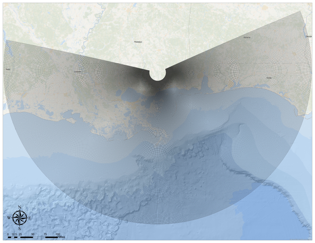
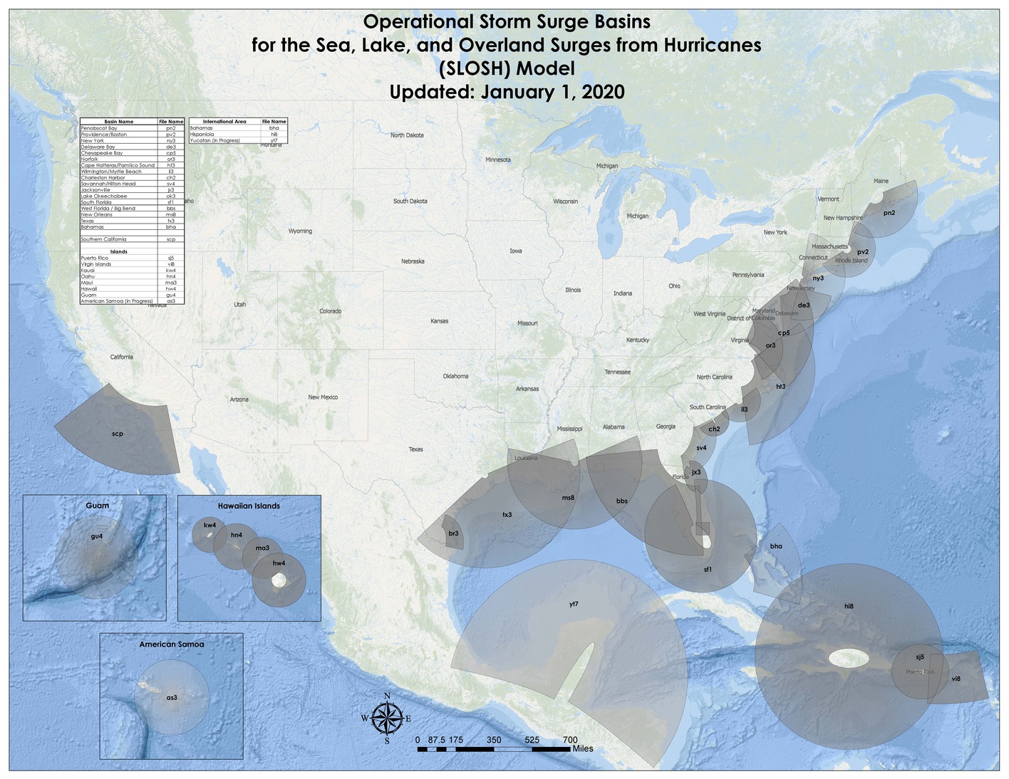
SLOSH has been applied to the entire U.S. Atlantic and Gulf of Mexico coastlines. In addition, coverage extends to Hawaii, Puerto Rico, Virgin Islands, and the Bahamas. The SLOSH model coverage is subdivided into 32 regions or basins. These basins are centered upon particularly susceptible features: inlets, large coastal centers of population, low-lying topography, and ports. An example of a typical computational domain, or basin, is the New Orleans basin.
SLOSH model coverage
Currently, SLOSH basins are being updated at an average rate of 3-6 basins per year. Priority for SLOSH basin updates are governed by the Interagency Coordinating Committee on Hurricanes (ICCOH). ICCOH is a tri-agency supported by the U.S. Army Corps of Engineers (USACE), Federal Emergency Management Agency (FEMA), and the National Oceanic and Atmospheric Administration (NOAA). ICCOH manages hazard and post-storm analysis for the Hurricane Evacuation Studies under the National Hurricane Program (NHP). Updates are driven by a number of different factors such as: changes to a basin's topography/bathymetry due to a landfalling hurricane, degree of vulnerability to storm surge, availability of new data, changes to the coast, and addition of engineered flood protection devices (e.g., levees).
Sometimes these updates include higher grid size resolution to improve surge representation, increasing area covered by hypothetical tracks for improved accuracy, and the latest topography or bathymetric data for better representation of barriers, gaps, passes, and other local features.
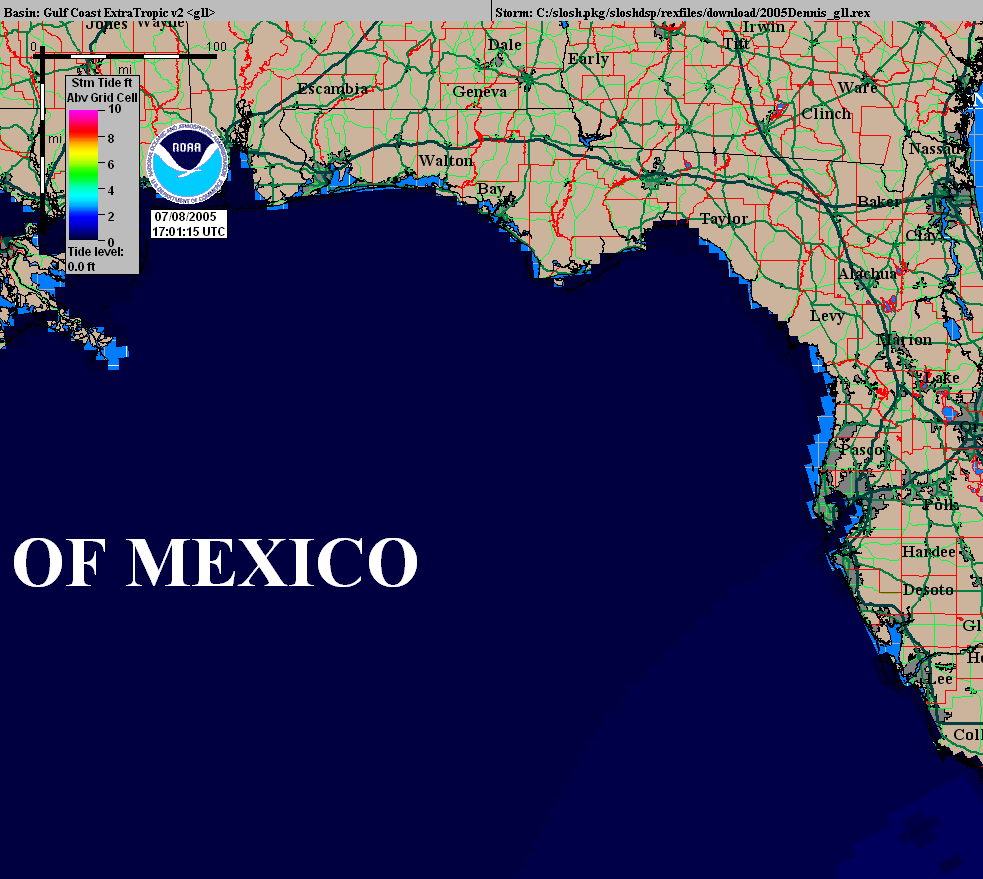
The SLOSH model is computationally efficient, resulting in fast computer runs which makes it an ideal operational system. It is able to resolve flow through barriers, gaps, and passes and models deep passes between bodies of water. It also resolves inland inundation and the overtopping of barrier systems, levees, and roads. It can resolve coastal reflections of surges such as coastally trapped Kelvin waves. Click here to see a Kelvin wave visible in the SLOSH Historical Run for Hurricane Dennis 2005. SLOSH also can explicitly model the astronomic tide, as well as provide different initial water level anomalies.
However, the SLOSH model does not explicitly model the impacts of waves on top of the surge nor does it account for normal river flow or rain flooding. Future advancements in the SLOSH model will allow for the resolution of some of these limitations.
HURREVAC is a web browser-based decision support tool that assists local and state emergency managers in HURRicane EVACuation planning, training, and timely decision making. This real‐time data analysis tool combines official NHC and NWS forecasts with USACE-generated Hurricane Evacuation Studies identifying vulnerable coastal populations and their evacuation clearance times under various storm scenarios. Information available within the program includes forecast track, timing, and wind speed; storm surge scenarios; evacuation timing; and more. HURREVAC is developed and maintained by the National Hurricane Program, which is administered by FEMA, in partnership with the USACE, and the NOAA National Hurricane Center. HURREVAC is available free of charge to government emergency managers.