NATIONAL HURRICANE CENTER and
CENTRAL PACIFIC HURRICANE CENTER

HOME | ARCHIVES | FORECASTS | IMAGERY | ABOUT NHC | RECONNAISSANCE

NHC Graphical Outlook Archive (Text)


« Earliest Available         ‹ Earlier         Later ›         Latest Available »
Place your mouse cursor over areas of interest for more information
Graphical TWO atl Click for Eastern Pacific

ZCZC MIATWOAT ALL
TTAA00 KNHC DDHHMM
TROPICAL WEATHER OUTLOOK
NWS TPC/NATIONAL HURRICANE CENTER MIAMI FL
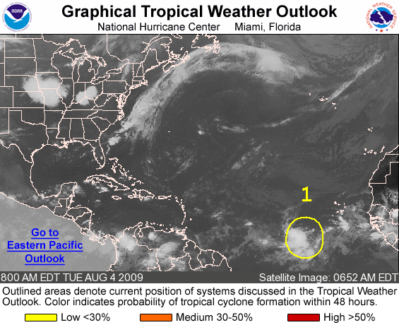
800 AM EDT TUE AUG 4 2009

FOR THE NORTH ATLANTIC...CARIBBEAN SEA AND THE GULF OF MEXICO...

1. AN AREA OF SHOWERS AND THUNDERSTORMS SEVERAL HUNDRED MILES SOUTHWEST
OF THE CAPE VERDE ISLANDS IS ASSOCIATED WITH A TROPICAL WAVE.  ANY
SIGNIFICANT DEVELOPMENT OF THE SYSTEM IS EXPECTED TO BE SLOW TO
OCCUR AS THIS WAVE MOVES TO WEST AT ABOUT 15 MPH.  

ELSEWHERE...TROPICAL CYCLONE FORMATION IS NOT EXPECTED DURING THE
NEXT 48 HOURS.

$$
FORECASTER BLAKE/PASCH
NNNN


List of all Atlantic Outlooks
List of all East Pacific Outlooks

Standard version of this page

Alternate Formats
About Alternates - E-Mail Advisories - RSS Feeds

Cyclone Forecasts
Latest Advisory - Past Advisories - About Advisories

Marine Forecasts
Latest Products - About Marine Products

Tools & Data
Satellite Imagery - US Weather Radar - Aircraft Recon - Local Data Archive - Forecast Verification - Deadliest/Costliest/Most Intense

Learn About Hurricanes
Storm Names Wind Scale - Prepare - Climatology - NHC Glossary - NHC Acronyms - Frequently Asked Questions - AOML Hurricane-Research Division

About Us
About NHC - Mission/Vision - Other NCEP Centers - NHC Staff - Visitor Information - NHC Library

Contact Us


NOAA/ National Weather Service
National Centers for Environmental Prediction
National Hurricane Center
11691 SW 17th Street
Miami, Florida, 33165-2149 USA
nhcwebmaster@noaa.gov

Disclaimer | Privacy Policy | Credits | About Us | Glossary | Career Opportunities