ZCZC MIATWOEP ALL
TTAA00 KNHC DDHHMM
Tropical Weather Outlook
NWS National Hurricane Center Miami FL
500 AM PDT Sun Aug 13 2023
For the eastern North Pacific...east of 140 degrees west longitude:
Active Systems:
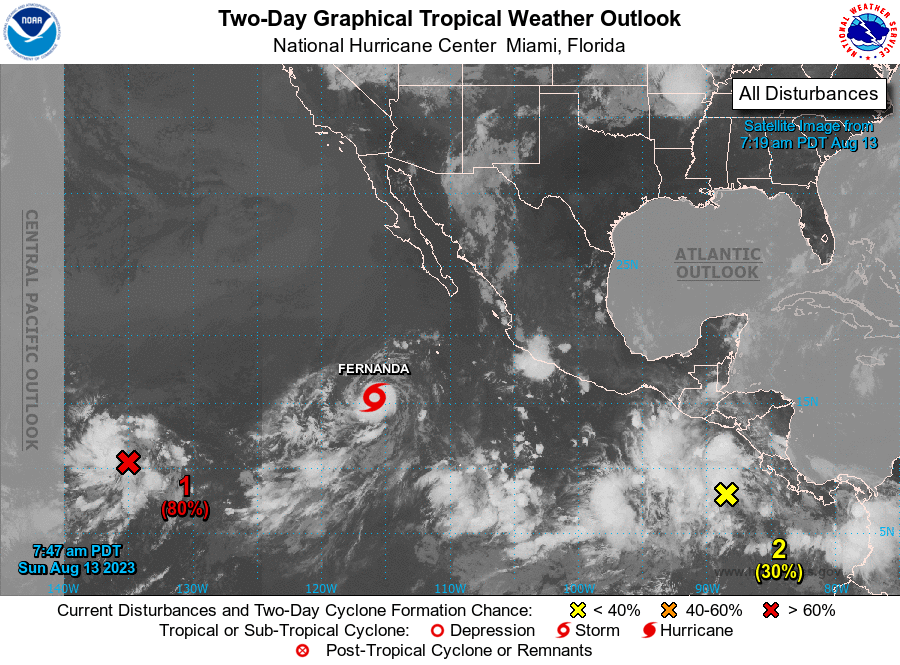
The National Hurricane Center is issuing advisories on Tropical
Storm Fernanda, located several hundred miles south-southwest of the
southern tip of the Baja California peninsula.
1. Western East Pacific (EP99):
Satellite wind data indicate the circulation associated with an area
of low pressure located about 1500 miles east-southeast of the
Hawaiian Islands is gradually becoming better defined. Although its
shower and thunderstorm activity remains disorganized, environmental
conditions appear conducive for further development of this system.
A tropical depression is likely to form within the next couple of
days as it moves westward or west-northwestward at about 10 mph over
the far western portion of the basin, and then crosses into the
Central Pacific basin late tonight.
* Formation chance through 48 hours...high...80 percent.
* Formation chance through 7 days...high...90 percent.
2. Off the Coast of Southern Mexico:
A tropical wave is producing a large area of disorganized showers
and thunderstorms over the far eastern portion of the east Pacific.
Environmental conditions appear conducive for development during the
next several days, and a tropical depression is expected to form by
midweek while the system moves generally west-northwestward, roughly
parallel to the coast of southern and southwestern Mexico.
* Formation chance through 48 hours...low...30 percent.
* Formation chance through 7 days...high...90 percent.
Public Advisories on Fernanda are issued under WMO header WTPZ32
KNHC and under AWIPS header MIATCPEP2.
Forecast/Advisories on Fernanda are issued under WMO header WTPZ22
KNHC and under AWIPS header MIATCMEP2.
Forecaster Reinhart