ZCZC HFOTWOCP ALL
TTAA00 PHFO DDHHMM
Tropical Weather Outlook
NWS Central Pacific Hurricane Center Honolulu HI
800 PM HST Fri Aug 11 2023
For the central North Pacific...between 140W and 180W:
Just West of the International Date Line:
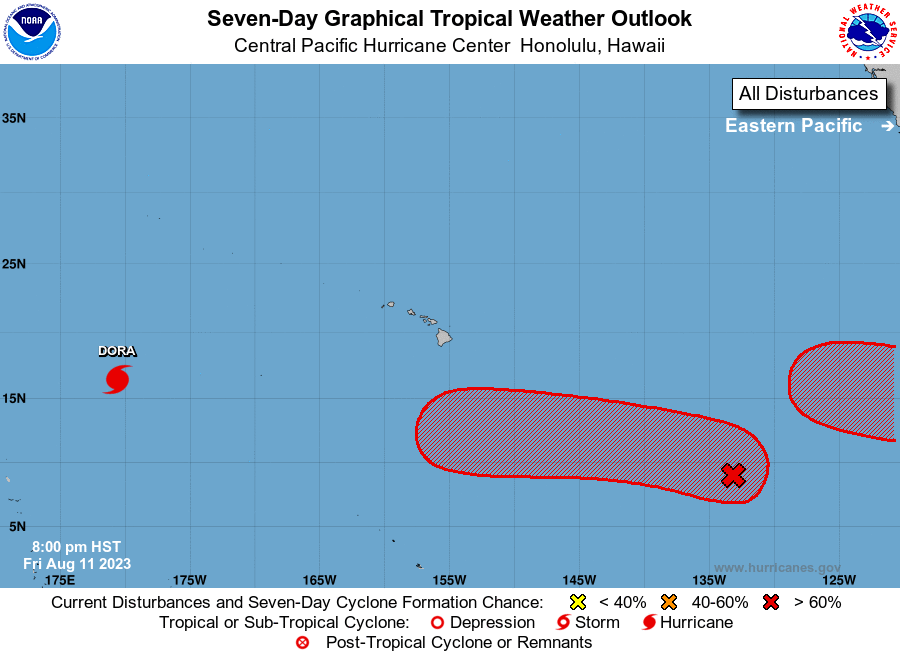
Bulletins for Typhoon Dora, which is about 1550 miles west-
southwest of Honolulu, Hawaii, are now being issued by RSMC
Tokyo, Japan. For U.S. interests, see Department of Defense
warnings issued by the Joint Typhoon Warning Center in Honolulu,
Hawaii.
1. Far east-southeast of the main Hawaiian Islands:
A broad area of low pressure associated with a tropical wave is
producing a large area of disorganized showers and thunderstorms
about 1650 miles east-southeast of Hilo, Hawaii. Conditions appear
conducive for development of this system, and a tropical depression
is likely to form during the next few days while moving toward the
west or west-northwest at about 10 mph across the far western
portion of the eastern Pacific basin, crossing into the Central
Pacific basin on Sunday.
* Formation chance through 48 hours...medium...near 40 percent.
* Formation chance through 7 days...high...70 percent.
2. Central East Pacific (EP98):
Showers and thunderstorms are showing signs of organization in
association with an area of low pressure located about 2900 miles
east-southeast of Hilo, Hawaii. Environmental conditions are
conducive for development of this system, and a tropical depression
is likely to form late this weekend or early next week while it
moves westward or northwestward at about 10 mph across the central
portion of the eastern Pacific basin. This system, if it develops,
may cross into the Central Pacific basin in about a week.
* Formation chance through 48 hours...medium...60 percent.
* Formation chance through 7 days...high...80 percent.
Elsewhere, no tropical cyclones are expected during the next 7 days.
Forecaster Houston