ZCZC MIATWOAT ALL
TTAA00 KNHC DDHHMM
Tropical Weather Outlook
NWS National Hurricane Center Miami FL
100 AM EST Thu Nov 16 2023
For the North Atlantic...Caribbean Sea and the Gulf of Mexico:
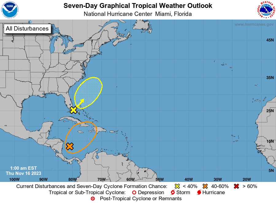
Southwestern Caribbean Sea (AL98):
A broad area of low pressure over the southwestern Caribbean Sea
continues to produce a large area of disorganized showers and
thunderstorms. Environmental conditions appear marginally
conducive for development of this system over the next day or two,
and a tropical depression could form by this weekend as the system
moves northeastward across the western and central part of the
Caribbean Sea. An Air Force Reserve reconnaissance aircraft is
scheduled to investigate the system later today.
1. Regardless of development, this system is expected to produce heavy
rains that could result in flash flooding and mudslides over
portions of the Caribbean coast of Central America and the Greater
Antilles through this weekend. Interests in Jamaica, Cuba, Haiti,
the Dominican Republic, the southeastern Bahamas, and the Turks and
Caicos Islands should continue to monitor the progress of this
system.
* Formation chance through 48 hours...medium...50 percent.
* Formation chance through 7 days...medium...50 percent.
2. Offshore Southeast Coast of United States:
A non-tropical area of low pressure has formed near southern Florida
along a frontal boundary. This system is forecast to move quickly
northeastward across the Bahamas and offshore of the east coast of
the U.S. through the weekend. Although development into a tropical
cyclone appears unlikely, this system is expected to continue to
produce gusty winds and heavy rains across portions of southern
Florida, the Florida Keys, and the Bahamas during the next day or
so. For more information on this system, including gale warnings,
see High Seas Forecasts issued by the National Weather Service.
* Formation chance through 48 hours...low...10 percent.
* Formation chance through 7 days...low...10 percent.
High Seas Forecasts issued by the National Weather Service
can be found under AWIPS header NFDHSFAT1, WMO header FZNT01
KWBC, and online at ocean.weather.gov/shtml/NFDHSFAT1.php
Forecaster Cangialosi