ZCZC MIATWOAT ALL
TTAA00 KNHC DDHHMM CCA
Special Tropical Weather Outlook...Corrected
NWS National Hurricane Center Miami FL
1000 AM EDT Thu Sep 21 2023
Corrrected time in the product
For the North Atlantic...Caribbean Sea and the Gulf of Mexico:
Special outlook issued to raise probabilities and update discussion
Active Systems:
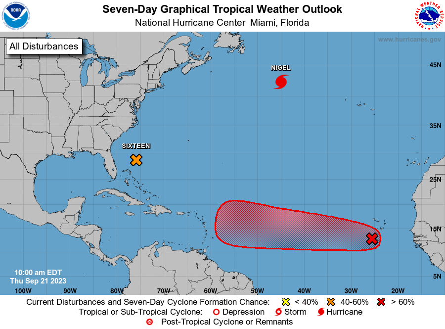
The National Hurricane Center is issuing advisories on Hurricane
Nigel, located over the central subtropical Atlantic.
1. Off the Southeastern United States Coast (AL99):
Updated...A trough of low pressure located several hundred miles
east of the Florida peninsula continues to produce a large area of
disorganized showers and thunderstorms. A non-tropical low pressure
system is expected to form within this area by early Friday, and
there are increasing chances that this system could acquire some
tropical or subtropical characteristics on Friday or early Saturday
while it moves generally northward toward the coast of North
Carolina. Regardless of tropical or subtropical development, this
low is likely to bring tropical storm force winds, heavy rain,
coastal flooding, and high surf to portions of the southeast and
mid-Atlantic United States coastline on Friday and into the
weekend. Tropical Storm watches or warnings could be required for
this system as soon as later this morning. Additional information on
this system, including storm and gale warnings, can be found in High
Seas Forecasts and products from your local National Weather Service
office.
* Formation chance through 48 hours...medium...50 percent.
* Formation chance through 7 days...medium...50 percent.
2. Eastern Tropical Atlantic:
A tropical wave located just west of the Cabo Verde Islands is
producing some disorganized shower and thunderstorm activity.
Environmental conditions are forecast to be conducive for gradual
development of this system, and a tropical depression is likely to
form this weekend or early next week while the system moves
generally westward at 10 to 15 mph across the eastern and central
tropical Atlantic.
* Formation chance through 48 hours...low...20 percent.
* Formation chance through 7 days...high...70 percent.
High Seas Forecasts issued by the National Weather Service
can be found under AWIPS header NFDHSFAT1, WMO header FZNT01
KWBC, and online at ocean.weather.gov/shtml/NFDHSFAT1.php
Forecaster Reinhart/Brown