ZCZC MIATWOAT ALL
TTAA00 KNHC DDHHMM
Tropical Weather Outlook
NWS National Hurricane Center Miami FL
200 AM EDT Thu Sep 7 2023
For the North Atlantic...Caribbean Sea and the Gulf of Mexico:
Active Systems:
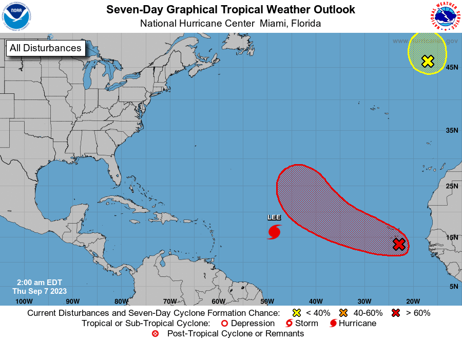
The National Hurricane Center is issuing advisories on Hurricane
Lee, located over the central tropical Atlantic.
1. Eastern Tropical Atlantic (AL96):
Showers and thunderstorms are showing signs of organization in
association with a broad area of low pressure located over the
eastern tropical Atlantic near the Cabo Verde Islands.
Environmental conditions are expected to be generally conducive for
additional development, and a tropical depression is likely to form
during the next couple of days while the disturbance moves toward
the west-northwest at about 15 mph. Heavy rains and gusty winds
associated with this system are now occurring over the Cabo Verde
Islands, and these conditions are expected to continue during the
next several hours.
* Formation chance through 48 hours...medium...60 percent.
* Formation chance through 7 days...high...80 percent.
2. Northeastern Atlantic (ex-Franklin):
Shower and thunderstorm activity associated with Post-Tropical
Cyclone Franklin, located a few hundred miles west-northwest of the
northwestern coast of Spain, have not become better organized and
the system remains frontal. The system could briefly acquire some
subtropical or tropical characteristics later today while it moves
northward and then meanders northwest of Spain and Portugal, but
environmental conditions appear to become unfavorable for further
development by tonight. For additional information, including gale
warnings, see High Seas Forecasts issued by Meteo France.
* Formation chance through 48 hours...low...20 percent.
* Formation chance through 7 days...low...20 percent.
Additional information on Post-Tropical Cyclone Franklin can be
found in High Seas Forecasts issued by Meteo France under WMO header
FQNT50 LFPW and online at
www.meteofrance.com/previsions-meteo-marine/bulletin/grandlarge/
metarea2
Forecaster Cangialosi