ZCZC MIATWOAT ALL
TTAA00 KNHC DDHHMM
Tropical Weather Outlook
NWS National Hurricane Center Miami FL
800 PM EDT Wed Sep 6 2023
For the North Atlantic...Caribbean Sea and the Gulf of Mexico:
Active Systems:
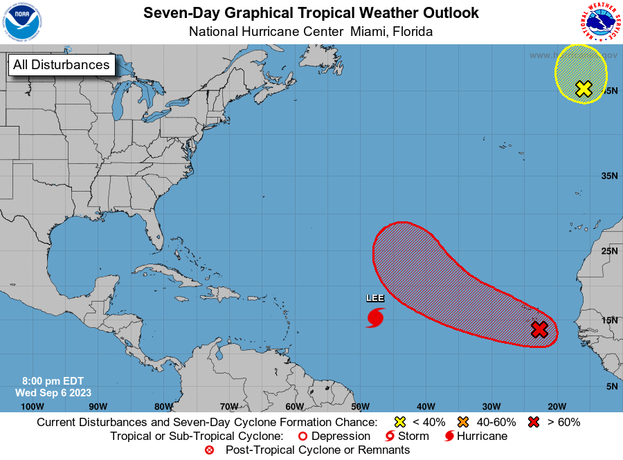
The National Hurricane Center is issuing advisories on Tropical
Storm Lee, located over the central tropical Atlantic.
1. Eastern Tropical Atlantic (AL96):
A broad area of low pressure, associated with a tropical wave, is
producing disorganized showers and thunderstorms over the far
eastern Atlantic, which are beginning to spread over the Cabo Verde
Islands. Environmental conditions appear conducive for gradual
development of this system, and a tropical depression is likely to
form later this week while moving toward the west-northwest at about
15 mph over the eastern and central tropical Atlantic. The low is
expected to move across the Cabo Verde Islands overnight and early
Thursday, and interests there should monitor its progress.
* Formation chance through 48 hours...medium...40 percent.
* Formation chance through 7 days...high...70 percent.
2. Northeastern Atlantic (ex-Franklin):
Shower and thunderstorm activity associated with Post-Tropical
Cyclone Franklin, located a few hundred miles west-northwest of the
northwestern coast of Spain, has changed little in organization
today. This system could briefly acquire some subtropical or
tropical characteristics while it moves northward and then meanders
northwest of Spain and Portugal overnight and on Thursday, but
environmental conditions appear to become unfavorable for further
development by Thursday night. For additional information,
including gale warnings, see High Seas Forecasts issued by Meteo
France.
* Formation chance through 48 hours...low...30 percent.
* Formation chance through 7 days...low...30 percent.
Additional information on Post-Tropical Cyclone Franklin can be
found in High Seas Forecasts issued by Meteo France under WMO header
FQNT50 LFPW and online at
www.meteofrance.com/previsions-meteo-marine/bulletin/grandlarge/
metarea2
Forecaster Berg