ZCZC MIATWOAT ALL
TTAA00 KNHC DDHHMM
Tropical Weather Outlook
NWS National Hurricane Center Miami FL
Issued by the NWS Weather Prediction Center College Park MD
200 PM EDT Wed Sep 6 2023
For the North Atlantic...Caribbean Sea and the Gulf of Mexico:
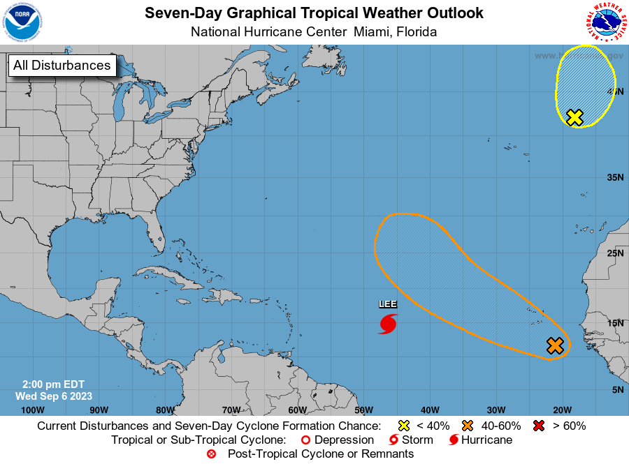
Active Systems:
The National Hurricane Center is issuing advisories on Tropical
Storm Lee, located over the central tropical Atlantic.
1. Eastern Tropical Atlantic (AL96):
A tropical wave is producing a large area of disorganized showers
and thunderstorms over the far eastern Atlantic between the Cabo
Verde Islands and the west coast of Africa. Environmental
conditions appear conducive for some gradual development of this
system, and a tropical depression could form later this week or this
weekend while the system moves west-northwestward at 10 to 15 mph
over the eastern tropical Atlantic. This system is expected to move
across the Cabo Verde Islands today and tonight, and interests there
should monitor its progress.
* Formation chance through 48 hours...low...30 percent.
* Formation chance through 7 days...medium...60 percent.
2. Northeastern Atlantic (ex-Franklin):
Shower and thunderstorm activity associated with Post-Tropical
Cyclone Franklin, located a few hundred miles east-northeast of the
Azores, has become a little better organized today. Although
environmental conditions are only marginally favorable for
additional development this system could briefly acquire some
subtropical or tropical characteristics during the next day or so,
while it moves northeastward or northward over the northeastern
Atlantic. By Friday, further development is not expected as the
system is forecast to move into unfavorable environmental
conditions, which should cause it to weaken. For additional
information, including gale warnings, see High Seas Forecasts issued
by Meteo France.
* Formation chance through 48 hours...low...30 percent.
* Formation chance through 7 days...low...30 percent.
Additional information on Post-Tropical Cyclone Franklin can be
found in High Seas Forecasts issued by Meteo France under WMO header
FQNT50 LFPW and online at
www.meteofrance.com/previsions-meteo-marine/bulletin/grandlarge/
metarea2
Forecaster Kelly/Brown