ZCZC MIATWOAT ALL
TTAA00 KNHC DDHHMM
Tropical Weather Outlook
NWS National Hurricane Center Miami FL
800 AM EDT Fri Sep 1 2023
For the North Atlantic...Caribbean Sea and the Gulf of Mexico:
Active Systems:
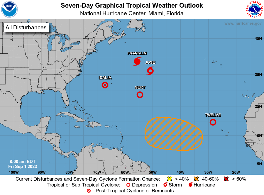
The National Hurricane Center is issuing advisories on Hurricane
Franklin, located several hundred miles northeast of Bermuda, on
Post-Tropical Cyclone Idalia, located a few hundred miles west of
Bermuda, on Tropical Storm Jose, located several hundred miles
east-northeast of Bermuda, and has resumed advisories on Tropical
Depression Gert, located several hundred miles east-southeast of
Bermuda.
1. Eastern Tropical Atlantic (AL94):
Recent microwave satellite images indicate the circulation of a low
pressure system located west-northwest of the Cabo Verde Islands has
become better defined since yesterday. In addition, the associated
shower and thunderstorm activity continues to show signs of
organization. Based on these trends, advisories are likely to be
initiated on a tropical depression or tropical storm later this
morning. The system is moving northwestward at 10 to 15 mph across
the eastern tropical Atlantic.
* Formation chance through 48 hours...high...near 100 percent.
* Formation chance through 7 days...high...near 100 percent.
2. Eastern and Central Tropical Atlantic:
A tropical wave is expected to move off the west coast of Africa
this weekend. Environmental conditions appear conducive for some
gradual development of this system during the early and middle
parts of next week, and a tropical depression could form while it
moves westward to west-northwestward over the eastern and central
portions of the tropical Atlantic.
* Formation chance through 48 hours...low...near 0 percent.
* Formation chance through 7 days...medium...50 percent.
Public Advisories on Gert are issued under WMO header WTNT32 KNHC
and under AWIPS header MIATCPAT2.
Forecast/Advisories on Gert are issued under WMO header WTNT22 KNHC
and under AWIPS header MIATCMAT2.
Forecaster Reinhart