ZCZC MIATWOAT ALL
TTAA00 KNHC DDHHMM
Tropical Weather Outlook
NWS National Hurricane Center Miami FL
800 PM EDT Thu Aug 31 2023
For the North Atlantic...Caribbean Sea and the Gulf of Mexico:
Active Systems:
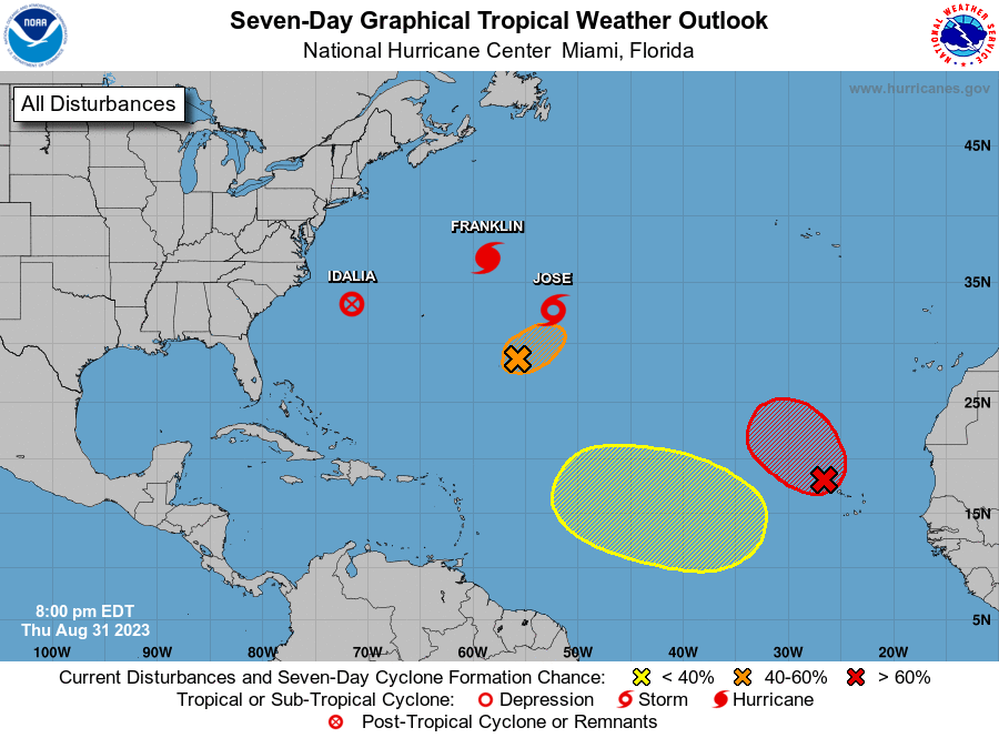
The National Hurricane Center is issuing advisories on Hurricane
Franklin, located a few hundred miles northeast of Bermuda, on
Post-Tropical Cyclone Idalia, located off the coast of North
Carolina, and on Tropical Storm Jose, located several hundred miles
east of Bermuda.
1. Eastern Tropical Atlantic (AL94):
Showers and thunderstorms continue to show signs of organization in
association with an elongated area of low pressure located just
west of the Cabo Verde Islands. A short-lived tropical depression
or tropical storm is expected to form later tonight or on Friday
while the system moves northwestward at 10 to 15 mph across the
eastern tropical Atlantic.
* Formation chance through 48 hours...high...90 percent.
* Formation chance through 7 days...high...90 percent.
2. Central Subtropical Atlantic (Remnants of Gert):
A small area of low pressure located several hundred miles
north-northeast of the northern Leeward Islands is producing small
bursts of showers and thunderstorms to the south of its center. This
system has a short window to become a tropical depression during the
next day or so while it drifts northeastward or eastward, before
upper-level winds become increasingly unfavorable by the weekend.
* Formation chance through 48 hours...medium...40 percent.
* Formation chance through 7 days...medium...40 percent.
3. Eastern and Central Tropical Atlantic:
A tropical wave is expected to move off the west coast of Africa
this weekend. Environmental conditions could support some gradual
development of this system through the middle part of next week
while it moves westward to west-northwestward over the eastern and
central portions of the tropical Atlantic.
* Formation chance through 48 hours...low...near 0 percent.
* Formation chance through 7 days...low...30 percent.
Forecaster Bucci/Cangialosi