ZCZC MIATWOAT ALL
TTAA00 KNHC DDHHMM
Tropical Weather Outlook
NWS National Hurricane Center Miami FL
200 PM EDT Sat Aug 26 2023
For the North Atlantic...Caribbean Sea and the Gulf of Mexico:
Active Systems:
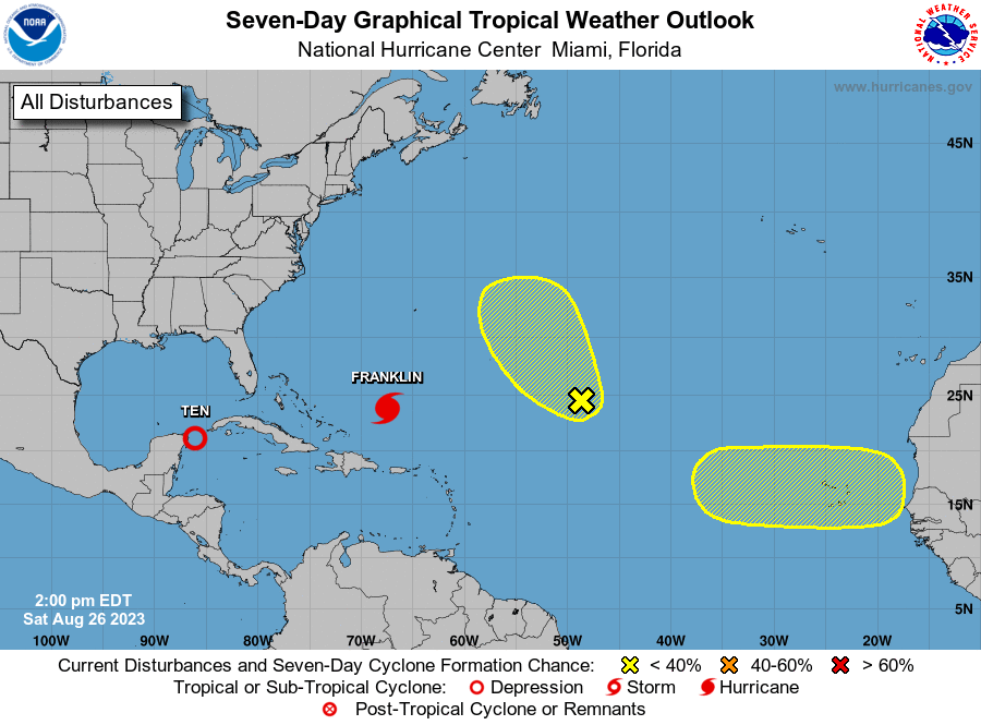
The National Hurricane Center is issuing advisories on recently
upgraded Hurricane Franklin, located several hundred miles south of
Bermuda.
1. Northwestern Caribbean Sea and Eastern Gulf of Mexico (AL93):
Showers and thunderstorms associated with an area of low pressure
located near the Yucatan Channel continue to gradually become
better organized. If this trend continues, advisories will be
initiated on this system later today. The system is expected to
move very slowly northward into the southeastern Gulf of Mexico
during the next couple of days. Heavy rains are likely over
portions of western Cuba and the Yucatan Peninsula of Mexico.
Interests in the Yucatan Peninsula of Mexico, western Cuba, and
Florida should monitor the progress of this system.
* Formation chance through 48 hours...high...90 percent.
* Formation chance through 7 days...high...90 percent.
2. Central Tropical Atlantic (AL92):
Disorganized showers and thunderstorms continue in association with
a broad area of low pressure located about 1000 miles
east-northeast of the northern Leeward Islands. This system has
not become better organized since yesterday, and development is
becoming less likely while it moves generally northwestward over
the central subtropical Atlantic.
* Formation chance through 48 hours...low...20 percent.
* Formation chance through 7 days...low...30 percent.
3. Eastern Tropical Atlantic:
A tropical wave is forecast to move off the west coast of Africa
early next week. Some slow development of this system is possible
during the latter part of next week while the system moves westward
across the eastern tropical Atlantic.
* Formation chance through 48 hours...low...near 0 percent.
* Formation chance through 7 days...low...20 percent.
Forecaster Pasch