ZCZC MIATWOAT ALL
TTAA00 KNHC DDHHMM
Tropical Weather Outlook
NWS National Hurricane Center Miami FL
800 AM EDT Sat Aug 26 2023
For the North Atlantic...Caribbean Sea and the Gulf of Mexico:
Active Systems:
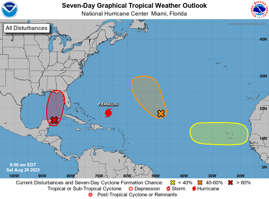
The National Hurricane Center is issuing advisories on Tropical
Storm Franklin, located several hundred miles south of Bermuda.
1. Northwestern Caribbean Sea and Eastern Gulf of Mexico (AL93):
Shower and thunderstorm activity continues to show signs of
organization in association with an area of low pressure located
near the Yucatan Channel. Environmental conditions appear conducive
for further development of this system, and a tropical depression is
likely to form within the next day or two while it moves generally
northward over the southeastern Gulf of Mexico. Interests in the
Yucatan Peninsula of Mexico, western Cuba, and Florida should
monitor the progress of this system.
* Formation chance through 48 hours...high...70 percent.
* Formation chance through 7 days...high...90 percent.
2. Central Tropical Atlantic (AL92):
Disorganized showers and thunderstorms continue in association with
a broad area of low pressure located about 1000 miles
east-northeast of the northern Leeward Islands. Environmental
conditions could become more conducive for development over the
next few days, and a tropical depression could form early next week
while the system moves generally northwestward over the central
subtropical Atlantic.
* Formation chance through 48 hours...low...20 percent.
* Formation chance through 7 days...medium...40 percent.
3. Eastern Tropical Atlantic:
A tropical wave is forecast to move off the west coast of Africa
early next week. Some slow development of this system is possible
during the latter part of next week while the system moves westward
across the eastern tropical Atlantic.
* Formation chance through 48 hours...low...near 0 percent.
* Formation chance through 7 days...low...20 percent.
Forecaster Pasch