ZCZC MIATWOAT ALL
TTAA00 KNHC DDHHMM
Tropical Weather Outlook
NWS National Hurricane Center Miami FL
800 AM EDT Fri Aug 25 2023
For the North Atlantic...Caribbean Sea and the Gulf of Mexico:
Active Systems:
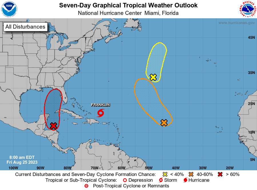
The National Hurricane Center is issuing advisories on Tropical
Storm Franklin, located a couple of hundred miles east-northeast of
the Turks and Caicos Islands.
1. Northwestern Caribbean Sea and eastern Gulf of Mexico:
A broad area of low pressure over the northwestern Caribbean Sea is
producing disorganized showers and thunderstorms. Environmental
conditions appear conducive for gradual development of this system
during the next several days, and a tropical depression is likely to
form late this weekend or early next week while moving generally
northward over the northwestern Caribbean Sea and eastern Gulf of
Mexico. Interests in the Yucatan Peninsula of Mexico, western Cuba,
and Florida should monitor the progress of this system.
* Formation chance through 48 hours...low...30 percent.
* Formation chance through 7 days...high...70 percent.
2. Central Subtropical Atlantic (Remnants of Emily):
A trough of low pressure located roughly 1000 miles east-northeast
of Bermuda (the remnants of former Tropical Storm Emily) is
producing an elongated area of disorganized showers and
thunderstorms. Environmental conditions are becoming less
favorable for tropical cyclone formation, and the low is expected
to merge with a frontal boundary over the north central Atlantic in
the next day or so. For additional information on this system,
including gale warnings, see High Seas Forecasts issued by the
National Weather Service.
* Formation chance through 48 hours...low...20 percent.
* Formation chance through 7 days...low...20 percent.
3. Central Tropical Atlantic (AL92):
Disorganized showers and thunderstorms continue in association with
an area of low pressure located about midway between the Cabo Verde
Islands and the northern Leeward Islands. Environmental conditions
could become more conducive for development this weekend, and a
tropical depression could form by early next week while the system
moves generally northwestward toward the central subtropical
Atlantic.
* Formation chance through 48 hours...low...20 percent.
* Formation chance through 7 days...medium...50 percent.
High Seas Forecasts issued by the National Weather Service can be
found under AWIPS header NFDHSFAT1, WMO header FZNT01 KWBC, and
online at ocean.weather.gov/shtml/NFDHSFAT1.php
Forecaster Kelly/Blake