ZCZC MIATWOAT ALL
TTAA00 KNHC DDHHMM
Tropical Weather Outlook
NWS National Hurricane Center Miami FL
200 PM EDT Wed Aug 23 2023
For the North Atlantic...Caribbean Sea and the Gulf of Mexico:
Active Systems:
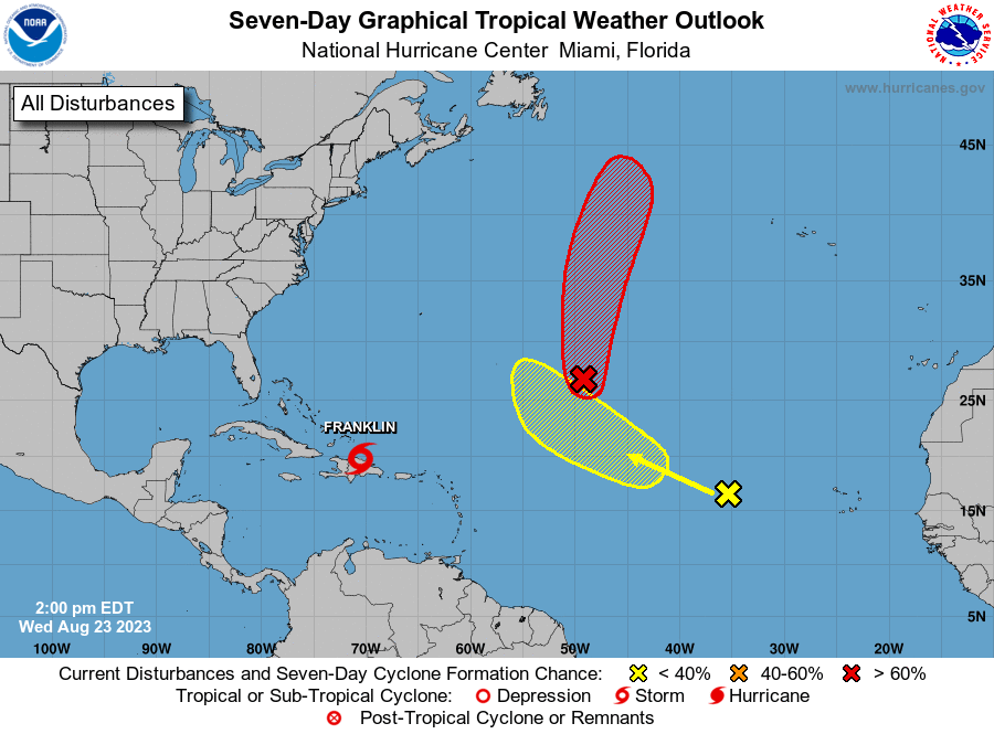
The National Hurricane Center is issuing advisories on Tropical
Storm Franklin, located inland over the Dominican Republic. The
Weather Prediction Center has issued the final advisory on
Post-Tropical Cyclone Harold, located inland over northern Mexico.
1. Central Subtropical Atlantic (Remnants of Emily):
An area of low pressure more than 1000 miles miles northeast of the
Leeward Islands (the remnants of former Tropical Storm Emily)
continues to produce a large area of disorganized showers and
thunderstorms northeast of its center. Upper-level winds are
forecast to become more conducive for development by tomorrow, and
this system is likely to regenerate into a tropical depression or
tropical storm late this week or this weekend when the system moves
northward over the subtropical central Atlantic. For additional
information on this system, including gale warnings, see High Seas
Forecasts issued by the National Weather Service.
* Formation chance through 48 hours...medium...60 percent.
* Formation chance through 7 days...high...70 percent.
2. Eastern Tropical Atlantic (AL92):
Disorganized showers and thunderstorms continue in association with
an area of low pressure located several hundred miles west of the
Cabo Verde Islands. Environmental conditions appear only marginally
favorable for some slow development through early next week while
the system moves west-northwestward to northwestward into the
central tropical Atlantic.
* Formation chance through 48 hours...low...10 percent.
* Formation chance through 7 days...low...30 percent.
Information on Post-Tropical Cyclone Harold can be found in Public
Advisories issued by the Weather Prediction Center, under AWIPS
header TCPAT4, WMO header WTNT34 KWNH, and on the web at
www.hurricanes.gov.
High Seas Forecasts issued by the National Weather Service can be
found under AWIPS header NFDHSFAT1, WMO header FZNT01 KWBC, and
online at ocean.weather.gov/shtml/NFDHSFAT1.php
Forecaster Papin/R. Zelinsky