ZCZC MIATWOAT ALL
TTAA00 KNHC DDHHMM
Tropical Weather Outlook
NWS National Hurricane Center Miami FL
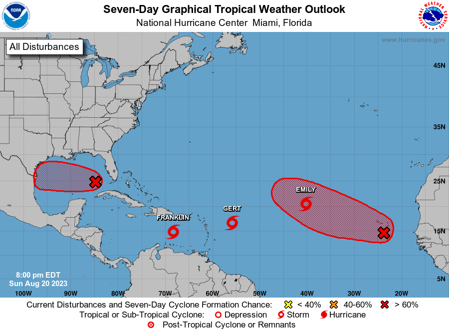
800 PM EDT Sun Aug 20 2023
For the North Atlantic...Caribbean Sea and the Gulf of Mexico:
Active Systems:
The National Hurricane Center is issuing advisories on Tropical
Depression Six, located several hundred miles east of the northern
Leeward Islands, on Tropical Storm Emily, located about 1000 miles
west-northwest of the Cabo Verde Islands, and on newly formed
Tropical Storm Franklin, located over the eastern Caribbean Sea.
1. Western Gulf of Mexico (AL91):
Showers and thunderstorms have increased this evening, and are
becoming better organized in association with a trough of low
pressure located in the eastern Gulf of Mexico. Environmental
conditions appear favorable for development of this system as it
moves westward at about 15 to 20 mph across the central Gulf of
Mexico. A tropical depression or storm is likely to form as it
approaches the western Gulf of Mexico coastline by Tuesday.
Interests in the western Gulf of Mexico should monitor the progress
of this system. Tropical storm watches or warnings may be necessary
on Monday for portions of the southern Texas and northern Mexico
coastlines.
* Formation chance through 48 hours...high...70 percent.
* Formation chance through 7 days...high...70 percent.
2. Eastern Tropical Atlantic:
A large area of disorganized showers and thunderstorms over the
far eastern tropical Atlantic is associated with a tropical wave
located near the Cabo Verde Islands. Environmental conditions appear
conducive for gradual development of this system, and a tropical
depression is likely to form later this week while it moves
west-northwestward across the eastern tropical Atlantic.
* Formation chance through 48 hours...low...30 percent.
* Formation chance through 7 days...high...70 percent.
Public Advisories on Tropical Storm Emily are issued under WMO
header WTNT32 KNHC and under AWIPS header MIATCPAT2.
Forecast/Advisories on Tropical Storm Emily are issued under WMO
header WTNT22 KNHC and under AWIPS header MIATCMAT2.
Public Advisories on Tropical Storm Franklin are issued under WMO
header WTNT33 KNHC and under AWIPS header MIATCPAT3.
Forecast/Advisories on Tropical Storm Franklin are issued under WMO
header WTNT23 KNHC and under AWIPS header MIATCMAT3.
Forecaster Kelly/Brown