ZCZC MIATWOAT ALL
TTAA00 KNHC DDHHMM
Tropical Weather Outlook
NWS National Hurricane Center Miami FL
200 PM EDT Sun Aug 20 2023
For the North Atlantic...Caribbean Sea and the Gulf of Mexico:
Active Systems:
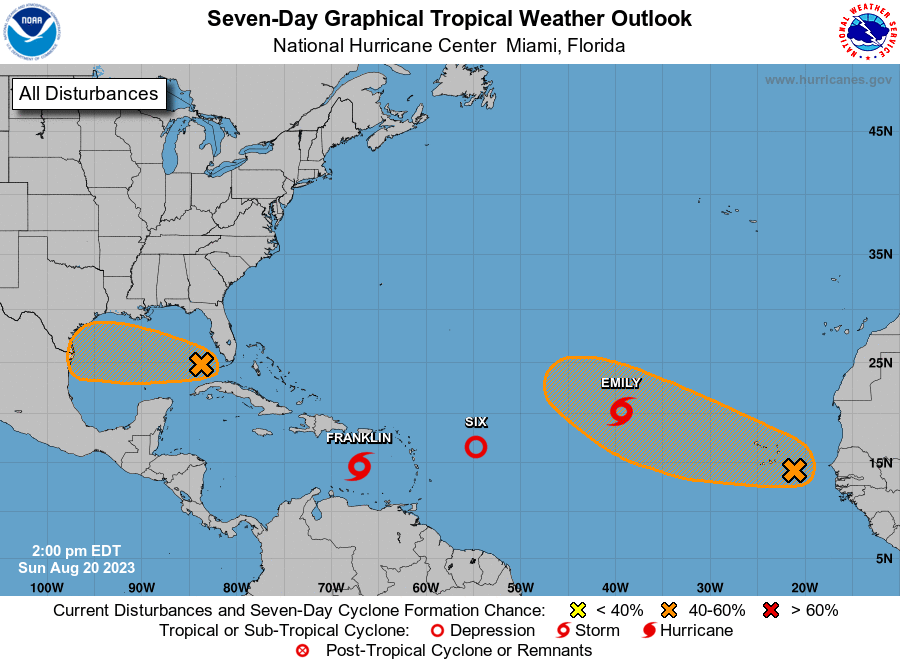
The National Hurricane Center is issuing advisories on Tropical
Depression Six, located several hundred miles east of the northern
Leeward Islands and on newly formed Tropical Storm Emily, located
about 1000 miles west-northeast of the Cabo Verde Islands.
1. Eastern Caribbean (AL90):
Showers and thunderstorms continue to show signs of organization in
association with an area of low pressure over the eastern Caribbean
Sea. In addition, visible satellite imagery shows evidence that a
well-defined center is developing, and earlier satellite wind data
indicated the system was producing winds of 35-40 mph. If these
trends continue, a tropical depression or storm could form as soon
as later this afternoon. A NOAA Hurricane Reconnaissance mission is
currently en route to investigate the system this afternoon. The
system is forecast to move westward to west-northwestward at 10 to
15 mph over the eastern and central Caribbean, before turning
northward and potentially affecting the Dominican Republic and Haiti
on Tuesday or Wednesday, where tropical storm watches could become
necessary later this afternoon. Regardless of development, heavy
rainfall is possible over portions of the Lesser Antilles during the
next couple of days. Interests in the eastern and central Caribbean
should monitor the progress of this system.
* Formation chance through 48 hours...high...90 percent.
* Formation chance through 7 days...high...90 percent.
2. Western Gulf of Mexico (AL91):
Showers and thunderstorms have increased this afternoon in
association with an area of disturbed weather located in the eastern
Gulf of Mexico. Additional development of this system is possible as
it moves westward at about 15 to 20 mph, and a tropical depression
could form as it approaches the western Gulf of Mexico coastline by
Tuesday.
* Formation chance through 48 hours...medium...50 percent.
* Formation chance through 7 days...medium...60 percent.
3. Eastern Tropical Atlantic:
A large area of disorganized showers and thunderstorms over the far
eastern tropical Atlantic is associated with a tropical wave
centered just southeast of the Cabo Verde Islands. Environmental
conditions appear conducive for gradual development of this system,
and a tropical depression could form later this week while it moves
west-northwestward across the eastern tropical Atlantic.
* Formation chance through 48 hours...low...20 percent.
* Formation chance through 7 days...medium...60 percent.
Public Advisories on Tropical Depression Six are issued under WMO
header WTNT31 KNHC and under AWIPS header MIATCPAT1.
Forecast/Advisories on Tropical Depression Six are issued under WMO
header WTNT21 KNHC and under AWIPS header MIATCMAT1.
Public Advisories on Tropical Storm Emily are issued under WMO
header WTNT32 KNHC and under AWIPS header MIATCPAT2.
Forecast/Advisories on Tropical Storm Emily are issued under WMO
header WTNT22 KNHC and under AWIPS header MIATCMAT2.
Forecaster Papin/Cangialosi/Hogsett