ZCZC MIATWOAT ALL
TTAA00 KNHC DDHHMM
Tropical Weather Outlook
NWS National Hurricane Center Miami FL
800 AM EDT Sun Aug 20 2023
For the North Atlantic...Caribbean Sea and the Gulf of Mexico:
Active Systems:
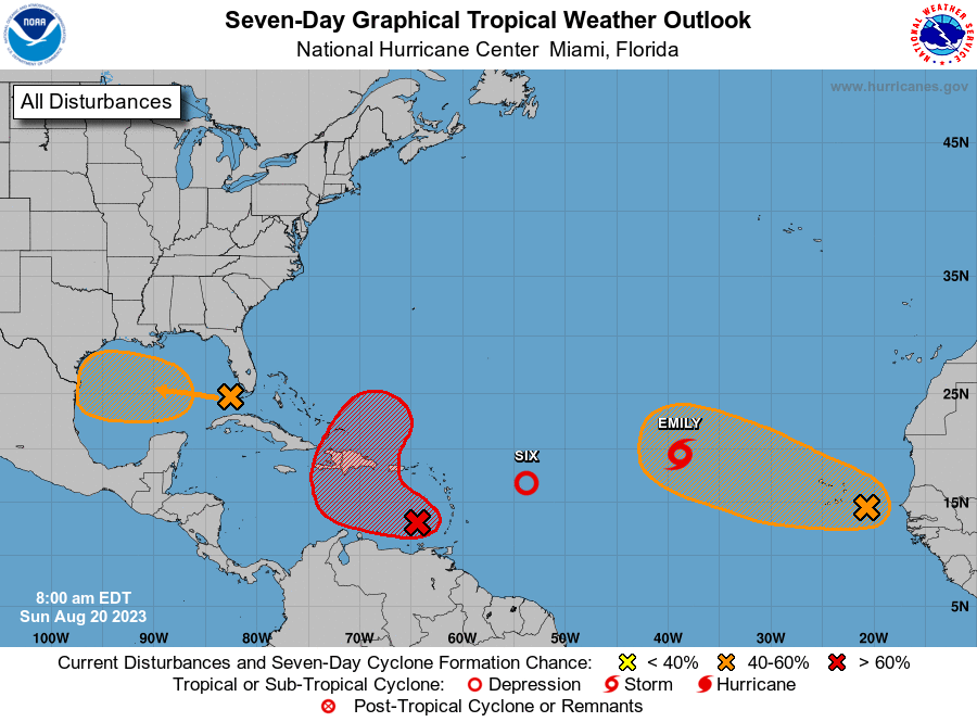
The National Hurricane Center is issuing advisories on Tropical
Depression Six, located several hundred miles east of the northern
Leeward Islands.
1. Central Tropical Atlantic (AL98):
Showers and thunderstorms continue to show signs of organization in
association with an area of low pressure located several hundred
miles west-northwest of the Cabo Verde Islands. Earlier satellite
wind data indicated the system was producing winds up to 40 mph on
its north side. In addition, first light visible satellite suggests
the center may be becoming better defined. If these current trends
continue, a short-lived tropical depression or tropical storm is
likely to form later today or tonight while it moves
west-northwestward at about 10 mph over the central tropical
Atlantic. By Monday, upper-level winds are forecast to strengthen
over the system, and further development is not expected. For
additional information on this system, including gale warnings, see
High Seas Forecasts issued by the National Weather Service.
* Formation chance through 48 hours...high...80 percent.
* Formation chance through 7 days...high...80 percent.
2. Eastern Caribbean (AL90):
Showers and thunderstorms continue to show signs of organization in
association with an area of low pressure over the far eastern
Caribbean Sea. Additional development of this system is expected,
and a tropical depression is likely to form during the next couple
of days as it moves westward to west-northwestward at 10 to 15 mph
over the eastern and central Caribbean, before turning northward and
moving into the southwestern Atlantic Ocean by midweek. Regardless
of development, heavy rainfall is possible over portions of the
Lesser Antilles during the next couple of days. Interests in the
eastern and central Caribbean should monitor the progress of this
system. A NOAA Hurricane Reconnaissance mission is scheduled to
investigate the system later today.
* Formation chance through 48 hours...high...70 percent.
* Formation chance through 7 days...high...80 percent.
3. Western Gulf of Mexico:
An area of disturbed weather located in the far eastern Gulf of
Mexico is expected to lead to the formation of a broad area of low
pressure early this week. Some slow development of this system could
occur thereafter as it moves westward at about 15 to 20 mph, and a
tropical depression could form as it approaches the western Gulf of
Mexico coastline by Tuesday.
* Formation chance through 48 hours...low...30 percent.
* Formation chance through 7 days...medium...50 percent.
4. Eastern Tropical Atlantic:
A large area of disorganized showers and thunderstorms over the far
eastern tropical Atlantic is associated with a tropical wave.
Environmental conditions appear conducive for gradual development of
this system, and a tropical depression could form later this week
while it moves west-northwestward across the eastern tropical
Atlantic.
* Formation chance through 48 hours...low...10 percent.
* Formation chance through 7 days...medium...50 percent.
Public Advisories on Tropical Depression Six are issued under WMO
header WTNT31 KNHC and under AWIPS header MIATCPAT1.
Forecast/Advisories on Tropical Depression Six are issued under WMO
header WTNT21 KNHC and under AWIPS header MIATCMAT1.
High Seas Forecasts issued by the National Weather Service can be
found under AWIPS header NFDHSFAT1, WMO header FZNT01 KWBC, and
online at ocean.weather.gov/shtml/NFDHSFAT1.php
Forecaster Papin/Cangialosi