ZCZC MIATWOAT ALL
TTAA00 KNHC DDHHMM
Tropical Weather Outlook
NWS National Hurricane Center Miami FL
800 AM EDT Sat Aug 19 2023
For the North Atlantic...Caribbean Sea and the Gulf of Mexico:
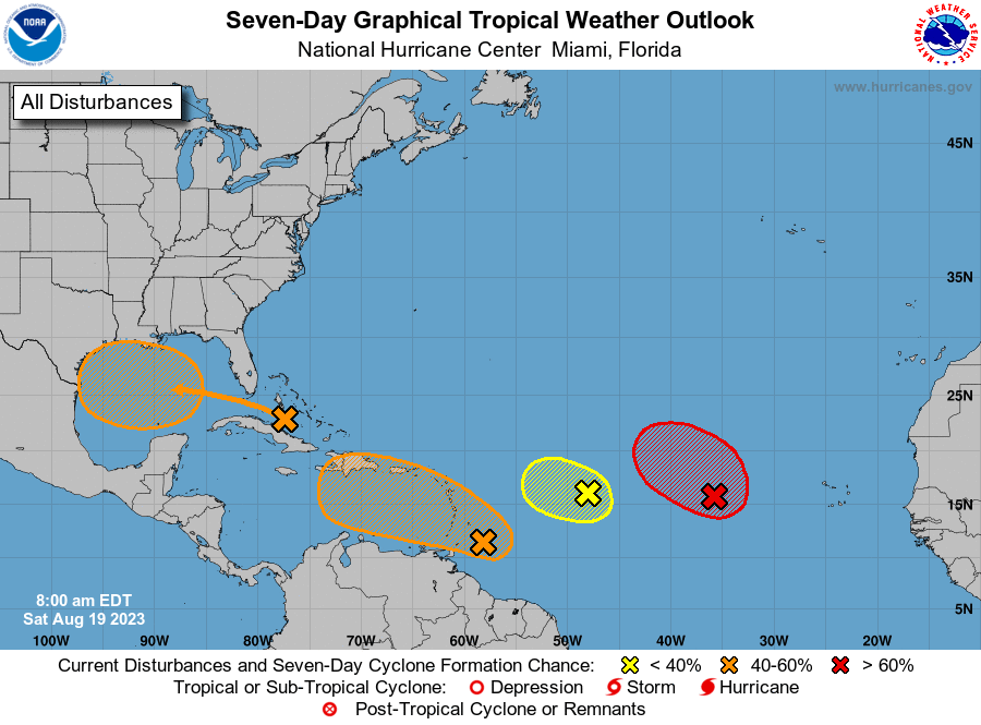
1. Eastern Tropical Atlantic (AL98):
Shower and thunderstorm activity continues in association with a
broad area of low pressure located several hundred miles west of the
Cabo Verde Islands. Environmental conditions appear generally
favorable for further development of this system, and a short-lived
tropical depression is likely to form this weekend while it moves
west-northwestward or northwestward at about 10 mph across the
eastern tropical Atlantic. By early next week, upper-level winds
over the system are forecast to increase, and further development is
not expected.
* Formation chance through 48 hours...high...70 percent.
* Formation chance through 7 days...high...70 percent.
2. Central Tropical Atlantic (AL99):
An area of low pressure located roughly halfway between the Cabo
Verde Islands and the Lesser Antilles is producing disorganized
showers and thunderstorms to the east of its center. Environmental
conditions are forecast to become increasingly unfavorable for
further development of this system during the next day or two while
it moves west-northwestward at 10 to 15 mph across the central
tropical Atlantic.
* Formation chance through 48 hours...low...30 percent.
* Formation chance through 7 days...low...30 percent.
3. East-Southeast of the Lesser Antilles (AL90):
A tropical wave located just east of the Windward Islands is
producing disorganized showers and thunderstorms. Some gradual
development of this system is possible and a tropical depression
could form during the early and middle parts of next week while it
moves westward to west-northwestward at 10 to 15 mph, across the
Lesser Antilles and over the eastern and central Caribbean Sea.
* Formation chance through 48 hours...low...20 percent.
* Formation chance through 7 days...medium...40 percent.
4. Western Gulf of Mexico:
An area of disturbed weather located near the northwestern and
central Bahamas is expected to move into the Gulf of Mexico by early
next week, where a broad area of low pressure is expected to form.
Some slow development of this system is possible thereafter, and a
tropical depression could form as it moves westward and approaches
the western Gulf of Mexico coastline by the middle of next week.
* Formation chance through 48 hours...low...near 0 percent.
* Formation chance through 7 days...medium...50 percent.
Forecaster Bucci