ZCZC MIATWOAT ALL
TTAA00 KNHC DDHHMM
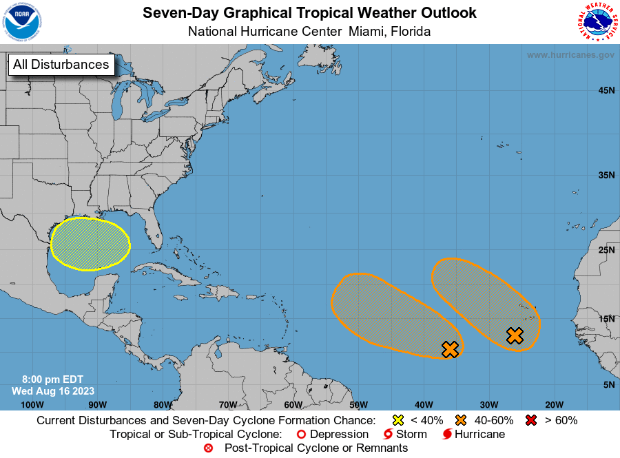
Tropical Weather Outlook
NWS National Hurricane Center Miami FL
800 PM EDT Wed Aug 16 2023
For the North Atlantic...Caribbean Sea and the Gulf of Mexico:
1. Central Tropical Atlantic:
Disorganized showers and thunderstorms continue in association with
an elongated trough of low pressure centered about 750 miles
west-southwest of the Cabo Verde Islands. Environmental conditions
appear conducive for gradual development of this system, and a
tropical depression could form during the next several days while it
moves westward or west-northwestward at about 10 mph across the
central tropical Atlantic.
* Formation chance through 48 hours...low...30 percent.
* Formation chance through 7 days...medium...50 percent.
2. Eastern Tropical Atlantic:
A broad area of low pressure is forming just to the south-southwest
of the Cabo Verde Islands, in association with a tropical wave
producing a large area of disorganized showers and thunderstorms.
Further development of this low is possible, and a tropical
depression could form over the weekend before environmental
conditions become unfavorable by early next week as the system moves
west-northwestward or northwestward at around 10-15 mph.
* Formation chance through 48 hours...low...30 percent.
* Formation chance through 7 days...medium...50 percent.
3. Western Gulf of Mexico:
A broad area of low pressure could form in the central or western
Gulf of Mexico by the beginning of next week. Some slow development
of this system is possible thereafter as it moves westward and
approaches the western Gulf of Mexico coastline by the middle of
next week.
* Formation chance through 48 hours...low...near 0 percent.
* Formation chance through 7 days...low...20 percent.
Forecaster Papin