ZCZC MIATWOAT ALL
TTAA00 KNHC DDHHMM
Tropical Weather Outlook
NWS National Hurricane Center Miami FL
200 AM EDT Mon Jul 31 2023
For the North Atlantic...Caribbean Sea and the Gulf of Mexico:
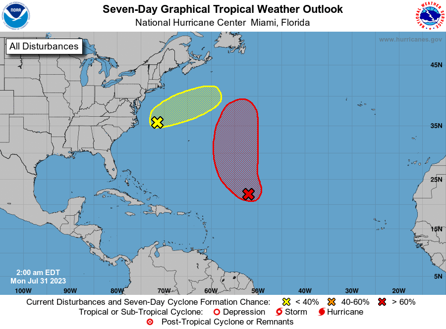
1. Central Tropical Atlantic (AL96):
Shower and thunderstorm activity continues in association with an
area of low pressure located about 750 miles east-northeast of the
northern Leeward Islands. Environmental conditions are forecast to
be marginally favorable for development over the next few days, and
a tropical depression is likely to form during the next day or so.
The system is expected to move northwestward at about 15 mph today,
and then turn northward over the central subtropical Atlantic by
late tonight or Tuesday. Additional information on this system,
including gale warnings, can be found in High Seas Forecasts issued
by the National Weather Service.
* Formation chance through 48 hours...high...70 percent.
* Formation chance through 7 days...high...80 percent.
2. Off the U.S. Mid-Atlantic Coast (AL97):
Shower and thunderstorm activity has recently shown little change
in organization in association with an area of low pressure located
offshore of the U.S. Mid-Atlantic coast. Environmental conditions
appear generally favorable for some development, and a short-lived
tropical cyclone could develop before the system merges with a
frontal boundary within the next day or so. Regardless of whether
the system becomes tropical or not, gale-force winds are
expected starting later today, and additional information on this
system can be found in High Seas Forecasts issued by the National
Weather Service.
* Formation chance through 48 hours...low...30 percent.
* Formation chance through 7 days...low...30 percent.
For more information about marine hazards associated with AL96
and AL97, please see High Seas Forecasts issued by the National
Weather Service found under AWIPS header NFDHSFAT1, WMO header
FZNT01 KWBC, and online at
ocean.weather.gov/shtml/NFDHSFAT1.php
Forecaster Pasch