ZCZC MIATWOAT ALL
TTAA00 KNHC DDHHMM
Tropical Weather Outlook
NWS National Hurricane Center Miami FL
200 PM EDT Fri Jul 28 2023
For the North Atlantic...Caribbean Sea and the Gulf of Mexico:
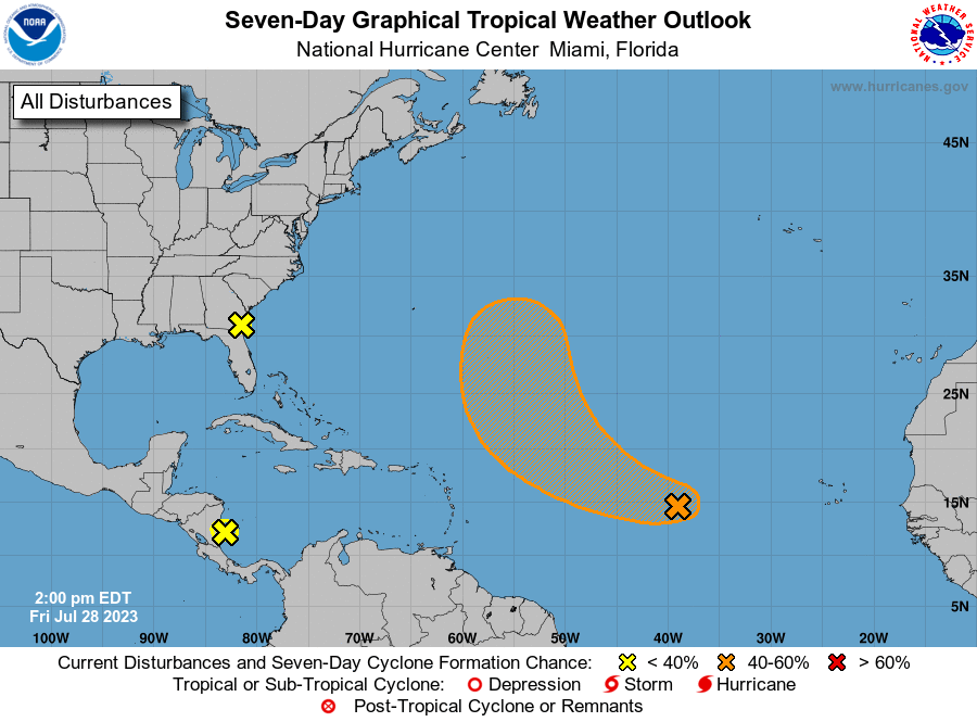
1. Central Tropical Atlantic:
A tropical wave located about midway between the Cabo Verde Islands
and the Lesser Antilles continues to produce disorganized cloudiness
and showers. Environmental conditions are expected to be favorable
for gradual development of this system during the next few days, and
a tropical depression could form early next week while the
disturbance moves west-northwestward to northwestward at about
15 mph.
* Formation chance through 48 hours...low...20 percent.
* Formation chance through 7 days...medium...60 percent.
2. Southwestern Atlantic:
Satellite, surface, and radar data show that a weak area of low
pressure has moved just inland near the Florida/Georgia border.
This system is forecast to move north-northwestward over inland
portions of eastern Georgia through tonight, and no additional
development is expected. The disturbance could bring locally heavy
rainfall to portions of northeastern Florida, eastern Georgia, and
eastern South Carolina during the next day or so.
* Formation chance through 48 hours...low...near 0 percent.
* Formation chance through 7 days...low...near 0 percent.
3. Southwestern Caribbean Sea:
A large area of disorganized showers and thunderstorms over the
southwestern Caribbean Sea and portions of Central America are
associated with a tropical wave and broad area of low pressure
located near the eastern coast of Central America. This system is
forecast to move westward over Central America later today or
tonight, and significant development is not anticipated. Regardless
of development, locally heavy rainfall is possible over portions of
Nicaragua and Honduras during the next day or so.
* Formation chance through 48 hours...low...10 percent.
* Formation chance through 7 days...low...10 percent.
Forecaster Brown