


NHC Graphical Outlook Archive
« Earliest Available ‹ Earlier Later › Latest Available »
Place your mouse cursor over areas of interest for more information
| GIS data: .shp |
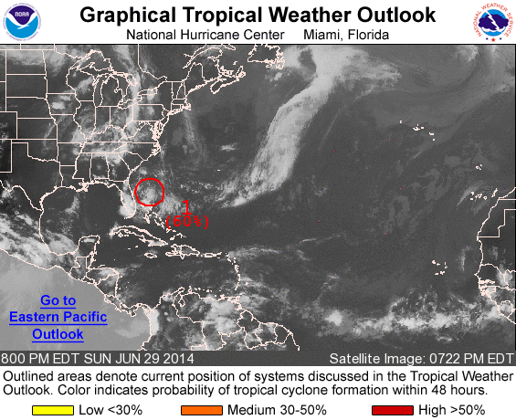
ZCZC MIATWOAT ALL
TTAA00 KNHC DDHHMM

TROPICAL WEATHER OUTLOOK
NWS NATIONAL HURRICANE CENTER MIAMI FL
800 PM EDT SUN JUN 29 2014

For the North Atlantic...Caribbean Sea and the Gulf of Mexico:

1. Showers and thunderstorms associated with a low pressure area
located about 230 miles east of St. Augustine, Florida, remain
limited.  Environmental conditions are forecast to become more
conducive for development during the next few days and a tropical
depression is likely to form by mid-week while the system moves
slowly southward to southwestward off the east-central coast of
Florida.  An Air Force Reserve reconnaissance aircraft is
scheduled to investigate the disturbance on Monday, if necessary.
* Formation chance through 48 hours...high...60 percent.
* Formation chance through 5 days...high...80 percent.

Forecaster Brown
List of all Atlantic Outlooks
List of all East Pacific Outlooks