Definition:
The cone represents the probable track of the center of a tropical cyclone, and is formed by enclosing the area swept out by a set of circles (not shown) along the forecast track (at 12, 24, 36 hours, etc). The size of each circle is set so that two-thirds of historical official forecast errors over a 5-year sample fall within the circle. The circle radii defining the cones in 2024 for the Atlantic, Eastern North Pacific, and Central North Pacific basins are given in the table below.
One can also examine historical tracks to determine how often the entire 5-day path of a cyclone remains completely within the area of the cone. This is a different perspective that ignores most timing errors. For example, a storm moving very slowly but in the expected direction would still be within the area of the cone, even though the track forecast error could be very large. Based on forecasts over the previous 5 years, the entire track of the tropical cyclone can be expected to remain within the cone roughly 60-70% of the time.
Radii of NHC and CPHC forecast cone circles for 2024, based on error statistics from 2019-2023:
Forecast Period |
2/3 Probability Circle, |
2/3 Probability Circle, |
2/3 Probability Circle, |
| 12 | 26 | 26 | 34 |
| 24 | 41 | 39 | 49 |
| 36 | 55 | 53 | 66 |
| 48 | 70 | 65 | 81 |
| 60 | 88 | 76 | 95 |
| 72 | 102 | 92 | 120 |
| 96 | 151 | 119 | 137 |
| 120 | 220 | 152 | 156 |
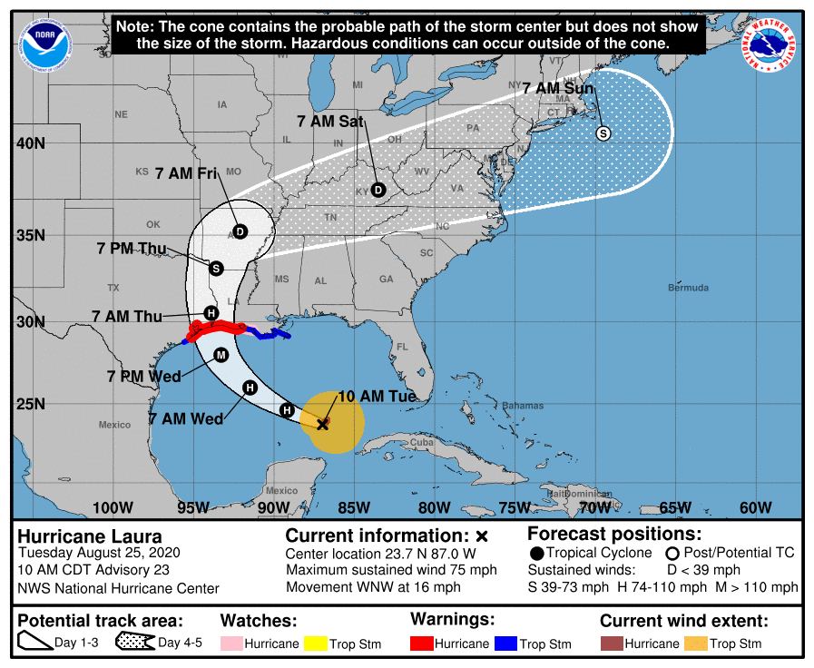
Example Graphic of 5-Day Track Forecast Cone:
Alternate Formats
About Alternates -
E-Mail Advisories -
RSS Feeds
Cyclone Forecasts
Latest Advisory -
Past Advisories -
About Advisories
Marine Forecasts
Latest Products -
About Marine Products
Tools & Data
Satellite Imagery -
US Weather Radar -
Aircraft Recon -
Local Data Archive -
Forecast Verification -
Deadliest/Costliest/Most Intense
Learn About Hurricanes
Storm Names
Wind Scale -
Prepare -
Climatology -
NHC Glossary -
NHC Acronyms -
Frequently Asked Questions -
AOML Hurricane-Research Division
About Us
About NHC -
Mission/Vision -
Other NCEP Centers -
NHC Staff -
Visitor Information -
NHC Library
NOAA/
National Weather Service
National Centers for Environmental Prediction
National Hurricane Center
11691 SW 17th Street
Miami, Florida, 33165-2149 USA
nhcwebmaster@noaa.gov
Disclaimer
Privacy Policy
Credits
About Us
Glossary
Career Opportunities
Page last modified: Thursday, 04-Apr-2024 19:21:13 UTC