


NHC Offshore Waters Forecasts
Hover to view popup zone forecast; click a zone to view related text forecast below. Show All Text Below
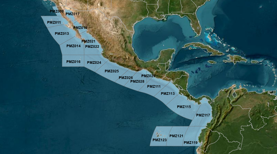
East Pacific within 250 nm of Mexico (OFFPZ7)
000
FZPN27 KNHC 300309
OFFPZ7

Offshore Waters Forecast
National Weather Service National Hurricane Center Miami, FL
809 PM PDT Mon Apr 29 2024

Offshore Waters Forecast for the E Pacific within 250 nm of
Mexico

Seas given as significant wave height, which is the average
height of the highest 1/3 of the waves. Individual waves may be
more than twice the significant wave height.
Synopsis for the E Pacific within 250 nm of Mexico
PMZ001-301515-
Synopsis for the E Pacific within 250 nm of Mexico
809 PM PDT Mon Apr 29 2024

.SYNOPSIS...Moderate to fresh NW winds along with large NW swell
will persist off Baja California Norte mainly west of Isla
Guadalupe through late Thu, with gentle to moderate winds
elsewhere off Baja. Moderate to fresh SW winds will pulse across
the northern Gulf of California Tue night, following a
dissipating cold front moving through the region. Elsewhere,
mostly gentle to moderate winds will persist across the Mexican
offshore waters, along with moderate combined seas primarily in
NW swell over open waters. Looking ahead, winds and seas will
diminish off Baja California Fri and Sat as the high pressure NW
of the area weakens.
PMZ009 Zone Forecast
PMZ009-301515-
Mexico Border S to 30N within 60 nm of shore-
809 PM PDT Mon Apr 29 2024

.OVERNIGHT...N of 31N, NW winds 10 kt in the evening, becoming
variable winds less than 5 kt. S of 31N, NW winds 10 kt. Seas
8 to 9 ft. Period 10 seconds.
.TUE...Variable winds less than 5 kt. Seas 8 ft. Period
11 seconds.
.TUE NIGHT...N of 31N, variable winds less than 5 kt, becoming S
to SW 10 kt late. S of 31N, variable winds less than
5 kt. Seas 8 ft. Period 11 seconds.
.WED...SW to W winds 10 kt. Seas 9 ft. Period 11 seconds.
.WED NIGHT...W winds 10 kt. Seas 4 to 6 ft. Period 11 seconds.
.THU...Variable winds less than 5 kt. Seas 3 to 5 ft. Period
11 seconds.
.THU NIGHT...Variable winds less than 5 kt. Seas 3 to 5 ft.
Period 11 seconds.
.FRI...Variable winds less than 5 kt. Seas 3 to 5 ft. Period
10 seconds.
.FRI NIGHT...W to NW winds 10 kt. Seas 3 to 5 ft. Period
10 seconds.
.SAT...W to NW winds 10 kt. Seas 3 to 5 ft. Period 14 seconds.
.SAT NIGHT...NW winds 10 kt. Seas 3 to 4 ft. Period 14 seconds.
Forecaster Stripling
PMZ011 Zone Forecast
PMZ011-301515-
30N to Punta Eugenia within 250 nm of shore-
809 PM PDT Mon Apr 29 2024

.OVERNIGHT...Within 60 nm of the coast, NW winds 10 to 15 kt,
Seas 8 to 9 ft. Elsewhere, NW winds 15 to 20 kt, Seas 11 to
12 ft. Period 10 seconds.
.TUE...Within 60 nm of the coast, W to NW winds 10 kt, Seas
8 ft. Elsewhere, NW winds 15 to 20 kt, Seas 12 to 13 ft. Period
11 seconds.
.TUE NIGHT...Within 60 nm of the coast, W to NW winds 10 kt,
Seas 8 ft. Elsewhere, NW winds 15 to 20 kt, Seas 13 ft. Period
11 seconds.
.WED...Within 60 nm of the coast, W to NW winds 10 kt, Seas
8 ft. Elsewhere, NW winds 15 to 20 kt, Seas 13 ft. Period
11 seconds.
.WED NIGHT...NW winds 10 kt within 60 nm of the coast, and NW
15 to 20 kt Elsewhere. Seas 5 to 7 ft. Period 11 seconds.
.THU...NW winds 10 to 15 kt. Seas 5 to 7 ft. Period 11 seconds.
.THU NIGHT...NW winds 10 to 15 kt. Seas 4 to 6 ft. Period
11 seconds.
.FRI...NW winds 10 to 15 kt. Seas 4 to 6 ft. Period 11 seconds.
.FRI NIGHT...NW winds 10 to 15 kt. Seas 4 to 6 ft. Period
10 seconds.
.SAT...NW winds 10 kt. Seas 3 to 5 ft. Period 9 seconds.
.SAT NIGHT...NW winds 10 kt. Seas 3 to 4 ft. Period 13 seconds.
Forecaster Stripling
PMZ013 Zone Forecast
PMZ013-301515-
Punta Eugenia to Cabo San Lazaro within 250 nm offshore-
809 PM PDT Mon Apr 29 2024

.OVERNIGHT...NW winds 10 to 15 kt. Seas 7 ft Within 60 nm of
shore, and 9 to 10 ft Elsewhere. Period 14 seconds.
.TUE...NW winds 10 to 15 kt. Seas 9 ft. Period 13 seconds.
.TUE NIGHT...NW winds 10 to 15 kt. Seas 7 ft Within 60 nm of
shore, and 9 to 10 ft Elsewhere. Period 12 seconds.
.WED...NW winds 10 kt. Seas 7 ft Within 60 nm of shore, and
10 ft Elsewhere. Period 11 seconds.
.WED NIGHT...NW winds 10 to 15 kt. Seas 4 to 6 ft. Period
11 seconds.
.THU...NW winds 10 kt. Seas 4 to 6 ft. Period 11 seconds.
.THU NIGHT...NW winds 10 to 15 kt. Seas 4 to 6 ft. Period
11 seconds.
.FRI...NW winds 10 kt. Seas 4 to 6 ft. Period 11 seconds.
.FRI NIGHT...NW winds 10 to 15 kt. Seas 3 to 5 ft. Period
14 seconds.
.SAT...NW to N winds 10 to 15 kt. Seas 3 to 5 ft. Period
14 seconds.
.SAT NIGHT...NW to N winds 10 to 15 kt. Seas 3 to 5 ft. Period
14 seconds.
Forecaster Stripling
PMZ014 Zone Forecast
PMZ014-301515-
Cabo San Lazaro to Cabo San Lucas within 350 nm offshore N of
20N-
809 PM PDT Mon Apr 29 2024

.OVERNIGHT...NW to N winds 10 kt. Seas 6 to 7 ft. Period
14 seconds.
.TUE...NW to N winds 10 kt. Seas 6 ft. Period 14 seconds.
.TUE NIGHT...NW to N winds 10 to 15 kt. Seas 6 ft. Period
13 seconds.
.WED...NW to N winds 10 to 15 kt. Seas 7 ft. Period 12 seconds.
.WED NIGHT...NW winds 10 to 15 kt. Seas 3 to 5 ft. Period
12 seconds.
.THU...NW to N winds 10 kt. Seas 3 to 5 ft. Period 13 seconds.
.THU NIGHT...NW winds 10 to 15 kt. Seas 3 to 5 ft. Period
14 seconds.
.FRI...NW to N winds 10 to 15 kt. Seas 3 to 5 ft. Period
14 seconds.
.FRI NIGHT...NW to N winds 10 to 15 kt. Seas 3 to 5 ft. Period
14 seconds.
.SAT...NW to N winds 10 to 15 kt. Seas 3 to 5 ft. Period
13 seconds.
.SAT NIGHT...NW to N winds 10 to 15 kt. Seas 3 to 5 ft. Period
13 seconds.
Forecaster Stripling
PMZ016 Zone Forecast
PMZ016-301515-
From 17N to 20N Between 110W and 115W including the
Revillagigedo Islands-
809 PM PDT Mon Apr 29 2024

.OVERNIGHT...N winds 10 kt in the evening, becoming variable
winds less than 5 kt. Seas 6 ft. Period 14 seconds.
.TUE...NW to N winds 10 kt. Seas 6 ft. Period 14 seconds.
.TUE NIGHT...N winds 10 kt. Seas 6 ft. Period 13 seconds.
.WED...NW to N winds 10 kt. Seas 6 ft. Period 13 seconds.
.WED NIGHT...NW to N winds 10 kt. Seas 5 to 6 ft. Period
12 seconds.
.THU...N winds 10 kt. Seas 5 to 7 ft. Period 12 seconds.
.THU NIGHT...NW to N winds 10 kt. Seas 5 to 7 ft. Period
11 seconds.
.FRI...N winds 10 kt. Seas 5 to 7 ft. Period 12 seconds.
.FRI NIGHT...NW to N winds 10 kt. Seas 5 to 6 ft. Period
12 seconds.
.SAT...N winds 10 kt. Seas 5 to 6 ft. Period 12 seconds.
.SAT NIGHT...N winds 10 kt. Seas 5 to 6 ft. Period 11 seconds.
Forecaster Stripling
PMZ017 Zone Forecast
PMZ017-301515-
Northern Gulf of California-
809 PM PDT Mon Apr 29 2024

.OVERNIGHT...S winds 10 to 15 kt. Seas 2 ft or less. Period
3 seconds.
.TUE...SE to S winds 10 kt. Seas 2 ft or less, becoming 3 ft in
the afternoon. Period 4 seconds.
.TUE NIGHT...S winds 10 to 15 kt, becoming S to SW 15 to 20 kt
late. Seas 4 to 5 ft. Period 4 seconds.
.WED...SE to S winds 10 to 15 kt. Seas 4 to 5 ft. Period
5 seconds.
.WED NIGHT...S winds 10 kt. Seas 2 ft or less. Period 4 seconds.
.THU...SE to S winds 10 kt. Seas 2 ft or less. Period 4 seconds.
.THU NIGHT...S winds 10 kt. Seas 2 ft or less. Period 4 seconds.
.FRI...SE to S winds 10 kt. Seas 2 ft or less. Period 4 seconds.
.FRI NIGHT...S winds 10 to 15 kt. Seas 2 ft or less. Period
4 seconds.
.SAT...S winds 10 kt. Seas 2 ft or less. Period 4 seconds.
.SAT NIGHT...S winds 10 to 15 kt. Seas 2 ft or less. Period
5 seconds.
Forecaster Stripling
PMZ019 Zone Forecast
PMZ019-301515-
Central Gulf of California-
809 PM PDT Mon Apr 29 2024

.OVERNIGHT...S to SW winds 10 kt. Seas 2 ft or less. Period
15 seconds.
.TUE...SE to S winds 10 kt. Seas 2 ft or less, becoming 3 ft in
the afternoon. Period 14 seconds.
.TUE NIGHT...S to SW winds 10 to 15 kt. Seas 4 ft. Period
14 seconds.
.WED...S winds 10 kt. Seas 3 to 4 ft. Period 4 seconds.
.WED NIGHT...S to SW winds 10 kt. Seas 2 ft or less. Period
18 seconds.
.THU...SE to S winds 10 kt. Seas 2 ft or less. Period
18 seconds.
.THU NIGHT...S winds 10 kt. Seas 2 ft or less. Period
17 seconds.
.FRI...Variable winds less than 5 kt. Seas 2 ft or less. Period
16 seconds.
.FRI NIGHT...S to SW winds 10 kt. Seas 2 ft or less. Period
15 seconds.
.SAT...S winds 10 kt. Seas 2 ft or less. Period 14 seconds.
.SAT NIGHT...SW winds 10 kt. Seas 2 ft or less. Period
13 seconds.
Forecaster Stripling
PMZ021 Zone Forecast
PMZ021-301515-
Southern Gulf of California-
809 PM PDT Mon Apr 29 2024

.OVERNIGHT...SW to W winds 10 kt. Seas 3 ft. Period 15 seconds.
.TUE...S winds 10 kt. Seas 3 ft. Period 14 seconds.
.TUE NIGHT...S to SW winds 10 to 15 kt. Seas 4 ft. Period
14 seconds.
.WED...S winds 10 kt. Seas 4 to 5 ft. Period 18 seconds.
.WED NIGHT...S to SW winds 10 to 15 kt. Seas 2 ft or less.
Period 18 seconds.
.THU...S winds 10 kt. Seas 2 ft or less. Period 17 seconds.
.THU NIGHT...S to SW winds 10 kt. Seas 2 ft or less. Period
16 seconds.
.FRI...W to NW winds 10 kt. Seas 2 ft or less. Period
15 seconds.
.FRI NIGHT...SW to W winds 10 kt. Seas 2 ft or less. Period
14 seconds.
.SAT...W winds 10 kt. Seas 2 ft or less. Period 14 seconds.
.SAT NIGHT...SW to W winds 10 kt. Seas 2 ft or less. Period
14 seconds.
Forecaster Stripling
PMZ022 Zone Forecast
PMZ022-301515-
N of 20N E of 110W to the Entrance of the Gulf of California-
809 PM PDT Mon Apr 29 2024

.OVERNIGHT...NW winds 10 kt. Seas 5 ft. Period 14 seconds.
.TUE...W to NW winds 10 kt. Seas 5 ft. Period 14 seconds.
.TUE NIGHT...W to NW winds 10 to 15 kt. Seas 5 to 6 ft. Period
14 seconds.
.WED...W to NW winds 10 kt. Seas 6 ft. Period 17 seconds.
.WED NIGHT...W winds 10 to 15 kt. Seas 3 to 4 ft. Period
17 seconds.
.THU...W to NW winds 10 to 15 kt. Seas 3 to 5 ft. Period
16 seconds.
.THU NIGHT...W to NW winds 10 to 15 kt. Seas 3 to 4 ft. Period
16 seconds.
.FRI...NW winds 10 to 15 kt. Seas 3 to 4 ft. Period 15 seconds.
.FRI NIGHT...NW winds 10 kt. Seas 3 to 4 ft. Period 14 seconds.
.SAT...NW winds 10 kt. Seas 3 to 4 ft. Period 14 seconds.
.SAT NIGHT...NW winds 10 kt. Seas 3 ft. Period 14 seconds.
Forecaster Stripling
PMZ024 Zone Forecast
PMZ024-301515-
Colima and Jalisco within 300 nm offshore S of 20N and E of
110W-
809 PM PDT Mon Apr 29 2024

.OVERNIGHT...NW to N winds 10 kt. Seas 5 ft. Period 14 seconds.
.TUE...NW to N winds 10 kt. Seas 5 ft. Period 14 seconds.
.TUE NIGHT...NW winds 10 to 15 kt. Seas 5 ft. Period 14 seconds.
.WED...NW to N winds 10 kt. Seas 6 ft. Period 16 seconds.
.WED NIGHT...NW winds 10 kt. Seas 3 to 4 ft. Period 16 seconds.
.THU...NW to N winds 10 kt. Seas 3 to 4 ft. Period 15 seconds.
.THU NIGHT...NW winds 10 to 15 kt. Seas 3 to 5 ft. Period
15 seconds.
.FRI...NW to N winds 10 to 15 kt. Seas 3 to 5 ft. Period
14 seconds.
.FRI NIGHT...NW winds 10 to 15 kt. Seas 3 to 5 ft. Period
14 seconds.
.SAT...NW to N winds 10 kt. Seas 3 to 5 ft. Period 14 seconds.
.SAT NIGHT...NW to N winds 10 kt. Seas 3 to 5 ft. Period
14 seconds.
Forecaster Stripling
PMZ025 Zone Forecast
PMZ025-301515-
Michoacan and Guerrero within 250 nm offshore-
809 PM PDT Mon Apr 29 2024

.OVERNIGHT...Within 60 nm of shore, W to NW winds 10 kt in the
evening, becoming variable winds less than 5 kt. Elsewhere,
variable winds less than 5 kt. Seas 5 ft. Period 14 seconds.
.TUE...Within 60 nm of shore, variable winds less than 5 kt,
becoming W 10 kt in the afternoon. Elsewhere, N winds 10 kt in
the morning, becoming variable winds less than 5 kt. Seas 5 ft.
Period 14 seconds.
.TUE NIGHT...NW winds 10 kt. Seas 5 ft. Period 17 seconds.
.WED...NW winds 10 kt. Seas 5 ft. Period 17 seconds.
.WED NIGHT...NW winds 10 kt. Seas 3 ft. Period 16 seconds.
.THU...NW winds 10 kt. Seas 3 to 4 ft. Period 15 seconds.
.THU NIGHT...NW winds 10 to 15 kt. Seas 3 to 5 ft. Period
15 seconds.
.FRI...NW winds 10 kt. Seas 3 to 5 ft. Period 14 seconds.
.FRI NIGHT...NW winds 10 kt. Seas 3 to 5 ft. Period 14 seconds.
.SAT...NW winds 10 kt. Seas 3 to 5 ft. Period 15 seconds.
.SAT NIGHT...NW winds 10 kt. Seas 3 to 4 ft. Period 15 seconds.
Forecaster Stripling
PMZ026 Zone Forecast
PMZ026-301515-
Oaxaca W of Puerto Angel within 250 nm offshore-
809 PM PDT Mon Apr 29 2024

.OVERNIGHT...Variable winds less than 5 kt. Seas 5 ft. Period
14 seconds.
.TUE...Variable winds less than 5 kt. Seas 5 ft. Period
15 seconds.
.TUE NIGHT...Variable winds less than 5 kt. Seas 5 ft. Period
17 seconds.
.WED...NW to N winds 10 kt. Seas 5 ft. Period 16 seconds.
.WED NIGHT...NW winds 10 kt N of 14N, and variable less than
5 kt S of 14N. Seas 3 ft. Period 16 seconds.
.THU...NW to N winds 10 kt. Seas 3 ft. Period 15 seconds.
.THU NIGHT...NW winds 10 kt. Seas 3 to 5 ft. Period 14 seconds.
.FRI...NW winds 10 kt. Seas 3 to 5 ft. Period 14 seconds.
.FRI NIGHT...W to NW winds 10 kt N of 14N, and variable less
than 5 kt S of 14N. Seas 3 to 5 ft. Period 15 seconds.
.SAT...NW winds 10 kt. Seas 3 to 5 ft. Period 15 seconds.
.SAT NIGHT...W to NW winds 10 kt N of 14N, and variable less
than 5 kt S of 14N. Seas 3 to 5 ft. Period 15 seconds.
Forecaster Stripling
PMZ028 Zone Forecast
PMZ028-301515-
Oaxaca E of Puerto Angel within 300 nm offshore including the
Gulf of Tehuantepec-
809 PM PDT Mon Apr 29 2024

.OVERNIGHT...NE to E winds 10 kt. Seas 5 ft. Period 14 seconds.
.TUE...NE winds 10 kt. Seas 5 ft. Period 16 seconds.
.TUE NIGHT...N of 14N, SW winds 10 kt in the evening, becoming
variable winds less than 5 kt. S of 14N, NE to E winds 10 kt.
Seas 5 ft. Period 17 seconds.
.WED...N of 14N, variable winds less than 5 kt, becoming SW
10 kt in the afternoon. S of 14N, NE to E winds 10 kt. Seas
5 ft. Period 17 seconds.
.WED NIGHT...SW to W winds 10 kt N of 14N, and variable less
than 5 kt S of 14N. Seas 3 ft. Period 16 seconds.
.THU...SW to W winds 10 kt N of 14N, and variable less than 5 kt
S of 14N. Seas 3 ft. Period 15 seconds.
.THU NIGHT...SW to W winds 10 kt N of 14N, and variable less
than 5 kt S of 14N. Seas 3 to 4 ft. Period 14 seconds.
.FRI...SW to W winds 10 kt N of 14N, and variable less than 5 kt
S of 14N. Seas 3 to 4 ft. Period 15 seconds.
.FRI NIGHT...SW to W winds 10 kt N of 14N, and variable less
than 5 kt S of 14N. Seas 3 to 4 ft. Period 16 seconds.
.SAT...W winds 10 kt N of 14N, and variable less than 5 kt S of
14N. Seas 3 to 4 ft. Period 16 seconds.
.SAT NIGHT...W winds 10 kt N of 14N, and variable less than 5 kt
S of 14N. Seas 3 to 5 ft. Period 15 seconds.
Forecaster Stripling
PMZ029 Zone Forecast
PMZ029-301515-
Offshore Chiapas E of 94W-
809 PM PDT Mon Apr 29 2024

.OVERNIGHT...Variable winds less than 5 kt. Seas 5 ft. Period
14 seconds.
.TUE...E of 93W, variable winds less than 5 kt, becoming SW
10 kt in the afternoon. W of 93W, N to NE winds 10 kt, shifting
to S to SW in the afternoon. Seas 5 ft. Period 14 seconds.
.TUE NIGHT...E of 93W, variable winds less than 5 kt in the
evening. Variable winds less than 5 kt late. W of 93W,
E to SE winds 10 kt in the evening. Seas 5 ft. Period
17 seconds.
.WED...Variable winds less than 5 kt, becoming SW 10 kt in the
afternoon. Seas 5 ft. Period 17 seconds.
.WED NIGHT...Variable winds less than 5 kt. Seas 3 ft. Period
16 seconds.
.THU...W winds 10 kt. Seas 3 ft. Period 15 seconds.
.THU NIGHT...Variable winds less than 5 kt. Seas 3 to 5 ft.
Period 14 seconds.
.FRI...W winds 10 kt. Seas 3 to 5 ft. Period 13 seconds.
.FRI NIGHT...Variable winds less than 5 kt. Seas 3 to 4 ft.
Period 16 seconds.
.SAT...W to NW winds 10 kt. Seas 3 to 4 ft. Period 16 seconds.
.SAT NIGHT...Variable winds less than 5 kt. Seas 3 to 4 ft.
Period 15 seconds.
Forecaster Stripling
East Pacific offshore of Central America, Colombia, & Ecuador (OFFPZ8)
635
FZPN28 KNHC 300311
OFFPZ8

Offshore Waters Forecast
NWS National Hurricane Center Miami, FL
811 PM PDT Mon Apr 29 2024

Offshore Waters Forecast for the E Pacific within 250 nm of
Central America, Colombia, and within 750 nm of Ecuador

Seas given as significant wave height, which is the average
height of the highest 1/3 of the waves. Individual waves may be
more than twice the significant wave height.
Synopsis for the E Pacific within 250 nm of Central America, Colombia, and within 750 nm of Ecuador
PMZ101-301515-
Synopsis for the E Pacific within 250 nm of Central America,
Colombia, and within 750 nm of Ecuador
811 PM PDT Mon Apr 29 2024

.SYNOPSIS...A weaker than normal pressure pattern is expected to
persist across the southwest Caribbean through late week,
leading to gentle to moderate winds across the area Pacific
waters. Moderate seas in S to SW swell will subside through
tonight before new S swell raises seas slightly across the
regional waters Tue into Wed. Looking ahead, reinforcing S swell
is expected across the region Thu through Sat.
PMZ111 Zone Forecast
PMZ111-301515-
Guatemala and El Salvador to 250 nm offshore-
811 PM PDT Mon Apr 29 2024

.TONIGHT...SE winds 10 kt in the evening, becoming variable
winds less than 5 kt. Seas 3 to 5 ft in S to SW swell. Period
14 seconds.
.TUE...E to SE winds 10 kt. Seas 3 to 5 ft. Period 17 seconds.
Scattered showers through the day.
.TUE NIGHT...SE to S winds 10 kt in the evening, becoming
variable winds less than 5 kt. Seas 3 to 5 ft in S to SW swell.
Period 17 seconds.
.WED...Variable winds less than 5 kt, becoming S 10 kt in the
afternoon. Seas 3 to 5 ft. Period 16 seconds.
.WED NIGHT...SW winds 10 kt. Seas 3 to 5 ft. Period 14 seconds.
.THU...Variable winds less than 5 kt. Seas 3 to 5 ft in S swell.
Period 14 seconds.
.THU NIGHT...W winds 10 kt. Seas 3 to 5 ft. Period 13 seconds.
.FRI...Variable winds less than 5 kt. Seas 3 to 5 ft in S swell.
Period 13 seconds.
.FRI NIGHT...SW to W winds 10 kt. Seas 3 to 5 ft. Period
14 seconds.
.SAT...Variable winds less than 5 kt. Seas 3 to 5 ft in S swell.
Period 15 seconds.
.SAT NIGHT...Variable winds less than 5 kt. Seas 4 to 6 ft in S
swell. Period 14 seconds.
Forecaster Stripling
PMZ113 Zone Forecast
PMZ113-301515-
El Salvador to North Costa Rica including the Gulfs of Fonseca
and Papagayo-
811 PM PDT Mon Apr 29 2024

.TONIGHT...Offshore Gulf of Papagayo, S to SW winds 10 kt in the
evening, becoming variable winds less than 5 kt. Elsewhere, SW
winds 10 kt. Seas 3 to 5 ft in S to SW swell. Period 14 seconds.
Scattered showers through the night.
.TUE...Offshore Gulf of Papagayo, NE winds 10 kt in the morning,
becoming variable winds less than 5 kt. Elsewhere, E to SE winds
10 kt, shifting to S to SW in the afternoon. Seas 3 to 5 ft in
S to SW swell. Period 17 seconds. Scattered showers through the
day.
.TUE NIGHT...Offshore Gulf of Papagayo, SW to W winds 10 kt in
the evening, becoming variable winds less than 5 kt. Elsewhere,
SW to W winds 10 kt. Seas 3 to 5 ft in S to SW swell. Period
17 seconds.
.WED...Offshore Gulf of Papagayo, NE to E winds 10 to 15 kt in
the morning, becoming variable winds less than 5 kt. Elsewhere,
NW winds 10 kt. Seas 3 to 5 ft in S swell. Period 16 seconds.
.WED NIGHT...Variable winds less than 5 kt Offshore Gulf of
Papagayo, and SW to W 10 kt Elsewhere. Seas 3 to 5 ft in S
swell. Period 14 seconds.
.THU...E to SE winds 10 kt Offshore Gulf of Papagayo, and
variable less than 5 kt Elsewhere. Seas 3 to 5 ft in S swell.
Period 14 seconds.
.THU NIGHT...Variable winds less than 5 kt. Seas 3 to 5 ft in S
swell. Period 13 seconds.
.FRI...SE winds 10 kt Offshore Gulf of Papagayo, and variable
less than 5 kt Elsewhere. Seas 2 to 4 ft in S swell. Period
15 seconds.
.FRI NIGHT...W winds 10 kt. Seas 3 to 5 ft. Period 16 seconds.
.SAT...E winds 10 kt Offshore Gulf of Papagayo, and variable
less than 5 kt Elsewhere. Seas 3 to 5 ft. Period 15 seconds.
.SAT NIGHT...Variable winds less than 5 kt. Seas 3 to 5 ft in S
swell. Period 14 seconds.
Forecaster Stripling
PMZ115 Zone Forecast
PMZ115-301515-
North Costa Rica to West Panama to 250 nm offshore-
811 PM PDT Mon Apr 29 2024

.TONIGHT...Variable winds less than 5 kt Near the Azuero
Peninsula, and W 10 kt Elsewhere. Seas 3 to 5 ft in S to SW
swell. Period 17 seconds. Scattered showers through the night.
.TUE...Variable winds less than 5 kt. Seas 3 to 5 ft in S to SW
swell. Period 17 seconds. Scattered showers through the day.
.TUE NIGHT...Variable winds less than 5 kt. Seas 4 to 6 ft in S
swell. Period 17 seconds. Scattered showers through the night.
.WED...Variable winds less than 5 kt Near the Azuero Peninsula,
and SW to W 10 kt Elsewhere. Seas 4 to 6 ft in S swell. Period
16 seconds. Scattered showers and isolated tstms through the
day.
.WED NIGHT...Variable winds less than 5 kt Near the Azuero
Peninsula, and SW to W 10 kt Elsewhere. Seas 4 to 6 ft in S
swell. Period 14 seconds.
.THU...Variable winds less than 5 kt Near the Azuero Peninsula,
and SW to W 10 kt Elsewhere. Seas 4 to 6 ft in S swell. Period
13 seconds.
.THU NIGHT...Variable winds less than 5 kt Near the Azuero
Peninsula, and SW to W 10 kt Elsewhere. Seas 3 to 5 ft in S
swell. Period 15 seconds.
.FRI...Variable winds less than 5 kt Near the Azuero Peninsula,
and SW to W 10 kt Elsewhere. Seas 4 to 6 ft in S swell. Period
16 seconds.
.FRI NIGHT...SW to W winds 10 kt. Seas 4 to 6 ft in S swell.
Period 15 seconds.
.SAT...Variable winds less than 5 kt Near the Azuero Peninsula,
and SW to W 10 kt Elsewhere. Seas 4 to 6 ft in S swell. Period
14 seconds.
.SAT NIGHT...Variable winds less than 5 kt. Seas 4 to 6 ft in S
swell. Period 13 seconds.
Forecaster Stripling
PMZ117 Zone Forecast
PMZ117-301515-
East Panama and Colombia including the Gulf of Panama-
811 PM PDT Mon Apr 29 2024

.TONIGHT...Variable winds less than 5 kt. Seas 3 to 5 ft in S to
SW swell. Period 16 seconds. Scattered showers through the
night.
.TUE...Variable winds less than 5 kt. Seas 4 to 6 ft in S to SW
swell. Period 16 seconds.
.TUE NIGHT...Gulf of Panama, variable winds less than 5 kt.
Elsewhere, variable winds less than 5 kt, becoming SW 10 kt
late. Seas 4 to 6 ft in S to SW swell. Period
16 seconds. Scattered showers through the night.
.WED...Gulf of Panama, variable winds less than 5 kt, becoming
SW to W 10 kt in the afternoon. Elsewhere, SW winds 10 kt. Seas
5 to 7 ft in S to SW swell. Period 15 seconds. Scattered showers
through the day.
.WED NIGHT...Variable winds less than 5 kt Gulf of Panama, and
SW 10 kt Elsewhere. Seas 4 to 6 ft in S to SW swell. Period
13 seconds.
.THU...Variable winds less than 5 kt Gulf of Panama, and SW to W
10 kt Elsewhere. Seas 4 to 6 ft in S to SW swell. Period
13 seconds.
.THU NIGHT...Variable winds less than 5 kt Gulf of Panama, and
SW to W 10 kt Elsewhere. Seas 4 to 6 ft in S to SW swell. Period
14 seconds.
.FRI...Variable winds less than 5 kt Gulf of Panama, and SW to W
10 kt Elsewhere. Seas 4 to 6 ft in S to SW swell. Period
14 seconds.
.FRI NIGHT...Variable winds less than 5 kt Gulf of Panama, and
SW to W 10 kt Elsewhere. Seas 4 to 6 ft in S to SW swell. Period
15 seconds.
.SAT...Variable winds less than 5 kt Gulf of Panama, and SW to W
10 kt Elsewhere. Seas 4 to 6 ft in S to SW swell. Period
14 seconds.
.SAT NIGHT...Variable winds less than 5 kt. Seas 4 to 6 ft in S
to SW swell. Period 14 seconds.
Forecaster Stripling
PMZ119 Zone Forecast
PMZ119-301515-
Ecuador including the Gulf of Guayaquil to 250 nm offshore-
811 PM PDT Mon Apr 29 2024

.TONIGHT...Variable winds less than 5 kt. Seas 4 to 6 ft in S to
SW swell. Period 17 seconds.
.TUE...S to SW winds 10 kt. Seas 5 to 7 ft in S to SW swell.
Period 16 seconds.
.TUE NIGHT...S to SW winds 10 kt. Seas 5 to 7 ft in S to SW
swell. Period 15 seconds.
.WED...Gulf of Guayaquil, variable winds less than 5 kt,
becoming W 10 kt in the afternoon. Elsewhere, S to SW winds
10 kt. Seas 4 to 6 ft in S to SW swell. Period 14 seconds.
.WED NIGHT...S to SW winds 10 to 15 kt. Seas 4 to 6 ft. Period
13 seconds.
.THU...S to SW winds 10 kt. Seas 5 to 7 ft in S to SW swell.
Period 15 seconds.
.THU NIGHT...S to SW winds 10 kt. Seas 5 to 7 ft in S swell.
Period 15 seconds.
.FRI...S to SW winds 10 kt. Seas 5 to 7 ft in S swell. Period
15 seconds.
.FRI NIGHT...S to SW winds 10 kt. Seas 5 to 7 ft in S swell.
Period 14 seconds.
.SAT...S to SW winds 10 kt. Seas 5 to 7 ft in S swell. Period
13 seconds.
.SAT NIGHT...S to SW winds 10 kt. Seas 5 to 7 ft in S swell.
Period 13 seconds.
Forecaster Stripling
PMZ121 Zone Forecast
PMZ121-301515-
Ecuador between 250 and 500 nm offshore-
811 PM PDT Mon Apr 29 2024

.TONIGHT...Variable winds less than 5 kt. Seas 4 to 6 ft in S
swell. Period 17 seconds.
.TUE...Variable winds less than 5 kt, becoming SE to S 10 kt in
the afternoon. Seas 5 to 7 ft in S swell. Period 16 seconds.
.TUE NIGHT...SE to S winds 10 kt. Seas 5 to 7 ft in S swell.
Period 15 seconds.
.WED...SE to S winds 10 kt. Seas 5 to 7 ft in S swell. Period
14 seconds.
.WED NIGHT...SE to S winds 10 kt. Seas 4 to 6 ft in S swell.
Period 14 seconds.
.THU...SE winds 10 kt. Seas 5 to 7 ft in S swell. Period
15 seconds.
.THU NIGHT...SE to S winds 10 kt. Seas 5 to 7 ft in S swell.
Period 15 seconds.
.FRI...SE to S winds 10 kt. Seas 5 to 7 ft in S swell. Period
15 seconds.
.FRI NIGHT...SE to S winds 10 kt. Seas 5 to 7 ft in S swell.
Period 14 seconds.
.SAT...SE to S winds 10 kt. Seas 5 to 7 ft in S swell. Period
13 seconds.
.SAT NIGHT...SE to S winds 10 kt. Seas 5 to 7 ft in S swell.
Period 12 seconds.
Forecaster Stripling
PMZ123 Zone Forecast
PMZ123-301515-
Offshore Galapagos Islands-
811 PM PDT Mon Apr 29 2024

.TONIGHT...Variable winds less than 5 kt. Seas 4 to 6 ft in S
swell. Period 17 seconds.
.TUE...Variable winds less than 5 kt. Seas 4 to 6 ft in S swell.
Period 16 seconds.
.TUE NIGHT...Variable winds less than 5 kt. Seas 4 to 6 ft in S
swell. Period 15 seconds.
.WED...E to SE winds 10 kt. Seas 4 to 6 ft in S swell. Period
14 seconds.
.WED NIGHT...Variable winds less than 5 kt. Seas 4 to 6 ft in S
swell. Period 14 seconds.
.THU...E to SE winds 10 kt. Seas 5 to 7 ft in S swell. Period
15 seconds.
.THU NIGHT...E to SE winds 10 kt. Seas 5 to 7 ft in S swell.
Period 15 seconds.
.FRI...E to SE winds 10 kt. Seas 5 to 7 ft in S swell. Period
14 seconds.
.FRI NIGHT...SE winds 10 kt. Seas 5 to 7 ft in S swell. Period
13 seconds.
.SAT...E to SE winds 10 kt. Seas 5 to 7 ft in S swell. Period
13 seconds.
.SAT NIGHT...E to SE winds 10 kt. Seas 5 to 7 ft in S swell.
Period 12 seconds.
Forecaster Stripling
Tropical North Atlantic High Seas (HSFAT2)
000
FZNT02 KNHC 300400
HSFAT2

HIGH SEAS FORECAST
NWS NATIONAL HURRICANE CENTER MIAMI FL
0430 UTC TUE APR 30 2024

SUPERSEDED BY NEXT ISSUANCE IN 6 HOURS

SEAS GIVEN AS SIGNIFICANT WAVE HEIGHT...WHICH IS THE AVERAGE
HEIGHT OF THE HIGHEST 1/3 OF THE WAVES. INDIVIDUAL WAVES MAY BE
MORE THAN TWICE THE SIGNIFICANT WAVE HEIGHT.

SECURITE

ATLANTIC FROM 07N TO 31N W OF 35W INCLUDING CARIBBEAN SEA AND
GULF OF MEXICO

SYNOPSIS VALID 0000 UTC TUE APR 30.
24 HOUR FORECAST VALID 0000 UTC WED MAY  1.
48 HOUR FORECAST VALID 0000 UTC THU MAY  2.

.WARNINGS.

...GULF OF MEXICO GALE WARNING...
.GULF OF MEXICO WITHIN 29N88W TO 30N88W TO 30N92W TO 28N92W TO
28N90W TO 28N88W TO 29N88W WINDS SE WINDS 20 TO 25 KT WITH GUSTS
TO GALE FORCE. SEAS LESS THAN 8 FT.
.06 HOUR FORECAST CONDITIONS IMPROVE. WINDS 20 KT OR LESS. SEAS
LESS THAN 8 FT.

.SYNOPSIS AND FORECAST.

.ATLC COLD FRONT FROM 31N41W TO 22N50W...THEN SHEAR LINE TO
16N66W. WITHIN 31N37W TO 31N42W TO 27N42W TO 27N39W TO 29N37W TO
31N37W S WINDS 20 TO 25 KT. SEAS 8 FT. ELSEWHERE WITHIN 31N52W
TO 31N61W TO 30N61W TO 30N58W TO 30N52W TO 31N52W W WINDS 20 TO
25 KT. SEAS 11 TO 14 FT. REMAINDER OF AREA WITHIN 31N39W TO
31N66W TO 26N76W TO 19N69W TO 20N58W TO 26N51W TO 31N39W WINDS 20
KT OR LESS. SEAS 8 TO 11 FT IN N SWELL.
.24 HOUR FORECAST STATIONARY FRONT FROM 31N40W TO 23N44W. WITHIN
31N45W TO 31N51W TO 30N51W TO 30N48W TO 31N45W SW TO W WINDS 20
TO 25 KT. SEAS 9 TO 11 FT IN NW SWELL. ELSEWHERE WITHIN 27N44W TO
31N35W TO 28N54W TO 26N54W TO 20N69W TO 20N54W TO 27N44W WINDS
20 KT OR LESS. SEAS 8 TO 10 FT IN NW TO N SWELL.
.48 HOUR FORECAST FRONT DISSIPATED. WITHIN 31N37W TO 31N48W TO
31N56W TO 30N47W TO 28N45W TO 29N41W TO 31N37W WINDS 20 KT OR
LESS. SEAS 8 TO 9 FT IN NW SWELL.

.ATLC AND CARIBBEAN WITHIN 20N72W TO 20N76W TO 19N75W TO 19N73W
TO 20N73W TO 20N72W NE TO E WINDS 20 TO 25 KT. SEAS LESS THAN 8
FT.
.24 HOUR FORECAST LITTLE CHANGE.
.36 HOUR FORECAST CONDITIONS IMPROVE. WINDS 20 KT OR LESS. SEAS
LESS THAN 8 FT.

.CARIBBEAN WITHIN 18N86W TO 18N87W TO 17N87W TO 16N87W TO 17N86W
TO 16N84W TO 18N86W E WINDS 20 TO 30 KT. SEAS LESS THAN 8 FT.
.24 HOUR FORECAST CONDITIONS IMPROVE. WINDS 20 KT OR LESS. SEAS
LESS THAN 8 FT.

.CARIBBEAN 03 HOUR FORECAST WITHIN 18N70W TO 18N72W TO 18N73W TO
17N73W TO 17N71W TO 17N70W TO 18N70W NE TO E WINDS 20 TO 25 KT.
SEAS LESS THAN 8 FT.
.24 HOUR FORECAST LITTLE CHANGE.
.42 HOUR FORECAST CONDITIONS IMPROVE. WINDS 20 KT OR LESS. SEAS
LESS THAN 8 FT.

.CARIBBEAN 24 HOUR FORECAST WITHIN 13N70W TO 13N73W TO 11N76W TO
12N73W TO 11N71W TO 11N70W TO 13N70W NE TO E WINDS 20 TO 25 KT.
SEAS LESS THAN 8 FT.
.48 HOUR FORECAST LITTLE CHANGE.

.GULF OF MEXICO WITHIN 30N87W TO 27N95W TO 24N95W TO 23N92W TO
19N93W TO 22N88W TO 30N87W E TO SE WINDS 20 TO 25 KT. SEAS 8 TO 9
FT.
.24 HOUR FORECAST WITHIN 22N88W TO 23N90W TO 21N94W TO 20N94W TO
19N92W TO 21N90W TO 22N88W...INCLUDING WITHIN 60 NM OF COAST OF
CAMPECHE...NE TO E WINDS 20 TO 25 KT. SEAS LESS THAN 8 FT.
.48 HOUR FORECAST LITTLE CHANGE.

.REMAINDER OF AREA WINDS 20 KT OR LESS. SEAS LESS THAN 8 FT.

$$
.FORECASTER DELGADO. NATIONAL HURRICANE CENTER.
Tropical Northeast Pacific High Seas (HSFEP2)
272
FZPN03 KNHC 300220
HSFEP2

HIGH SEAS FORECAST
NWS NATIONAL HURRICANE CENTER MIAMI FL
0430 UTC TUE APR 30 2024

SUPERSEDED BY NEXT ISSUANCE IN 6 HOURS

SEAS GIVEN AS SIGNIFICANT WAVE HEIGHT...WHICH IS THE AVERAGE
HEIGHT OF THE HIGHEST 1/3 OF THE WAVES. INDIVIDUAL WAVES MAY BE
MORE THAN TWICE THE SIGNIFICANT WAVE HEIGHT.

SECURITE

E PACIFIC FROM THE EQUATOR TO 30N E OF 140W AND 03.4S TO THE
EQUATOR E OF 120W

SYNOPSIS VALID 0000 UTC TUE APR 30.
24 HOUR FORECAST VALID 0000 UTC WED MAY  1.
48 HOUR FORECAST VALID 0000 UTC THU MAY  2.

.WARNINGS.

.NONE.

.SYNOPSIS AND FORECAST.

.WITHIN 30N120W TO 30N121.5W TO 30N123.5W TO 29.5N123W TO
29.5N122W TO 29.5N120.5W TO 30N120W NW TO N WINDS 20 TO 25 KT.
SEAS 11 TO 12 FT IN N SWELL. ELSEWHERE  WITHIN 30N117W TO
30N129W TO 26N131W TO 22N128W TO 24N120W TO 30N117W WINDS 20
KT OR LESS. SEAS 8 TO 11 FT IN N SWELL.
.24 HOUR FORECAST WITHIN 30N121W TO 30N124W TO 29N124W TO
29N122W TO 29N121W TO 30N121W NW TO N WINDS 20 TO 25 KT. SEAS 12
TO 13 FT IN N SWELL. ELSEWHERE WITHIN 30N117W TO 30N130W TO
25N132W TO 25N120W TO 30N117W WINDS 20 KT OR LESS. SEAS 8 TO 12
FT IN N SWELL.
.48 HOUR FORECAST WITHIN 30N116W TO 30N132W TO 25N135W TO
22N131W TO 21N125W TO 25N117W TO 30N116W WINDS 20 KT OR LESS.
SEAS 8 TO 13 FT IN N TO NE SWELL.

.WITHIN 19N130W TO 26N130W TO 25N140W TO 05N140W TO 07N127W TO
10N121W TO 19N130W WINDS 20 KT OR LESS. SEAS 8 TO 10 FT IN NE
SWELL.
.24 HOUR FORECAST WITHIN 15N135W TO 23N131W TO 23N140W TO
07N140W TO 08N133W TO 11N126W TO 15N135W WINDS 20 KT OR LESS.
SEAS 8 TO 9 FT IN NE SWELL.
.48 HOUR FORECAST WITHIN 18N132W TO 25N135W TO 23N140W TO
08N140W TO 11N124W TO 15N135W TO 18N132W WINDS 20 KT OR LESS.
SEAS 8 TO 9 FT IN NE SWELL.

.48 HOUR FORECAST WITHIN 03S112.5W TO 03S113.5W TO 03S114.5W TO
03.4S115W TO 03.4S112W TO 03S112.5W WINDS 20 KT OR LESS. SEAS 8
FT IN MIXED SE AND S SWELL.

.REMAINDER OF AREA WINDS 20 KT OR LESS. SEAS LESS THAN 8 FT.

CONVECTION VALID AT 0200 UTC TUE APR 30...

.INTERTROPICAL CONVERGENCE ZONE/MONSOON TROUGH...
MONSOON TROUGH FROM 08.5N76.5W TO 10.5N92W TO 09N100W. ITCZ
FROM 09N100W TO 08.5N125W TO BEYOND 05N140W. SCATTERED MODERATE
ISOLATED STRONG CONVECTION FROM 03.5N TO 10.5N BETWEEN 83W AND
136W.

$$
.FORECASTER STRIPLING. NATIONAL HURRICANE CENTER.