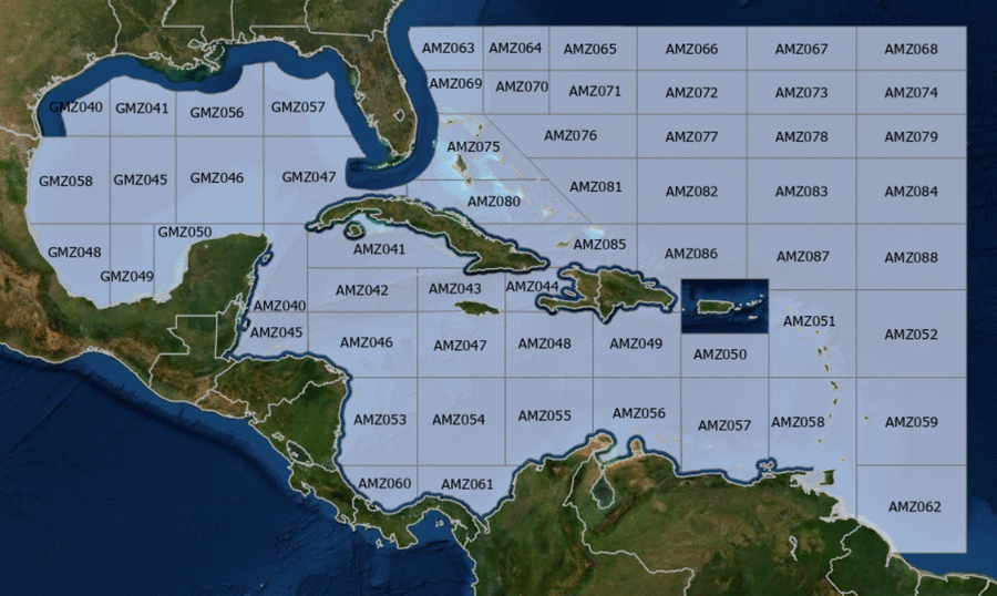
Hover to view popup zone forecast; click a zone to view related text forecast below. Show All Text Below
000
FZNT23 KNHC 180856
OFFNT3

Offshore Waters Forecast for the Caribbean Sea and Tropical
N Atlantic
NWS National Hurricane Center Miami, FL
456 AM EDT Sat May 18 2024

Offshore Waters Forecast for Caribbean Sea, and the Tropical N
Atlantic from 07N to 19N W of 55W.

Seas given as significant wave height, which is the average
height of the highest 1/3 of the waves. Individual waves may be
more than twice the significant wave height.
AMZ001-182100-
Synopsis for Caribbean Sea, and Tropical N Atlantic from 07N to
19N W of 55W
456 AM EDT Sat May 18 2024

.SYNOPSIS...A weak and narrow Atlantic ridge extends westward
along 24N-25N into the NW Bahamas. The associated pressure
gradient between the ridge and lower pressure over SE Mexico is
supporting fresh to strong SE winds across the Gulf of Honduras,
and fresh to locally strong E winds in the south-central
Caribbean. Strong winds in the Gulf of Honduras will persist
through Sun morning, reaching near gale-force this evening into
Sat morning and again Sat night. Fresh to strong winds will pulse
at night in the Gulf of Venezuela and offshore Colombia through
Mon night. High pressure from the eastern Atlantic will build
westward Wed and Wed night leading to increasing trade winds over
most of the central and eastern Caribbean. Dense smoke due to
agricultural fires in Central America continues across areas of
the northwestern Caribbean, and is significantly reducing
visibility across the Gulf of Honduras.
AMZ040-182100-
Caribbean N of 18N W of 85W including Yucatan Basin-
456 AM EDT Sat May 18 2024

.TODAY...SE winds 20 to 25 kt. Seas 6 to 8 ft. Areas of smoke.
Vsby 3 NM.
.TONIGHT...E to SE winds 15 to 20 kt. Seas 5 to 7 ft. Areas of
smoke.
.SUN...SE winds 15 to 20 kt. Seas 4 to 6 ft. Areas of smoke.
.SUN NIGHT...E to SE winds 10 to 15 kt. Seas 3 to 5 ft. Areas of
smoke.
.MON...SE winds 10 to 15 kt. Seas 2 to 4 ft.
.MON NIGHT...E to SE winds 10 to 15 kt. Seas 2 to 4 ft.
.TUE...E to SE winds 10 kt. Seas 2 to 4 ft.
.TUE NIGHT...E to SE winds 10 to 15 kt. Seas 2 to 4 ft.
.WED...E to SE winds 10 to 15 kt. Seas 2 to 4 ft.
.WED NIGHT...E winds 10 to 15 kt. Seas 2 to 4 ft.
Forecaster Stripling
AMZ041-182100-
Caribbean N of 20N E of 85W-
456 AM EDT Sat May 18 2024

.TODAY...SE winds 15 to 20 kt. Seas 3 to 5 ft.
.TONIGHT...SE winds 10 to 15 kt. Seas 2 to 4 ft.
.SUN...SE to S winds 10 to 15 kt. Seas 2 to 4 ft.
.SUN NIGHT...SE to S winds 10 kt, shifting to E late.
Seas 3 ft or less.
.MON...SE winds 10 kt. Seas 3 ft or less.
.MON NIGHT...E to SE winds 10 kt. Seas 3 ft or less.
.TUE...E to SE winds 10 kt. Seas 3 ft or less.
.TUE NIGHT...E to SE winds 10 kt. Seas 3 ft or less.
.WED...E to SE winds 10 kt. Seas 3 ft or less.
.WED NIGHT...E winds 10 to 15 kt. Seas 2 to 4 ft.
Forecaster Stripling
AMZ042-182100-
Caribbean from 18N to 20N between 80W and 85W including Cayman
Basin-
456 AM EDT Sat May 18 2024

.TODAY...SE winds 15 to 20 kt. Seas 3 to 5 ft.
.TONIGHT...E to SE winds 15 to 20 kt. Seas 3 to 5 ft.
.SUN...SE winds 15 to 20 kt. Seas 2 to 4 ft.
.SUN NIGHT...E to SE winds 10 to 15 kt. Seas 2 to 4 ft.
.MON...E to SE winds 10 to 15 kt. Seas 2 to 4 ft.
.MON NIGHT...E winds 10 to 15 kt. Seas 2 to 4 ft.
.TUE...E to SE winds 10 kt. Seas 2 to 4 ft.
.TUE NIGHT...E winds 10 to 15 kt. Seas 2 to 4 ft.
.WED...E winds 10 kt. Seas 2 to 4 ft.
.WED NIGHT...E winds 10 to 15 kt. Seas 3 to 5 ft.
Forecaster Stripling
AMZ043-182100-
Caribbean from 18N to 20N between 76W and 80W-
456 AM EDT Sat May 18 2024

.TODAY...E to SE winds 10 to 15 kt. Seas 2 to 4 ft.
.TONIGHT...E to SE winds 10 to 15 kt. Seas 2 to 4 ft.
.SUN...E to SE winds 10 kt. Seas 2 to 4 ft.
.SUN NIGHT...E winds 10 kt. Seas 3 ft or less. Scattered showers
and isolated tstms.
.MON...E to SE winds 10 to 15 kt. Seas 2 to 4 ft.
.MON NIGHT...E to SE winds 10 to 15 kt. Seas 2 to 4 ft.
.TUE...E to SE winds 10 to 15 kt. Seas 2 to 4 ft.
.TUE NIGHT...E to SE winds 10 to 15 kt. Seas 2 to 4 ft.
.WED...E to SE winds 15 to 20 kt. Seas 4 to 6 ft.
.WED NIGHT...E winds 15 to 20 kt. Seas 5 to 7 ft.
Forecaster Stripling
AMZ044-182100-
Caribbean approaches to the Windward Passage-
456 AM EDT Sat May 18 2024

.TODAY...E winds 10 kt. Seas 3 ft or less.
.TONIGHT...NE to E winds 10 to 15 kt. Seas 3 ft or less.
.SUN...E winds 10 to 15 kt, shifting to S in the afternoon. Seas
2 to 4 ft.
.SUN NIGHT...E winds 10 to 15 kt. Seas 3 ft or less.
.MON...SE winds 10 to 15 kt. Seas 2 to 4 ft.
.MON NIGHT...NE to E winds 10 to 15 kt. Seas 2 to 4 ft.
.TUE...E winds 10 to 15 kt. Seas 2 to 4 ft.
.TUE NIGHT...E to SE winds 15 to 20 kt. Seas 2 to 4 ft.
.WED...E to SE winds 20 to 25 kt. Seas 4 to 6 ft.
.WED NIGHT...E winds 15 to 20 kt. Seas 4 to 6 ft.
Forecaster Stripling
AMZ045-182100-
S of 18N W of 85W including Gulf of Honduras-
456 AM EDT Sat May 18 2024

.TODAY...S of 17N W of 87W, E winds 10 to 15 kt. Seas 3 to 5 ft.
Elsewhere, E to SE winds 20 to 25 kt. Seas 6 to 8 ft. Areas of
smoke. Vsby 3 NM.
.TONIGHT...NE to E winds 15 to 20 kt S of 17N W of 87W, and E to
SE 20 to 25 kt elsewhere. Seas 5 to 7 ft.
.SUN...W winds 10 to 15 kt S of 17N W of 87W, and SE 20 to 25 kt
elsewhere. Seas 4 to 6 ft.
.SUN NIGHT...E winds 10 to 15 kt S of 17N W of 87W, and E 15 to
20 kt elsewhere. Seas 3 to 5 ft.
.MON...E to SE winds 15 to 20 kt. Seas 2 to 4 ft.
.MON NIGHT...E winds 15 to 20 kt. Seas 2 to 4 ft.
.TUE...E winds 10 to 15 kt. Seas 2 to 4 ft.
.TUE NIGHT...E winds 15 kt. Seas 2 to 4 ft.
.WED...E winds 10 to 15 kt. Seas 2 to 4 ft.
.WED NIGHT...E winds 10 to 15 kt. Seas 2 to 4 ft.
Forecaster Stripling
AMZ046-182100-
Caribbean from 15N to 18N between 80W and 85W-
456 AM EDT Sat May 18 2024

.TODAY...E to SE winds 15 to 20 kt. Seas 2 to 4 ft.
.TONIGHT...E to SE winds 15 to 20 kt. Seas 2 to 4 ft.
.SUN...E to SE winds 10 to 15 kt. Seas 2 to 4 ft.
.SUN NIGHT...E winds 10 to 15 kt. Seas 2 to 4 ft.
.MON...E to SE winds 10 to 15 kt. Seas 2 to 4 ft.
.MON NIGHT...E winds 10 to 15 kt. Seas 2 to 4 ft.
.TUE...E to SE winds 10 to 15 kt. Seas 2 to 4 ft.
.TUE NIGHT...E winds 10 to 15 kt. Seas 2 to 4 ft.
.WED...E winds 10 to 15 kt. Seas 2 to 4 ft.
.WED NIGHT...NE to E winds 10 to 15 kt. Seas 2 to 4 ft.
Forecaster Stripling
AMZ047-182100-
Caribbean from 15N to 18N between 76W and 80W-
456 AM EDT Sat May 18 2024

.TODAY...E winds 15 to 20 kt. Seas 2 to 4 ft.
.TONIGHT...E winds 15 to 20 kt. Seas 3 to 5 ft.
.SUN...E winds 15 to 20 kt. Seas 3 to 5 ft.
.SUN NIGHT...E winds 15 to 20 kt. Seas 3 to 5 ft.
.MON...E winds 15 to 20 kt. Seas 4 to 6 ft.
.MON NIGHT...E winds 10 to 15 kt. Seas 4 to 6 ft.
.TUE...E to SE winds 15 to 20 kt. Seas 4 to 6 ft.
.TUE NIGHT...E winds 15 to 20 kt. Seas 4 to 6 ft.
.WED...E to SE winds 15 to 20 kt. Seas 6 to 8 ft.
.WED NIGHT...E to SE winds 10 to 15 kt. Seas 5 to 7 ft.
Forecaster Stripling
AMZ048-182100-
Caribbean from 15N to 18N between 72W and 76W-
456 AM EDT Sat May 18 2024

.TODAY...E winds 15 to 20 kt. Seas 4 to 5 ft.
.TONIGHT...E winds 15 to 20 kt. Seas 4 to 5 ft.
.SUN...E winds 15 to 20 kt. Seas 4 to 6 ft.
.SUN NIGHT...E winds 15 to 20 kt. Seas 4 to 6 ft.
.MON...E winds 15 to 20 kt. Seas 5 to 7 ft.
.MON NIGHT...E winds 15 to 20 kt. Seas 4 to 6 ft.
.TUE...E to SE winds 15 to 20 kt. Seas 4 to 6 ft.
.TUE NIGHT...E winds 15 to 20 kt. Seas 5 to 7 ft.
.WED...E to SE winds 20 to 25 kt. Seas 6 to 9 ft.
.WED NIGHT...SE winds 15 to 20 kt. Seas 6 to 8 ft.
Forecaster Stripling
AMZ049-182100-
Caribbean N of 15N between 68W and 72W-
456 AM EDT Sat May 18 2024

.TODAY...E winds 10 to 15 kt. Seas 2 to 4 ft.
.TONIGHT...E winds 15 to 20 kt. Seas 2 to 4 ft.
.SUN...E winds 10 to 15 kt In Mona Passage, and E 15 to 20 kt
elsewhere. Seas 3 to 5 ft.
.SUN NIGHT...E winds 15 to 20 kt. Seas 3 to 5 ft.
.MON...E winds 15 to 20 kt. Seas 3 to 5 ft.
.MON NIGHT...E to SE winds 15 to 20 kt. Seas 3 to 5 ft.
.TUE...E to SE winds 15 to 20 kt. Seas 4 to 6 ft.
.TUE NIGHT...E winds 15 to 20 kt. Seas 4 to 6 ft.
.WED...E to SE winds 15 to 20 kt. Seas 5 to 7 ft.
.WED NIGHT...E winds 15 to 20 kt. Seas 3 to 5 ft.
Forecaster Stripling
AMZ050-182100-
Caribbean N of 15N between 64W and 68W-
456 AM EDT Sat May 18 2024

.TODAY...E winds 10 to 15 kt. Seas 2 to 4 ft.
.TONIGHT...E winds 10 to 15 kt. Seas 3 to 5 ft.
.SUN...E to SE winds 10 to 15 kt. Seas 3 to 5 ft.
.SUN NIGHT...E winds 10 to 15 kt. Seas 3 to 5 ft.
.MON...E to SE winds 15 kt. Seas 3 to 5 ft.
.MON NIGHT...E to SE winds 15 kt. Seas 3 to 5 ft.
.TUE...E to SE winds 15 kt. Seas 3 to 5 ft.
.TUE NIGHT...E to SE winds 15 kt. Seas 3 to 5 ft.
.WED...E to SE winds 10 to 15 kt. Seas 4 to 6 ft.
.WED NIGHT...E to SE winds 15 to 20 kt. Seas 4 to 6 ft.
Forecaster Stripling
AMZ051-182100-
Offshore Waters Leeward Islands-
456 AM EDT Sat May 18 2024

.TODAY...E to SE winds 10 to 15 kt. Seas 3 to 5 ft. Scattered
showers and isolated tstms.
.TONIGHT...E winds 10 to 15 kt. Seas 3 to 5 ft.
.SUN...E to SE winds 10 to 15 kt. Seas 3 to 5 ft.
.SUN NIGHT...E winds 10 to 15 kt. Seas 3 to 5 ft.
.MON...E to SE winds 10 to 15 kt. Seas 2 to 4 ft.
.MON NIGHT...E winds 10 to 15 kt. Seas 2 to 4 ft.
.TUE...E to SE winds 10 to 15 kt. Seas 2 to 4 ft.
.TUE NIGHT...E to SE winds 15 kt. Seas 2 to 4 ft.
.WED...E to SE winds 15 to 20 kt. Seas 4 to 6 ft.
.WED NIGHT...E winds 15 kt. Seas 4 to 6 ft.
Forecaster Stripling
AMZ052-182100-
Tropical N Atlantic from 15N to 19N between 55W and 60W-
456 AM EDT Sat May 18 2024

.TODAY...E winds 10 to 15 kt. Seas 4 to 6 ft.
.TONIGHT...E winds 10 to 15 kt. Seas 4 to 6 ft.
.SUN...E winds 10 to 15 kt. Seas 4 to 6 ft.
.SUN NIGHT...E winds 10 to 15 kt. Seas 4 to 6 ft.
.MON...E winds 10 to 15 kt. Seas 3 to 5 ft.
.MON NIGHT...E winds 10 to 15 kt. Seas 3 to 5 ft.
.TUE...E winds 15 kt. Seas 3 to 5 ft.
.TUE NIGHT...E winds 15 kt. Seas 4 to 6 ft.
.WED...E winds 15 to 20 kt. Seas 4 to 6 ft.
.WED NIGHT...E winds 15 to 20 kt. Seas 5 to 7 ft.
Forecaster Stripling
AMZ053-182100-
W Central Caribbean from 11N to 15N W of 80W-
456 AM EDT Sat May 18 2024

.TODAY...E winds 10 to 15 kt. Seas 3 to 5 ft. Scattered showers
and isolated tstms.
.TONIGHT...NE to E winds 15 to 20 kt. Seas 3 to 5 ft. Scattered
showers and isolated tstms.
.SUN...NE to E winds 15 to 20 kt. Seas 3 to 5 ft. Isolated
tstms.
.SUN NIGHT...NE to E winds 10 to 15 kt. Seas 3 to 5 ft.
Scattered showers and isolated tstms.
.MON...NE to E winds 10 to 15 kt. Seas 3 to 5 ft.
.MON NIGHT...NE to E winds 10 to 15 kt. Seas 3 to 5 ft.
.TUE...NE to E winds 10 to 15 kt. Seas 2 to 4 ft.
.TUE NIGHT...NE winds 10 kt. Seas 2 to 4 ft.
.WED...N to NE winds 10 kt. Seas 2 to 4 ft.
.WED NIGHT...N to NE winds 10 kt. Seas 2 to 4 ft.
Forecaster Stripling
AMZ054-182100-
Caribbean from 11N to 15N between 76W and 80W-
456 AM EDT Sat May 18 2024

.TODAY...NE to E winds 15 to 20 kt. Seas 5 to 7 ft.
.TONIGHT...NE to E winds 15 to 20 kt. Seas 5 to 7 ft.
.SUN...NE to E winds 15 to 20 kt. Seas 6 to 8 ft.
.SUN NIGHT...NE to E winds 15 to 20 kt. Seas 5 to 7 ft.
.MON...E winds 15 to 20 kt. Seas 5 to 7 ft.
.MON NIGHT...E winds 15 to 20 kt. Seas 4 to 6 ft.
.TUE...E to SE winds 15 to 20 kt. Seas 4 to 6 ft.
.TUE NIGHT...SE to S winds 10 kt. Seas 3 to 5 ft.
.WED...S winds 10 kt. Seas 3 to 5 ft.
.WED NIGHT...S to SW winds 10 kt. Seas 2 to 4 ft.
Forecaster Stripling
AMZ055-182100-
Caribbean from 11N to 15N between 72W and 76W including Colombia
Basin-
456 AM EDT Sat May 18 2024

.TODAY...NE to E winds 20 to 25 kt. Seas 5 to 7 ft.
.TONIGHT...NE to E winds 20 to 25 kt. Seas 6 to 8 ft.
.SUN...NE to E winds 20 to 25 kt. Seas 6 to 8 ft.
.SUN NIGHT...Within 90 nm of coast of Colombia, NE to E winds
15 to 20 kt. Seas 4 to 6 ft. Elsewhere, NE to E winds 20 to
25 kt. Seas 5 to 7 ft.
.MON...E winds 20 to 25 kt. Seas 6 to 8 ft.
.MON NIGHT...E winds 15 to 20 kt. Seas 5 to 7 ft.
.TUE...E to SE winds 15 to 20 kt. Seas 5 to 7 ft.
.TUE NIGHT...SE winds 15 to 20 kt. Seas 4 to 6 ft.
.WED...SE winds 15 to 20 kt. Seas 4 to 6 ft.
.WED NIGHT...E to SE winds 10 to 15 kt. Seas 3 to 5 ft.
Forecaster Stripling
AMZ056-182100-
Caribbean S of 15N between 68W and 72W including Gulf of
Venezuela-
456 AM EDT Sat May 18 2024

.TODAY...E winds 15 to 20 kt. Seas 3 to 5 ft.
.TONIGHT...E winds 20 to 25 kt. Seas 4 to 6 ft.
.SUN...NE to E winds 15 to 20 kt Gulf of Venezuela, and E 20 to
25 kt elsewhere. Seas 5 to 6 ft.
.SUN NIGHT...E winds 20 to 25 kt. Seas 5 to 7 ft.
.MON...E winds 20 to 25 kt. Seas 5 to 7 ft.
.MON NIGHT...E winds 20 to 25 kt. Seas 5 to 7 ft.
.TUE...E to SE winds 15 to 20 kt. Seas 5 to 7 ft.
.TUE NIGHT...E winds 15 to 20 kt. Seas 4 to 6 ft.
.WED...E winds 15 to 20 kt. Seas 4 to 6 ft.
.WED NIGHT...E winds 15 to 20 kt. Seas 3 to 5 ft.
Forecaster Stripling
AMZ057-182100-
Caribbean S of 15N between 64W and 68W including Venezuela Basin-
456 AM EDT Sat May 18 2024

.TODAY...E winds 15 to 20 kt. Seas 3 to 5 ft.
.TONIGHT...E winds 15 to 20 kt. Seas 3 to 5 ft. Scattered
showers and isolated tstms.
.SUN...E to SE winds 15 to 20 kt. Seas 3 to 5 ft.
.SUN NIGHT...E winds 15 to 20 kt. Seas 3 to 5 ft.
.MON...E to SE winds 15 to 20 kt. Seas 3 to 5 ft.
.MON NIGHT...E winds 15 to 20 kt. Seas 3 to 5 ft.
.TUE...E to SE winds 15 to 20 kt. Seas 3 to 5 ft.
.TUE NIGHT...E winds 15 to 20 kt. Seas 3 to 5 ft.
.WED...E to SE winds 15 to 20 kt. Seas 3 to 5 ft.
.WED NIGHT...E winds 15 to 20 kt. Seas 3 to 5 ft.
Forecaster Stripling
AMZ058-182100-
Offshore Waters Windward Islands including Trinidad and Tobago-
456 AM EDT Sat May 18 2024

.TODAY...E winds 15 to 20 kt. Seas 3 to 5 ft. Scattered showers
and isolated tstms.
.TONIGHT...E winds 15 to 20 kt. Seas 3 to 5 ft.
.SUN...E to SE winds 10 to 15 kt. Seas 3 to 5 ft. Scattered
showers and isolated tstms.
.SUN NIGHT...E winds 10 to 15 kt. Seas 3 to 5 ft.
.MON...E winds 10 to 15 kt. Seas 3 to 5 ft.
.MON NIGHT...E winds 10 to 15 kt. Seas 2 to 4 ft.
.TUE...E winds 10 to 15 kt. Seas 2 to 4 ft.
.TUE NIGHT...E winds 15 kt. Seas 2 to 4 ft.
.WED...E to SE winds 15 to 20 kt. Seas 3 to 5 ft.
.WED NIGHT...E winds 15 to 20 kt. Seas 3 to 5 ft.
Forecaster Stripling
AMZ059-182100-
Tropical N Atlantic from 11N and 15N between 55W and 60W-
456 AM EDT Sat May 18 2024

.TODAY...E winds 15 to 20 kt. Seas 5 to 7 ft.
.TONIGHT...E winds 15 to 20 kt. Seas 5 to 7 ft.
.SUN...E winds 10 to 15 kt. Seas 5 to 7 ft. Scattered showers
and isolated tstms.
.SUN NIGHT...E winds 15 kt. Seas 4 to 6 ft.
.MON...E winds 15 kt. Seas 4 to 6 ft.
.MON NIGHT...E winds 15 kt. Seas 3 to 5 ft.
.TUE...E winds 15 kt. Seas 4 to 6 ft.
.TUE NIGHT...E winds 15 to 20 kt. Seas 4 to 6 ft.
.WED...E winds 15 to 20 kt. Seas 5 to 7 ft.
.WED NIGHT...E winds 15 to 20 kt. Seas 5 to 7 ft.
Forecaster Stripling
AMZ060-182100-
SW Caribbean S of 11N W of 80W-
456 AM EDT Sat May 18 2024

.TODAY...S of 10N, NE to E winds 10 kt in the morning, becoming
variable less than 5 kt. Elsewhere, E winds 10 to 15 kt. Seas
2 to 4 ft. Scattered showers and isolated tstms.
.TONIGHT...S of 10N, variable winds less than 5 kt, becoming N
10 kt late. Elsewhere, NE to E winds 10 to 15 kt. Seas
3 to 5 ft. Scattered showers and isolated tstms.
.SUN...S of 10N, variable winds less than 5 kt, becoming NW
10 kt in the afternoon. Elsewhere, NE to E winds 10 to 15 kt.
Seas 3 to 5 ft. Scattered showers and isolated tstms.
.SUN NIGHT...N to NE winds 10 to 15 kt. Seas 3 to 5 ft. Numerous
showers and scattered tstms.
.MON...N winds 10 kt. Seas 3 to 5 ft.
.MON NIGHT...Variable winds less than 5 kt. Seas 3 to 5 ft.
.TUE...Variable winds less than 5 kt. Seas 2 to 4 ft.
.TUE NIGHT...Variable winds less than 5 kt. Seas 2 to 4 ft.
.WED...W winds 10 kt. Seas 2 to 4 ft.
.WED NIGHT...Variable winds less than 5 kt. Seas 3 ft or less.
Forecaster Stripling
AMZ061-182100-
SW Caribbean S of 11N E of 80W including the approaches to the
Panama Canal-
456 AM EDT Sat May 18 2024

.TODAY...S of 10N, NE winds 10 kt in the morning, becoming
variable less than 5 kt. Elsewhere, NE to E winds 15 to 20 kt.
Seas 2 to 4 ft S of 10N, and 4 to 6 ft elsewhere. Scattered
showers and isolated tstms.
.TONIGHT...N to NE winds 10 kt S of 10N, and NE 15 to 20 kt
elsewhere. Seas 3 to 5 ft. Scattered showers and isolated tstms.
.SUN...S of 10N, SE winds 10 kt, shifting to W in the afternoon.
Elsewhere, NE to E winds 15 to 20 kt. Seas 3 to 5 ft S of 10N,
and 5 to 7 ft elsewhere. Scattered showers and isolated tstms.
.SUN NIGHT...Variable winds less than 5 kt S of 10N, and NE
10 to 15 kt elsewhere. Seas 4 to 6 ft. Scattered showers and
isolated tstms.
.MON...S winds 10 kt. Seas 3 to 5 ft.
.MON NIGHT...SW to W winds 10 kt. Seas 2 to 4 ft.
.TUE...S to SW winds 10 kt. Seas 2 to 4 ft.
.TUE NIGHT...S winds 10 kt. Seas 2 to 4 ft.
.WED...SW winds 10 kt. Seas 2 to 4 ft.
.WED NIGHT...S to SW winds 10 kt. Seas 3 ft or less.
Forecaster Stripling
AMZ062-182100-
Tropical N Atlantic from 7N and 11N between 55W and 60W-
456 AM EDT Sat May 18 2024

.TODAY...E winds 10 to 15 kt. Seas 4 to 6 ft. Scattered showers
and isolated tstms.
.TONIGHT...E winds 15 to 20 kt. Seas 5 to 7 ft. Scattered
showers and isolated tstms.
.SUN...E winds 10 to 15 kt. Seas 5 to 7 ft. Scattered showers
and isolated tstms.
.SUN NIGHT...E winds 10 to 15 kt. Seas 4 to 6 ft. Scattered
showers and isolated tstms.
.MON...E winds 15 kt. Seas 4 to 6 ft.
.MON NIGHT...E winds 15 kt. Seas 3 to 5 ft.
.TUE...E winds 15 kt. Seas 3 to 5 ft.
.TUE NIGHT...E winds 15 to 20 kt. Seas 3 to 5 ft.
.WED...E winds 15 kt. Seas 4 to 6 ft.
.WED NIGHT...E winds 15 kt. Seas 4 to 6 ft.
Forecaster Stripling
041
FZNT25 KNHC 181408
OFFNT5

Offshore Waters Forecast for the SW N Atlantic including the
Bahamas
NWS National Hurricane Center Miami, FL
1008 AM EDT Sat May 18 2024

Offshore Waters Forecast for the SW N Atlantic from 19N to 31N W
of 55W including Bahamas.

Seas given as significant wave height, which is the average
height of the highest 1/3 of the waves. Individual waves may be
more than twice the significant wave height.
AMZ101-190215-
Synopsis for the SW N Atlantic including the Bahamas
1008 AM EDT Sat May 18 2024

.SYNOPSIS...A frontal trough extends from 31N59W southwestward
to 26N70W and northwestward to 30N80W. Clusters of scattered
showers and thunderstorms continue along the front E of 65W. The
cold front will move slowly eastward, and shift east of 55W early
Mon, with active weather expected to continue ahead of the front
through Sun. Moderate to locally fresh winds and moderate seas
are expected across most of the area through Sun night as weak
high pressure extends E to W roughly along 24N-25N. A new front
will sink southward into the waters offshore of Georgia and NE
Florida early Mon, and move southeastward and weaken through late
Tue. A residual trough may linger from near 30N71W to the
central Bahamas Wed and Wed night.
AMZ063-190215-
Atlantic from 29N to 31N W of 77W-
1008 AM EDT Sat May 18 2024

.TODAY...SW to W winds 10 kt. Seas 3 to 4 ft.
.TONIGHT...S to SW winds 15 to 20 kt. Seas 2 to 4 ft. Scattered
showers and isolated thunderstorms.
.SUN...W winds 15 to 20 kt. Seas 3 to 5 ft. Scattered showers
and isolated thunderstorms.
.SUN NIGHT...NW winds 10 to 15 kt. Seas 3 to 5 ft. Scattered
showers and isolated thunderstorms.
.MON...N winds 10 to 15 kt. Seas 4 to 6 ft.
.MON NIGHT...N to NE winds 15 to 20 kt. Seas 4 to 6 ft.
.TUE...NE winds 10 to 15 kt. Seas 4 to 6 ft.
.TUE NIGHT...NE to E winds 10 to 15 kt. Seas 3 to 5 ft.
.WED...NE to E winds 10 kt. Seas 3 to 4 ft.
.WED NIGHT...E winds 10 kt. Seas 3 to 4 ft.
Forecaster Aguirre
AMZ064-190215-
Atlantic from 29N to 31N between 74W and 77W-
1008 AM EDT Sat May 18 2024

.TODAY...S to SW winds 10 kt. Seas 3 to 4 ft. Isolated showers
and thunderstorms.
.TONIGHT...S to SW winds 10 to 15 kt. Seas 2 to 4 ft. Scattered
showers and isolated thunderstorms.
.SUN...SW to W winds 15 to 20 kt. Seas 3 to 5 ft. Scattered
showers and isolated thunderstorms.
.SUN NIGHT...SW to W winds 10 to 15 kt. Seas 4 to 6 ft.
Scattered showers and isolated thunderstorms.
.MON...W to NW winds 10 to 15 kt. Seas 3 to 5 ft.
.MON NIGHT...N to NE winds 10 to 15 kt. Seas 3 to 5 ft.
.TUE...NE winds 10 to 15 kt. Seas 3 to 5 ft.
.TUE NIGHT...NE to E winds 10 to 15 kt. Seas 3 to 5 ft.
.WED...NE winds 10 kt. Seas 2 to 4 ft.
.WED NIGHT...E winds 10 kt. Seas 2 to 4 ft.
Forecaster Aguirre
AMZ065-190215-
Atlantic from 29N to 31N between 70W and 74W-
1008 AM EDT Sat May 18 2024

.TODAY...SW winds 10 kt. Seas 3 to 5 ft in N swell.
.TONIGHT...SW winds 10 kt. Seas 3 to 5 ft in N swell.
.SUN...SW winds 10 to 15 kt. Seas 3 to 4 ft. Scattered showers
and isolated thunderstorms.
.SUN NIGHT...SW to W winds 10 to 15 kt. Seas 3 to 5 ft.
.MON...SW to W winds 10 to 15 kt. Seas 3 to 5 ft.
.MON NIGHT...W winds 10 to 15 kt. Seas 3 to 5 ft.
.TUE...N winds 10 kt. Seas 3 to 5 ft.
.TUE NIGHT...NE winds 10 kt. Seas 3 to 5 ft.
.WED...Variable winds less than 5 kt. Seas 2 to 4 ft.
.WED NIGHT...Variable winds less than 5 kt. Seas 2 to 4 ft.
Forecaster Aguirre
AMZ066-190215-
Atlantic from 29N to 31N between 65W and 70W-
1008 AM EDT Sat May 18 2024

.TODAY...W winds 10 to 15 kt. Seas 4 to 6 ft.
.TONIGHT...W winds 10 to 15 kt. Seas 3 to 5 ft.
.SUN...SW winds 10 to 15 kt. Seas 3 to 5 ft.
.SUN NIGHT...SW winds 10 to 15 kt. Seas 3 to 5 ft. Scattered
showers and isolated thunderstorms.
.MON...SW winds 15 to 20 kt. Seas 3 to 5 ft.
.MON NIGHT...SW winds 10 to 15 kt. Seas 3 to 5 ft.
.TUE...SW winds 10 to 15 kt. Seas 2 to 4 ft.
.TUE NIGHT...S to SW winds 10 kt. Seas 2 to 4 ft.
.WED...S to SW winds 10 kt. Seas 2 to 4 ft.
.WED NIGHT...S to SW winds 10 kt. Seas 2 to 4 ft.
Forecaster Aguirre
AMZ067-190215-
Atlantic from 29N to 31N between 60W and 65W-
1008 AM EDT Sat May 18 2024

.TODAY...SW to W winds 10 to 15 kt. Seas 4 to 6 ft.
.TONIGHT...W winds 10 to 15 kt. Seas 3 to 5 ft.
.SUN...W winds 10 to 15 kt. Seas 3 to 5 ft.
.SUN NIGHT...SW to W winds 10 to 15 kt. Seas 3 to 5 ft.
.MON...SW winds 10 to 15 kt. Seas 3 to 5 ft.
.MON NIGHT...SW winds 10 to 15 kt. Seas 2 to 4 ft.
.TUE...SW winds 10 to 15 kt. Seas 2 to 4 ft.
.TUE NIGHT...S to SW winds 10 kt. Seas 2 to 4 ft.
.WED...S to SW winds 10 kt. Seas 2 to 4 ft.
.WED NIGHT...S to SW winds 10 kt. Seas 2 to 4 ft.
Forecaster Aguirre
AMZ068-190215-
Atlantic from 29N to 31N between 55W and 60W-
1008 AM EDT Sat May 18 2024

.TODAY...SW winds 10 to 15 kt. Seas 3 to 5 ft. Scattered showers
and isolated thunderstorms.
.TONIGHT...SW to W winds 10 to 15 kt. Seas 4 to 6 ft. Scattered
showers and isolated thunderstorms.
.SUN...SW to W winds 10 to 15 kt. Seas 3 to 5 ft. Scattered
showers and isolated thunderstorms.
.SUN NIGHT...W winds 10 kt. Seas 3 to 5 ft.
.MON...SW to W winds 10 to 15 kt. Seas 3 to 5 ft.
.MON NIGHT...SW winds 10 to 15 kt. Seas 3 to 5 ft.
.TUE...SW winds 10 to 15 kt. Seas 3 to 5 ft.
.TUE NIGHT...SW winds 10 kt. Seas 3 to 4 ft.
.WED...SW winds 10 kt. Seas 3 to 4 ft.
.WED NIGHT...SW winds 10 kt. Seas 3 to 4 ft.
Forecaster Aguirre
AMZ069-190215-
Atlantic from 27N to 29N W of 77W-
1008 AM EDT Sat May 18 2024

.TODAY...SW winds 10 kt. Seas 3 to 4 ft. Scattered showers and
isolated thunderstorms.
.TONIGHT...S winds 10 kt, becoming S to SW 15 to 20 kt late.
Seas 2 to 4 ft. Scattered showers and isolated thunderstorms.
.SUN...SW to W winds 15 to 20 kt. Seas 2 to 4 ft. Scattered
showers and isolated thunderstorms.
.SUN NIGHT...SW to W winds 10 to 15 kt. Seas 2 to 4 ft.
Scattered showers and isolated thunderstorms.
.MON...W winds 10 kt. Seas 2 to 4 ft.
.MON NIGHT...N winds 10 to 15 kt. Seas 2 to 4 ft.
.TUE...N to NE winds 10 kt. Seas 2 to 4 ft.
.TUE NIGHT...NE to E winds 10 to 15 kt. Seas 2 to 4 ft.
.WED...NE to E winds 10 kt. Seas 2 to 4 ft.
.WED NIGHT...E winds 10 kt. Seas 2 to 4 ft.
Forecaster Aguirre
AMZ070-190215-
Atlantic from 27N to 29N between 74W and 77W-
1008 AM EDT Sat May 18 2024

.TODAY...S to SW winds 10 kt. Seas 3 to 4 ft. Isolated showers
and thunderstorms.
.TONIGHT...S to SW winds 10 to 15 kt. Seas 3 to 5 ft. Isolated showers
and thunderstorms.
.SUN...SW winds 15 to 20 kt. Seas 2 to 4 ft. Scattered showers
and isolated thunderstorms.
.SUN NIGHT...SW winds 10 to 15 kt. Seas 3 to 5 ft. Scattered
showers and isolated thunderstorms.
.MON...SW to W winds 15 to 20 kt. Seas 3 to 5 ft.
.MON NIGHT...NW winds 10 kt. Seas 2 to 4 ft.
.TUE...Variable winds less than 5 kt. Seas 2 to 4 ft.
.TUE NIGHT...NE to E winds 10 kt. Seas 2 to 4 ft.
.WED...NE to E winds 10 kt. Seas 2 to 4 ft.
.WED NIGHT...E winds 10 kt. Seas 2 to 4 ft.
Forecaster Aguirre
AMZ071-190215-
Atlantic from 27N to 29N between 70W and 74W-
1008 AM EDT Sat May 18 2024

.TODAY...Variable winds less than 5 kt. Seas 3 to 4 ft in N swell.
.TONIGHT...Variable winds less than 5 kt, becoming S to SW 10 kt
late. Seas 3 to 4 ft.
.SUN...SW winds 10 to 15 kt. Seas 3 to 5 ft. Scattered showers
and isolated thunderstorms.
.SUN NIGHT...SW winds 10 to 15 kt. Seas 3 to 5 ft. Scattered
showers and isolated thunderstorms.
.MON...SW winds 15 kt. Seas 3 to 5 ft.
.MON NIGHT...SW winds 10 to 15 kt. Seas 3 to 5 ft.
.TUE...SW to W winds 10 to 15 kt. Seas 2 to 4 ft.
.TUE NIGHT...S to SW winds 10 kt. Seas 2 to 4 ft.
.WED...S winds 10 kt. Seas 2 to 4 ft.
.WED NIGHT...SE to S winds 10 kt. Seas 2 to 4 ft.
Forecaster Aguirre
AMZ072-190215-
Atlantic from 27N to 29N between 65W and 70W-
1008 AM EDT Sat May 18 2024

.TODAY...W winds 10 kt. Seas 3 to 5 ft in NW to N swell.
.TONIGHT...NW winds 10 kt in the evening, becoming variable less
than 5 kt. Seas 3 to 5 ft in NW to N swell.
.SUN...Variable winds less than 5 kt, becoming SW to W 10 kt in
the afternoon. Seas 3 to 4 ft.
.SUN NIGHT...SW winds 10 to 15 kt. Seas 3 to 4 ft.
.MON...SW winds 10 to 15 kt. Seas 3 to 5 ft.
.MON NIGHT...S to SW winds 10 to 15 kt. Seas 3 to 5 ft.
.TUE...S to SW winds 10 to 15 kt. Seas 3 to 5 ft.
.TUE NIGHT...S to SW winds 10 to 15 kt. Seas 3 to 5 ft.
.WED...S to SW winds 10 kt. Seas 3 to 4 ft.
.WED NIGHT...S to SW winds 10 kt. Seas 3 to 4 ft.
Forecaster Aguirre
AMZ073-190215-
Atlantic from 27N to 29N between 60W and 65W-
1008 AM EDT Sat May 18 2024

.TODAY...SW to W winds 10 to 15 kt. Seas 3 to 5 ft.
.TONIGHT...W winds 10 to 15 kt. Seas 3 to 5 ft.
.SUN...W winds 10 kt. Seas 3 to 5 ft.
.SUN NIGHT...SW to W winds 10 kt. Seas 2 to 4 ft.
.MON...SW winds 10 to 15 kt. Seas 2 to 4 ft.
.MON NIGHT...SW winds 10 kt. Seas 3 ft or less.
.TUE...S to SW winds 10 kt. Seas 2 to 4 ft.
.TUE NIGHT...S winds 10 kt. Seas 2 to 4 ft.
.WED...S winds 10 kt. Seas 2 to 4 ft.
.WED NIGHT...S winds 10 kt. Seas 2 to 4 ft.
Forecaster Aguirre
AMZ074-190215-
Atlantic from 27N to 29N between 55W and 60W-
1008 AM EDT Sat May 18 2024

.TODAY...S to SW winds 10 kt. Seas 3 to 5 ft in SE swell.
.TONIGHT...SW winds 10 to 15 kt. Seas 3 to 5 ft.
.SUN...SW to W winds 10 to 15 kt. Seas 3 to 5 ft.
.SUN NIGHT...SW to W winds 10 kt. Seas 3 to 5 ft.
.MON...SW to W winds 10 kt. Seas 2 to 4 ft.
.MON NIGHT...SW winds 10 kt. Seas 3 ft or less.
.TUE...SW winds 10 kt. Seas 3 ft or less.
.TUE NIGHT...S to SW winds 10 kt. Seas 3 ft or less.
.WED...S winds 10 kt. Seas 3 ft or less.
.WED NIGHT...S winds 10 kt. Seas 3 ft or less.
Forecaster Aguirre
AMZ075-190215-
Northern Bahamas from 24N to 27N-
1008 AM EDT Sat May 18 2024

.TODAY...Variable winds less than 5 kt. Seas 2 to 3 ft in mixed
swell. Isolated showers and thunderstorms.
.TONIGHT...SE winds 10 to 15 kt. Seas 3 to 4 ft. Isolated showers
and thunderstorms.
.SUN...S winds 10 kt. Seas 3 ft or less. Scattered showers and
isolated thunderstorms.
.SUN NIGHT...S winds 10 kt. Seas 3 ft or less. Scattered showers
and isolated thunderstorms.
.MON...SW winds 10 to 15 kt. Seas 3 ft or less.
.MON NIGHT...W to NW winds 10 kt. Seas 3 ft or less.
.TUE...Variable winds less than 5 kt. Seas 3 ft or less.
.TUE NIGHT...Variable winds less than 5 kt. Seas 3 ft or less.
.WED...Variable winds less than 5 kt. Seas 3 ft or less.
.WED NIGHT...E to SE winds 10 kt. Seas 3 ft or less.
Forecaster Aguirre
AMZ076-190215-
Atlantic from 22N to 27N E of Bahamas to 70W-
1008 AM EDT Sat May 18 2024

.TODAY...Variable winds less than 5 kt. Seas 3 to 4 ft in E to SE
swell.
.TONIGHT...Variable winds less than 5 kt, becoming S 10 kt
late. Seas 2 to 4 ft.
.SUN...S to SW winds 10 kt. Seas 2 to 4 ft.
.SUN NIGHT...S to SW winds 10 to 15 kt. Seas 2 to 4 ft.
.MON...S to SW winds 10 to 15 kt. Seas 2 to 4 ft.
.MON NIGHT...SW winds 10 kt. Seas 2 to 4 ft.
.TUE...SW winds 10 kt. Seas 2 to 4 ft.
.TUE NIGHT...SE to S winds 10 kt. Seas 2 to 4 ft.
.WED...SE winds 10 kt. Seas 2 to 4 ft.
.WED NIGHT...S winds 10 kt. Seas 2 to 4 ft.
Forecaster Aguirre
AMZ077-190215-
Atlantic from 22N to 27N between 65W and 70W-
1008 AM EDT Sat May 18 2024

.TODAY...SW to W winds 10 kt. Seas 3 to 4 ft.
.TONIGHT...W to NW winds 10 kt in the evening, becoming variable
less than 5 kt. Seas 3 to 4 ft.
.SUN...Variable winds less than 5 kt, becoming SW to W 10 kt in
the afternoon. Seas 3 to 4 ft.
.SUN NIGHT...Variable winds less than 5 kt, becoming S to SW
10 kt late. Seas 3 to 4 ft.
.MON...S to SW winds 10 kt. Seas 3 to 4 ft.
.MON NIGHT...S to SW winds 10 kt. Seas 3 to 4 ft.
.TUE...S winds 10 to 15 kt. Seas 3 to 4 ft.
.TUE NIGHT...S winds 10 kt. Seas 3 to 4 ft.
.WED...S winds 10 to 15 kt. Seas 3 to 4 ft.
.WED NIGHT...S winds 10 kt. Seas 3 to 4 ft.
Forecaster Aguirre
AMZ078-190215-
Atlantic from 25N to 27N between 60W and 65W-
1008 AM EDT Sat May 18 2024

.TODAY...SW winds 10 kt. Seas 3 to 5 ft in SE swell.
.TONIGHT...SW to W winds 10 kt. Seas 3 to 4 ft.
.SUN...SW to W winds 10 kt. Seas 3 to 4 ft.
.SUN NIGHT...Variable winds less than 5 kt, becoming S to SW
10 kt late. Seas 3 to 4 ft.
.MON...S to SW winds 10 kt. Seas 3 to 4 ft.
.MON NIGHT...S to SW winds 10 kt. Seas 3 to 4 ft.
.TUE...S winds 10 to 15 kt. Seas 3 to 4 ft.
.TUE NIGHT...SE to S winds 10 kt. Seas 3 to 4 ft.
.WED...SE to S winds 10 kt. Seas 3 to 4 ft.
.WED NIGHT...SE to S winds 10 kt. Seas32 to 4 ft.
Forecaster Aguirre
AMZ079-190215-
Atlantic from 25N to 27N between 55W and 60W-
1008 AM EDT Sat May 18 2024

.TODAY...S to SW winds 10 kt.  Seas 2 to 4 ft.
.TONIGHT...SW winds 10 kt. Seas 2 to 4 ft.
.SUN...SW winds 10 kt. Seas 2 to 4 ft. Scattered showers and
isolated thunderstorms.
.SUN NIGHT...SW to W winds 10 kt. Seas 2 to 4 ft.
.MON...SW winds 10 kt. Seas 2 to 4 ft.
.MON NIGHT...Variable winds less than 5 kt. Seas 3 ft or less.
.TUE...S winds 10 kt. Seas 3 ft or less.
.TUE NIGHT...SE to S winds 10 kt. Seas 3 ft or less.
.WED...SE winds 10 kt. Seas 3 ft or less.
.WED NIGHT...SE winds 10 kt. Seas 3 ft or less.
Forecaster Aguirre
AMZ080-190215-
Central Bahamas including Cay Sal Bank-
1008 AM EDT Sat May 18 2024

.TODAY...E to SE winds 10 kt. Seas 2 to 4 ft.
.TONIGHT...E winds 10 to 15 kt. Seas 3 to 4 ft.
.SUN...SE winds 10 to 15 kt. Seas 3 to 4 ft.
.SUN NIGHT...E to SE winds 10 to 15 kt. Seas 3 ft or less.
.MON...SE to S winds 10 kt. Seas 3 ft or less.
.MON NIGHT...S to SW winds 10 kt. Seas 3 ft or less.
.TUE...Variable winds less than 5 kt. Seas 3 ft or less.
.TUE NIGHT...Variable winds less than 5 kt. Seas 3 ft or less.
.WED...E winds 10 kt. Seas 3 ft or less.
.WED NIGHT...E to SE winds 10 to 15 kt. Seas 3 ft or less.
Forecaster Aguirre
AMZ081-190215-
Atlantic from 22N to 25N E of Bahamas to 70W-
1008 AM EDT Sat May 18 2024

.TODAY...SE to S winds 10 kt. Seas 3 ft or less.
.TONIGHT...Variable winds less than 5 kt N of 25N, and NE to E
10 kt elsewhere. Seas 2 to 4 ft.
.SUN...SE winds 10 kt. Seas 2 to 4 ft.
.SUN NIGHT...N of 25N, variable winds less than 5 kt, becoming
SE to S 10 kt late. Elsewhere, SE winds 10 kt. Seas
2 to 4 ft.
.MON...SE to S winds 10 kt. Seas 2 to 4 ft.
.MON NIGHT...SE to S winds 10 to 15 kt. Seas 3 ft or less.
.TUE...SE to S winds 10 kt. Seas 2 to 4 ft.
.TUE NIGHT...SE winds 10 kt. Seas 2 to 4 ft.
.WED...E to SE winds 10 to 15 kt. Seas 2 to 4 ft.
.WED NIGHT...SE winds 10 to 15 kt. Seas 3 to 5 ft.
Forecaster Aguirre
AMZ082-190215-
Atlantic from 22N to 25N between 65W and 70W-
1008 AM EDT Sat May 18 2024

.TODAY...Variable winds less than 5 kt. Seas 3 to 4 ft in E swell.
.TONIGHT...Variable winds less than 5 kt, becoming E 10 kt late.
Seas 3 to 4 ft in E swell.
.SUN...SE to S winds 10 kt in the morning, becoming variable
less than 5 kt. Seas 3 to 4 ft.
.SUN NIGHT...E to SE winds 10 kt. Seas 3 to 4 ft.
.MON...SE to S winds 10 kt. Seas 3 to 4 ft.
.MON NIGHT...SE to S winds 10 to 15 kt. Seas 3 to 5 ft.
.TUE...SE to S winds 10 to 15 kt. Seas 3 to 5 ft.
.TUE NIGHT...SE to S winds 10 to 15 kt. Seas 3 to 5 ft.
.WED...SE winds 10 to 15 kt. Seas 3 to 5 ft.
.WED NIGHT...SE winds 10 to 15 kt. Seas 3 to 5 ft.
Forecaster Aguirre
AMZ083-190215-
Atlantic from 22N to 25N between 60W and 65W-
1008 AM EDT Sat May 18 2024

.TODAY...Variable winds less than 5 kt. Seas 3 to 4 ft in mixed
NE and SE swell.
.TONIGHT...Variable winds less than 5 kt. Seas 3 to 4 ft in mixed
NE and SE swell.
.SUN...Variable winds less than 5 kt. Seas 3 to 4 ft in SE swell.
.SUN NIGHT...Variable winds less than 5 kt, coming SE 10 kt
late. Seas 3 to 4 ft.
.MON...SE to S winds 10 kt. Seas 3 to 4 ft.
.MON NIGHT...SE winds 10 kt. Seas 3 ft or less.
.TUE...SE winds 10 to 15 kt. Seas 2 to 4 ft.
.TUE NIGHT...SE winds 10 to 15 kt. Seas 2 to 4 ft.
.WED...SE winds 10 to 15 kt. Seas 2 to 4 ft.
.WED NIGHT...SE winds 10 to 15 kt. Seas 3 to 5 ft.
Forecaster Aguirre
AMZ084-190215-
Atlantic from 22N to 25N between 55W and 60W-
1008 AM EDT Sat May 18 2024

.TODAY...Variable winds less than 5 kt. Seas 3 to 4 ft in mixed
NE and SE swell.
.TONIGHT...Variable winds less than 5 kt. Seas 3 to 4 ft in SE
swell.
.SUN...S winds 10 kt. Seas 3 to 4 ft. Scattered showers and
isolated thunderstorms.
.SUN NIGHT...Variable winds less than 5 kt. Seas 3 to 4 ft in SE
swell.
.MON...S winds 10 kt. Seas 3 to 4 ft.
.MON NIGHT...SE winds 10 kt. Seas 3 ft or less.
.TUE...SE winds 10 kt. Seas 3 ft or less.
.TUE NIGHT...E to SE winds 10 to 15 kt. Seas 2 to 4 ft.
.WED...E to SE winds 10 to 15 kt. Seas 2 to 4 ft.
.WED NIGHT...E to SE winds 10 to 15 kt. Seas 2 to 4 ft.
Forecaster Aguirre
AMZ085-190215-
Atlantic S of 22N W of 70W including approaches to the Windward
Passage-
1008 AM EDT Sat May 18 2024

.TODAY...E winds 10 kt. Seas 3 to 4 ft.
.TONIGHT...E winds 10 to 15 kt. Seas 2 to 4 ft.
.SUN...E to SE winds 10 to 15 kt. Seas 2 to 4 ft.
.SUN NIGHT...E winds 10 to 15 kt. Seas 2 to 4 ft.
.MON...SE winds 10 to 15 kt. Seas 2 to 4 ft.
.MON NIGHT...SE winds 10 to 15 kt. Seas 3 ft or less.
.TUE...NE to E winds 10 to 15 kt. Seas 3 ft or less.
.TUE NIGHT...SE winds 10 to 15 kt. Seas 3 ft or less.
.WED...SE winds 10 to 15 kt. Seas 3 ft or less.
.WED NIGHT...E winds 10 to 15 kt. Seas 3 ft or less.
Forecaster Aguirre
AMZ086-190215-
Atlantic S of 22N between 65W and 70W including Puerto Rico
Trench-
1008 AM EDT Sat May 18 2024

.TODAY...E to SE winds 10 kt. Seas 3 to 4 ft.
.TONIGHT...E winds 10 to 15 kt. Seas 2 to 4 ft.
.SUN...E to SE winds 10 kt. Seas 2 to 4 ft.
.SUN NIGHT...E to SE winds 10 to 15 kt. Seas 2 to 4 ft.
.MON...SE winds 10 to 15 kt. Seas 2 to 4 ft.
.MON NIGHT...SE winds 10 to 15 kt. Seas 2 to 4 ft.
.TUE...SE winds 10 to 15 kt. Seas 2 to 4 ft.
.TUE NIGHT...SE winds 10 to 15 kt. Seas 2 to 4 ft.
.WED...SE winds 10 to 15 kt. Seas 2 to 4 ft.
.WED NIGHT...SE winds 10 to 15 kt. Seas 2 to 4 ft.
Forecaster Aguirre
AMZ087-190215-
Atlantic from 19N to 22N between 60W and 65W-
1008 AM EDT Sat May 18 2024

.TODAY...E to SE winds 10 kt. Seas 3 to 5 ft in SE swell.
.TONIGHT...E to SE winds 10 kt. Seas 3 to 5 ft in SE swell.
.SUN...E to SE winds 10 kt. Seas 3 to 5 ft in SE swell.
.SUN NIGHT...E winds 10 kt. Seas 3 to 4 ft.
.MON...SE winds 10 kt. Seas 3 to 4 ft.
.MON NIGHT...E to SE winds 10 to 15 kt. Seas 3 to 5 ft.
.TUE...E to SE winds 10 to 15 kt. Seas 3 to 5 ft.
.TUE NIGHT...E to SE winds 10 to 15 kt. Seas 3 to 5 ft.
.WED...E to SE winds 10 to 15 kt. Seas 3 to 5 ft.
.WED NIGHT...E to SE winds 10 to 15 kt. Seas 4 to 6 ft.
Forecaster Aguirre
AMZ088-190215-
Atlantic from 19N to 22N between 55W and 60W-
1008 AM EDT Sat May 18 2024

.TODAY...E to SE winds 10 kt. Seas 3 to 5 ft in SE swell.
.TONIGHT...E to SE winds 10 kt. Seas 3 to 5 ft in SE swell.
.SUN...E to SE winds 10 kt. Seas 3 to 5 ft.
.SUN NIGHT...E to SE winds 10 kt. Seas 2 to 4 ft. Scattered
showers and isolated thunderstorms.
.MON...E to SE winds 10 kt. Seas 2 to 4 ft.
.MON NIGHT...E winds 10 to 15 kt. Seas 2 to 4 ft.
.TUE...E to SE winds 10 to 15 kt. Seas 2 to 4 ft.
.TUE NIGHT...E to SE winds 10 to 15 kt. Seas 3 to 5 ft.
.WED...E to SE winds 15 kt. Seas 3 to 5 ft.
.WED NIGHT...E winds 15 kt. Seas 3 to 5 ft.
Forecaster Aguirre
000
FZNT24 KNHC 180857
OFFNT4

Offshore Waters Forecast for the Gulf of Mexico
NWS National Hurricane Center Miami, FL
457 AM EDT Sat May 18 2024

Offshore Waters Forecast for the Gulf of Mexico

Seas given as significant wave height, which is the average
height of the highest 1/3 of the waves. Individual waves may be
more than twice the significant wave height.
GMZ001-182100-
Synopsis for the Gulf of Mexico
457 AM EDT Sat May 18 2024

.SYNOPSIS...A weak cold front has stalled across the western
Gulf, from southeastern Louisiana to the extreme NE coast of
Mexico. Scattered showers and thunderstorms are over the Gulf
waters from Louisiana to Alabama along and north of the front.
The front will shift eastward across the northern Gulf through
early Sun, then stall and weaken gradually through Mon. Upper-
level disturbances moving from W to E across the Gulf coast
states will maintain active weather over the northern Gulf
through the weekend. Elsewhere, moderate to fresh return flow
will dominate the basin through early Sun, pulsing to locally
strong near the Yucatan Peninsula and the Bay of Campeche. Winds
will slightly weaken Sun into early next week as the pressure
gradient relaxes. Meanwhile, areas of haze and smoke due to
agricultural fires in Mexico continue across most of the western
Gulf and Bay of Campeche. Moderate to locally fresh SE return
flow will develop again across the W Gulf Tue and Wed.
GMZ040-182100-
NW Gulf including Stetson Bank-
457 AM EDT Sat May 18 2024

.TODAY...NE to E winds 10 kt. Seas 3 to 5 ft. Areas of smoke.
Scattered showers and isolated tstms.
.TONIGHT...NE to E winds 10 to 15 kt. Seas 2 to 4 ft.
.SUN...E winds 10 kt. Seas 2 to 4 ft.
.SUN NIGHT...E winds 10 to 15 kt. Seas 2 to 4 ft.
.MON...SE winds 10 kt. Seas 2 to 4 ft.
.MON NIGHT...SE winds 10 to 15 kt. Seas 2 to 4 ft.
.TUE...SE winds 15 kt. Seas 2 to 4 ft.
.TUE NIGHT...SE winds 15 to 20 kt. Seas 3 to 5 ft.
.WED...SE to S winds 15 to 20 kt. Seas 4 to 6 ft.
.WED NIGHT...SE winds 15 to 20 kt. Seas 4 to 6 ft.
Forecaster Stripling
GMZ041-182100-
SW Louisiana Offshore Waters including Flower Garden Bank Marine
Sanctuary-
457 AM EDT Sat May 18 2024

.TODAY...E winds 15 to 20 kt. Seas 3 to 5 ft. Areas of smoke.
Vsby 3 NM. Scattered showers and isolated tstms.
.TONIGHT...E winds 10 to 15 kt. Seas 3 to 5 ft.
.SUN...NE to E winds 10 kt. Seas 3 to 5 ft.
.SUN NIGHT...E winds 10 to 15 kt. Seas 2 to 4 ft.
.MON...E to SE winds 10 kt. Seas 3 ft or less.
.MON NIGHT...E to SE winds 10 to 15 kt. Seas 3 ft or less.
.TUE...SE winds 15 kt. Seas 2 to 4 ft.
.TUE NIGHT...SE winds 15 kt. Seas 2 to 4 ft.
.WED...SE winds 15 kt. Seas 3 to 5 ft.
.WED NIGHT...SE winds 10 to 15 kt. Seas 3 to 5 ft.
Forecaster Stripling
GMZ045-182100-
W Central Gulf from 22N to 26N between 91W and 94W-
457 AM EDT Sat May 18 2024

.TODAY...E to SE winds 15 to 20 kt, shifting to SE 10 kt in the
afternoon. Seas 3 to 5 ft. Areas of smoke. Vsby 3 NM.
.TONIGHT...E winds 10 kt. Seas 3 to 5 ft.
.SUN...E winds 10 kt. Seas 2 to 4 ft.
.SUN NIGHT...NE to E winds 10 to 15 kt. Seas 2 to 4 ft.
.MON...SE winds 10 kt. Seas 3 ft or less.
.MON NIGHT...E winds 10 to 15 kt. Seas 3 ft or less.
.TUE...E to SE winds 10 to 15 kt. Seas 2 to 4 ft.
.TUE NIGHT...E to SE winds 15 to 20 kt. Seas 2 to 4 ft.
.WED...SE winds 15 to 20 kt. Seas 3 to 5 ft.
.WED NIGHT...E to SE winds 15 to 20 kt. Seas 3 to 5 ft.
Forecaster Stripling
GMZ046-182100-
Central Gulf from 22N to 26N between 87W and 91W-
457 AM EDT Sat May 18 2024

.TODAY...SE to S winds 20 to 25 kt, diminishing to 10 to 15 kt
in the afternoon. Seas 5 to 7 ft. Areas of smoke. Vsby 3 NM.
.TONIGHT...S of 24N, E to SE winds 15 to 20 kt. Elsewhere, SE
winds 10 kt, increasing to 15 to 20 kt late. Seas 3 to
5 ft.
.SUN...SE to S winds 10 to 15 kt. Seas 3 to 5 ft.
.SUN NIGHT...E to SE winds 10 to 15 kt. Seas 2 to 4 ft.
.MON...SE winds 10 to 15 kt. Seas 3 ft or less.
.MON NIGHT...E winds 10 to 15 kt. Seas 3 ft or less.
.TUE...E to SE winds 10 to 15 kt. Seas 3 ft or less.
.TUE NIGHT...E winds 15 to 20 kt. Seas 2 to 4 ft.
.WED...E to SE winds 10 to 15 kt. Seas 2 to 4 ft.
.WED NIGHT...E winds 15 to 20 kt. Seas 2 to 4 ft.
Forecaster Stripling
GMZ047-182100-
SE Gulf from 22N to 26N E of 87W including Straits of Florida-
457 AM EDT Sat May 18 2024

.TODAY...S winds 15 to 20 kt. Seas 3 to 5 ft. Areas of smoke.
.TONIGHT...SE to S winds 15 to 20 kt. Seas 2 to 4 ft.
.SUN...S to SW winds 10 to 15 kt. Seas 2 to 4 ft.
.SUN NIGHT...SW to W winds 10 kt, shifting to E to SE late. Seas 2
to 4 ft.
.MON...S to SW winds 10 kt. Seas 3 ft or less.
.MON NIGHT...NE winds 10 kt. Seas 3 ft or less.
.TUE...NE to E winds 10 kt. Seas 3 ft or less.
.TUE NIGHT...NE to E winds 10 kt. Seas 3 ft or less.
.WED...E winds 10 kt. Seas 3 ft or less.
.WED NIGHT...E winds 10 to 15 kt. Seas 3 ft or less.
Forecaster Stripling
GMZ048-182100-
SW Gulf S of 22N W of 94W-
457 AM EDT Sat May 18 2024

.TODAY...W winds 10 to 15 kt, shifting to NW to N in the
afternoon. Seas 2 to 4 ft. Areas of smoke.
.TONIGHT...S of 21N W of 95W, N winds 10 kt in the evening,
becoming variable less than 5 kt. Elsewhere, NE to E winds
10 kt. Seas 2 to 4 ft. Scattered showers and isolated tstms.
.SUN...SE winds 10 kt, shifting to W to NW in the afternoon.
Seas 3 ft or less.
.SUN NIGHT...NE winds 10 kt, shifting to SE late. Seas
3 ft or less.
.MON...SE winds 10 kt. Seas 3 ft or less.
.MON NIGHT...E winds 10 to 15 kt. Seas 3 ft or less.
.TUE...E to SE winds 10 to 15 kt. Seas 3 ft or less.
.TUE NIGHT...E winds 10 to 15 kt. Seas 3 ft or less.
.WED...E to SE winds 10 to 15 kt. Seas 2 to 4 ft.
.WED NIGHT...E to SE winds 10 to 15 kt. Seas 2 to 4 ft.
Forecaster Stripling
GMZ049-182100-
Central Bay of Campeche-
457 AM EDT Sat May 18 2024

.TODAY...S winds 10 to 15 kt, shifting to SW to W in the
afternoon. Seas 2 to 4 ft. Areas of smoke. Vsby 3 NM.
.TONIGHT...N to NE winds 10 kt, shifting to E to SE late. Seas 2
to 4 ft. Scattered showers and isolated tstms.
.SUN...SW winds 10 kt in the morning, becoming variable less
than 5 kt. Seas 3 ft or less.
.SUN NIGHT...NE winds 10 kt. Seas 3 ft or less.
.MON...SE winds 10 kt. Seas 3 ft or less.
.MON NIGHT...NE winds 10 to 15 kt. Seas 3 ft or less.
.TUE...E to SE winds 10 to 15 kt. Seas 3 ft or less.
.TUE NIGHT...NE to E winds 15 to 20 kt. Seas 2 to 4 ft.
.WED...SE winds 15 to 20 kt. Seas 2 to 4 ft.
.WED NIGHT...NE to E winds 15 to 20 kt. Seas 2 to 4 ft.
Forecaster Stripling
GMZ050-182100-
E Bay of Campeche including Campeche Bank-
457 AM EDT Sat May 18 2024

.TODAY...SE winds 15 to 20 kt, shifting to S to SW 10 kt in the
afternoon. Seas 2 to 4 ft. Areas of smoke. Vsby 3 NM.
.TONIGHT...N winds 10 to 15 kt, shifting to E to SE late. Seas 3
ft or less. Numerous showers and scattered tstms.
.SUN...S to SW winds 10 to 15 kt. Seas 3 ft or less.
.SUN NIGHT...NW to N winds 10 to 15 kt, shifting to NE to E
late. Seas 3 ft or less.
.MON...SE winds 10 to 15 kt. Seas 3 ft or less.
.MON NIGHT...NE winds 10 to 15 kt. Seas 3 ft or less.
.TUE...E to SE winds 10 to 15 kt. Seas 3 ft or less.
.TUE NIGHT...NE to E winds 15 to 20 kt. Seas 3 ft or less.
.WED...E winds 15 to 20 kt. Seas 3 ft or less.
.WED NIGHT...NE to E winds 15 to 20 kt. Seas 2 to 4 ft.
Forecaster Stripling
GMZ056-182100-
N Central Gulf Offshore Waters-
457 AM EDT Sat May 18 2024

.TODAY...SE to S winds 10 to 15 kt. Seas 4 to 6 ft. Areas of
smoke. Vsby 3 NM. Scattered showers and isolated tstms.
.TONIGHT...SE winds 10 to 15 kt. Seas 4 to 6 ft. Scattered
showers and isolated tstms.
.SUN...S to SW winds 10 kt, shifting to N to NE in the
afternoon. Seas 3 to 5 ft. Scattered showers and isolated tstms.
.SUN NIGHT...E winds 10 kt. Seas 2 to 4 ft.
.MON...E winds 10 kt. Seas 3 ft or less.
.MON NIGHT...E winds 10 kt. Seas 3 ft or less.
.TUE...E to SE winds 10 to 15 kt. Seas 3 ft or less.
.TUE NIGHT...E to SE winds 10 to 15 kt. Seas 3 ft or less.
.WED...E to SE winds 10 to 15 kt. Seas 2 to 4 ft.
.WED NIGHT...E to SE winds 10 to 15 kt. Seas 2 to 4 ft.
Forecaster Stripling
GMZ057-182100-
NE Gulf N of 26N E of 87W-
457 AM EDT Sat May 18 2024

.TODAY...S to SW winds 15 to 20 kt. Seas 3 to 5 ft. Scattered
showers and isolated tstms.
.TONIGHT...S to SW winds 10 kt. Seas 3 to 5 ft. Scattered
showers and isolated tstms.
.SUN...W to NW winds 10 to 15 kt. Seas 2 to 4 ft. Scattered
showers and isolated tstms.
.SUN NIGHT...S of 27N, W winds 10 kt in the evening, becoming
variable less than 5 kt. Elsewhere, variable winds less than
5 kt. Seas 2 to 4 ft.
.MON...Variable winds less than 5 kt. Seas 3 ft or less.
.MON NIGHT...NE winds 10 kt. Seas 3 ft or less.
.TUE...E winds 10 to 15 kt. Seas 3 ft or less.
.TUE NIGHT...NE to E winds 10 kt. Seas 3 ft or less.
.WED...E winds 10 kt. Seas 3 ft or less.
.WED NIGHT...E winds 10 kt. Seas 3 ft or less.
Forecaster Stripling
GMZ058-182100-
W Central Gulf from 22N to 26N W of 94W-
457 AM EDT Sat May 18 2024

.TODAY...NE winds 10 kt. Seas 3 to 5 ft. Areas of smoke.
.TONIGHT...NE winds 10 kt. Seas 2 to 4 ft.
.SUN...E winds 10 kt in the morning, becoming variable less than
5 kt. Seas 2 to 4 ft.
.SUN NIGHT...E winds 10 to 15 kt. Seas 2 to 4 ft.
.MON...SE winds 10 kt. Seas 3 ft or less.
.MON NIGHT...E to SE winds 10 to 15 kt. Seas 3 ft or less.
.TUE...SE winds 10 to 15 kt. Seas 2 to 4 ft.
.TUE NIGHT...E to SE winds 15 to 20 kt. Seas 2 to 4 ft.
.WED...SE winds 15 to 20 kt. Seas 2 to 4 ft.
.WED NIGHT...E to SE winds 15 to 20 kt. Seas 3 to 5 ft.
Forecaster Stripling
000
FZNT02 KNHC 180836
HSFAT2

HIGH SEAS FORECAST
NWS NATIONAL HURRICANE CENTER MIAMI FL
1030 UTC SAT MAY 18 2024

SUPERSEDED BY NEXT ISSUANCE IN 6 HOURS

SEAS GIVEN AS SIGNIFICANT WAVE HEIGHT...WHICH IS THE AVERAGE
HEIGHT OF THE HIGHEST 1/3 OF THE WAVES. INDIVIDUAL WAVES MAY BE
MORE THAN TWICE THE SIGNIFICANT WAVE HEIGHT.

SECURITE

ATLANTIC FROM 07N TO 31N W OF 35W INCLUDING CARIBBEAN SEA AND
GULF OF MEXICO

SYNOPSIS VALID 0600 UTC SAT MAY 18.
24 HOUR FORECAST VALID 0600 UTC SUN MAY 19.
48 HOUR FORECAST VALID 0600 UTC MON MAY 20.

.WARNINGS.

.NONE.

.SYNOPSIS AND FORECAST.

.CARIBBEAN WITHIN 12N74W TO 12N75W TO 11N75W TO 12N74W NE TO E
WINDS 20 TO 25 KT. SEAS LESS THAN 8 FT.
.24 HOUR FORECAST WITHIN 14N71W TO 14N74W TO 13N77W TO 11N76W TO
12N73W TO 11N71W TO 14N71W...INCLUDING THE GULF OF VENEZUELA...
NE TO E WINDS 20 TO 25 KT. SEAS TO 9 FT.
.48 HOUR FORECAST WITHIN 14N70W TO 15N72W TO 14N73W TO 12N73W TO
12N71W TO 13N69W TO 14N70W...INCLUDING THE GULF OF VENEZUELA...
E WINDS 20 TO 25 KT. SEAS TO 8 FT. ELSEWHERE WITHIN 14N73W TO
14N75W TO 12N76W TO 12N75W TO 13N74W TO 13N72W TO 14N73W WINDS 20
KT OR LESS. SEAS 8 FT IN NE TO E SWELL.

.CARIBBEAN WITHIN 19N85W TO 22N86W TO 20N87W TO 17N87W TO 16N85W
TO 17N84W TO 19N85W...INCLUDING IN YUCATAN CHANNEL AND THE GULF
OF HONDURAS...SE WINDS 20 TO 30 KT. SEAS TO 9 FT.
.24 HOUR FORECAST WITHIN 18N85W TO 18N86W TO 17N87W TO 16N87W TO
16N85W TO 18N85W...INCLUDING THE GULF OF HONDURAS...E TO SE
WINDS 20 TO 25 KT. SEAS TO 8 FT.
.36 HOUR FORECAST CONDITIONS IMPROVE. WINDS 20 KT OR LESS. SEAS
LESS THAN 8 FT.

.GULF OF MEXICO WITHIN 24N87W TO 25N87W TO 24N88W TO 24N89W TO
23N89W TO 23N88W TO 24N87W SE TO S WINDS 20 TO 25 KT. SEAS TO 8
FT IN SE SWELL.
.24 HOUR FORECAST CONDITIONS IMPROVE. WINDS 20 KT OR LESS. SEAS
LESS THAN 8 FT.

.REMAINDER OF AREA WINDS 20 KT OR LESS. SEAS LESS THAN 8 FT.

$$
.FORECASTER STRIPLING. NATIONAL HURRICANE CENTER.
000
FZPN03 KNHC 180918
HSFEP2

HIGH SEAS FORECAST
NWS NATIONAL HURRICANE CENTER MIAMI FL
1030 UTC SAT MAY 18 2024

SUPERSEDED BY NEXT ISSUANCE IN 6 HOURS

SEAS GIVEN AS SIGNIFICANT WAVE HEIGHT...WHICH IS THE AVERAGE
HEIGHT OF THE HIGHEST 1/3 OF THE WAVES. INDIVIDUAL WAVES MAY BE
MORE THAN TWICE THE SIGNIFICANT WAVE HEIGHT.

SECURITE

E PACIFIC FROM THE EQUATOR TO 30N E OF 140W AND 03.4S TO THE
EQUATOR E OF 120W

SYNOPSIS VALID 0600 UTC SAT MAY 18.
24 HOUR FORECAST VALID 0600 UTC SUN MAY 19.
48 HOUR FORECAST VALID 0600 UTC MON MAY 20.

.WARNINGS.

.NONE.

.SYNOPSIS AND FORECAST.

.FROM 06N TO 13N W OF 136W WINDS 20 KT OR LESS. SEAS 8 TO 9 FT
IN SW SWELL.
.12 HOUR FORECAST CONDITIONS IMPROVE. WINDS 20 KT OR LESS. SEAS
LESS THAN 8 FT.

.FROM 10N TO 12N BETWEEN 100W AND 105W WINDS 20 KT OR LESS. SEAS
TO 8 FT IN S TO SW SWELL.
.12 HOUR FORECAST CONDITIONS IMPROVE. WINDS 20 KT OR LESS. SEAS
LESS THAN 8 FT.

.NW OF A LINE FROM 30N138W TO 29N140W WINDS 20 KT OR LESS. SEAS
8 TO 9 FT IN NE SWELL.
.12 HOUR FORECAST CONDITIONS IMPROVE. WINDS 20 KT OR LESS. SEAS
LESS THAN 8 FT.

.S OF 02S BETWEEN 115W AND 120W WINDS 20 KT OR LESS. SEAS 8 TO
9 FT IN S TO SW SWELL.
.24 HOUR FORECAST S OF 01S BETWEEN 110 AND 116W WINDS 20 KT OR
LESS. SEAS 8 TO 9 FT IN S TO SW SWELL.
.36 HOUR FORECAST S OF A LINE FROM 03.4S96W TO 00N103W TO
03.4S110W WINDS 20 KT OR LESS. SEAS 8 TO 9 FT IN S TO SW SWELL.
.48 HOUR FORECAST WINDS 20 KT OR LESS. SEAS LESS THAN 8 FT.

.REMAINDER OF AREA WINDS 20 KT OR LESS. SEAS LESS THAN 8 FT.

CONVECTION VALID AT 0900 UTC SAT MAY 18...

.INTERTROPICAL CONVERGENCE ZONE/MONSOON TROUGH...
THE MONSOON TROUGH EXTENDS FROM A 1008 MB LOW PRESSURE LOCATED
OVER NORTHERN COLOMBIA NEAR 10N74W TO 14N100W TO A 1009 MB LOW
PRESSURE SITUATED NEAR 11N106W TO 06N125W. THE ITCZ CONTINUES
FROM 06N125W TO 06N140W. SCATTERED MODERATE AND ISOLATED STRONG
CONVECTION IS NOTED FROM 09N TO 15N BETWEEN 90W AND 100W, AND
FROM 08N TO 11N BETWEEN 105W AND 110W. SIMILAR CONVECTIVE
ACTIVITY IS NOTED OVER THE GULF OF TEHUANTEPEC.

$$
.FORECASTER GR. NATIONAL HURRICANE CENTER.