ZCZC MIATWOEP ALL
TTAA00 KNHC DDHHMM
Tropical Weather Outlook
NWS National Hurricane Center Miami FL
1100 PM PDT Wed Jun 27 2018
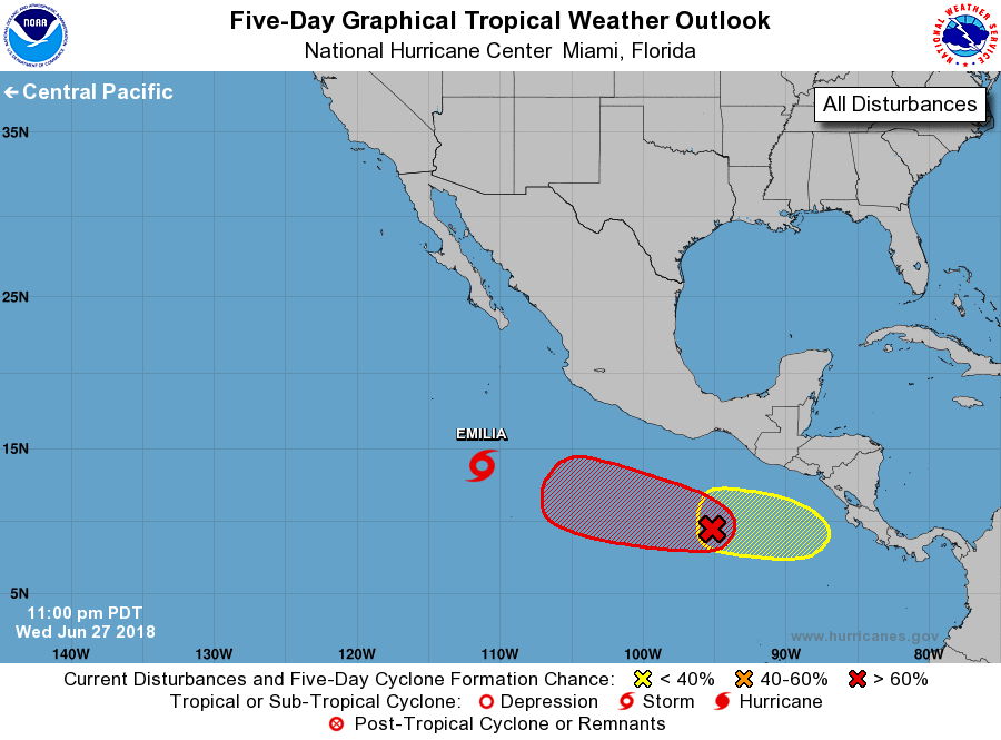
For the eastern North Pacific...east of 140 degrees west longitude:
The National Hurricane Center is issuing advisories on Tropical
Depression Six-E, located several hundred miles south of the
southern tip of the Baja California peninsula.
1. A large area of cloudiness and showers south of the Gulf of
Tehuantepec is associated with a westward-moving tropical wave.
Environmental conditions are forecast to be conducive for
development of this system over the next several days, and a
tropical depression is expected to form well south of the coast of
Mexico by this weekend.
* Formation chance through 48 hours...medium...50 percent.
* Formation chance through 5 days...high...90 percent.
2. Another tropical wave is forecast to move over southern Central
America on Thursday, and then move into the far eastern Pacific by
late Friday. Environmental conditions should support some
development early next week south of Central America while the
system moves westward to west-northwestward.
* Formation chance through 48 hours...low...near 0 percent.
* Formation chance through 5 days...low...30 percent.
Public Advisories on Tropical Depression Six-E are issued under
WMO header WTPZ31 KNHC and under AWIPS header MIATCPEP1.
Forecast/Advisories on Tropical Depression Six-E are issued
under WMO header WTPZ21 KNHC and under AWIPS header MIATCMEP1.
Forecaster Stewart