ZCZC MIATWOAT ALL
TTAA00 KNHC DDHHMM
Tropical Weather Outlook
NWS National Hurricane Center Miami FL
800 PM EDT Mon Jun 27 2022
For the North Atlantic...Caribbean Sea and the Gulf of Mexico:
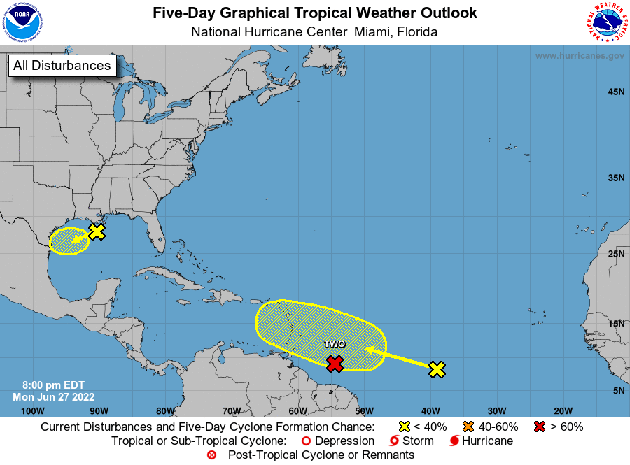
East of the Windward Islands:
The National Hurricane Center is issuing advisories on Potential
Tropical Cyclone Two, located several hundred miles east of the
southern Windward Islands. Conditions appear conducive for
development, and the disturbance will likely become a tropical storm
during the next several days before reaching the southern Windward
Islands or while moving westward across the southern Caribbean Sea.
* Formation chance through 48 hours...high...70 percent.
* Formation chance through 5 days...high...90 percent.
1. Northern Gulf of Mexico:
Disorganized showers and thunderstorms over the north-central Gulf
of Mexico are associated with a trough of low pressure. Some slow
development of this system is possible while it moves
west-southwestward at about 10 mph and approaches the coasts of
southern Texas and northeastern Mexico during the next few days.
* Formation chance through 48 hours...low...10 percent.
* Formation chance through 5 days...low...20 percent.
2. Central Tropical Atlantic:
A tropical wave located several hundred miles southwest of the Cabo
Verde Islands is producing disorganized showers and thunderstorms.
Environmental conditions could become conducive for some gradual
development later this week while the system moves west-
northwestward at around 15 mph over the central tropical Atlantic.
* Formation chance through 48 hours...low...near 0 percent.
* Formation chance through 5 days...low...20 percent.
Public Advisories on Potential Tropical Cyclone Two are issued
under WMO header WTNT32 KNHC and under AWIPS header MIATCPAT2.
Forecast/Advisories on Potential Tropical Cyclone Two are issued
under WMO header WTNT22 KNHC and under AWIPS header MIATCMAT2.
Forecaster Reinhart