ZCZC MIATWOAT ALL
TTAA00 KNHC DDHHMM
Tropical Weather Outlook
NWS National Hurricane Center Miami FL
100 PM EST Mon Nov 9 2020
For the North Atlantic...Caribbean Sea and the Gulf of Mexico:
The National Hurricane Center is issuing advisories on Tropical
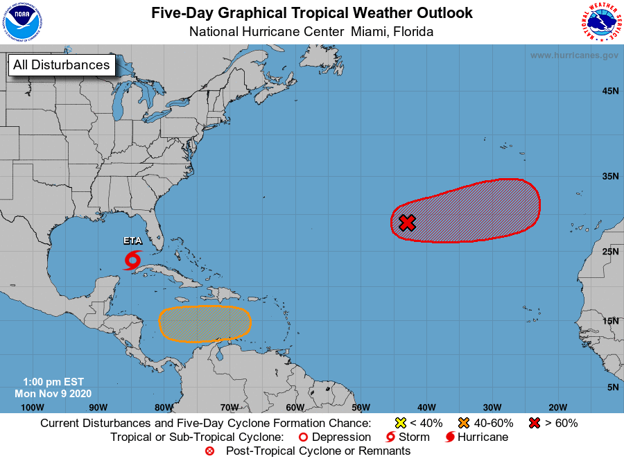
Storm Eta, located over the southeastern Gulf of Mexico.
1. Shower and thunderstorm activity associated with a low pressure
system located several hundred miles southwest of the Azores has
increased and become better organized during the past several hours.
Satellite-derived wind data earlier this morning suggested that the
system had not yet become distinct from a frontal boundary in the
area, however, it will likely become non-frontal soon. The satellite
data also indicated that the system is already producing gale-force
winds. Additional development is expected, and a tropical or
subtropical storm will likely form during the next day or two while
the system moves eastward or east-northeastward over the
northeastern Atlantic Ocean.
* Formation chance through 48 hours...high...70 percent.
* Formation chance through 5 days...high...80 percent.
2. A tropical wave is forecast to move over the central Caribbean Sea,
where an area of low pressure could form in a couple of days.
Environmental conditions are forecast to be conducive for
development, and a tropical depression could form late this week
or over the weekend while the system moves slowly westward.
* Formation chance through 48 hours...low...near 0 percent.
* Formation chance through 5 days...medium...50 percent.
Additional information on the central Atlantic gale area can be
found in High Seas Forecasts issued by the National Weather
Service...under AWIPS header NFDHSFAT1 and WMO header FZNT01 KWBC.
Forecaster Zelinsky