000
AXPZ20 KNHC 170243
TWDEP

Tropical Weather Discussion
NWS National Hurricane Center Miami FL
0405 UTC Tue Nov 17 2026

Tropical Weather Discussion for the eastern Pacific Ocean from
03.4S to 30N, east of 120W including the Gulf of California, and
from the Equator to 30N, between 120W and 140W. The following
information is based on satellite imagery, weather observations,
radar, and meteorological analysis.

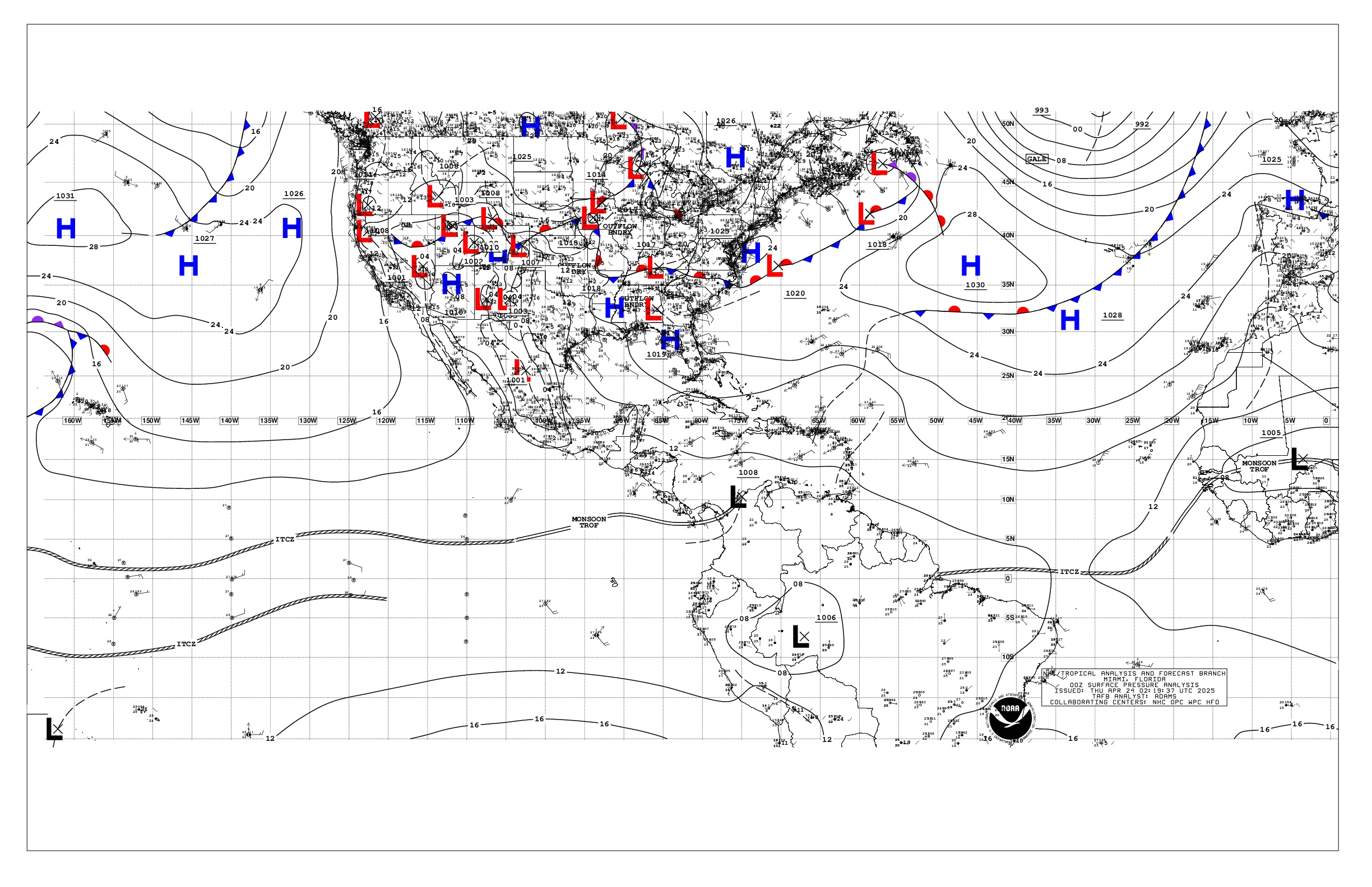
Based on 0000 UTC surface analysis and satellite imagery through
0230 UTC.

...SPECIAL FEATURES...

Gulf of Tehuantepec Gale Warning: The combination between strong
high pressure surging southward over eastern Mexico behind a
stationary front and relatively lower pressure south of
is resulting in near gale north to northeast winds in the Gulf
of Tehuantepec. These winds are forecast to increase to gale
force by early Tue and prevail through Thu night. Seas are
expected to build to 12 to 16 ft with these winds through Wed.
Afterward, north to northeast winds in the Gulf will continue at
fresh to strong speeds through the end of the week, with seas
slowly subsiding.

Significant NW Swell Event: A series of northwest swell sets
will continue to impact much of the open waters for the next
several days associated with the passage of several cold fronts.
A cold front is analyzed from 30N122W to 19N140W. Recent
altimeter satellite data passes indicate seas of 12 to 16 ft
northwest of the cold front. Seas of 8 to 12 ft extend past the
equator west of 100W. Wave periods of 14 to 19 seconds are west
of 105W, and periods of 13 to 16 seconds are east of 100W. These
seas will spread southeastward and start subsiding below 12 ft
by Thu morning. The next cold front will lead to another
northwest swell event beginning around midweek.

Please read the latest NHC High Seas Forecast at website:
https://www.hurricanes.gov/text/HSFEP2.shtml for more details.

...INTERTROPICAL CONVERGENCE ZONE/MONSOON TROUGH...

The monsoon trough extends from 09N84W to 05N95W. The ITCZ
continues from that point to 02N140W. Scattered moderate to
strong convection is S of 09N and W of 126W.

...OFFSHORE WATERS WITHIN 250 NM OF MEXICO...

Please refer to the Special Features section above for details on
a series of significant northwest swell sets and on the Gale
Warning for Gulf of Tehuantepec.

Surface ridging is across the Baja California offshore waters,
generally supporting light to gentle north-northwest winds while
decaying long period northwest swell is supporting rough seas of
8 to 14 ft extending as far south as Michoacan adjacent waters.
Seas of 5 to 7 ft are over the remainder of the offshore waters of
southwestern Mexico. Elsewhere, in the Gulf of California,
gentle winds and 1 to 3 ft seas prevail.

For the forecast, strong to near gale north to northeast winds
will prevail in the Gulf of Tehuantepec tonight before
strengthening to gale-force early on Tue. These gale-force winds
are expected to pulse through much of the week. Seas of 12 to 16
ft are expected with these winds Tue through Wed. Elsewhere,
very rough seas of 12 to 15 ft in northwest swell will expand
southeastward offshore of Baja California, with the leading edge
of the swell set producing seas of 7 to 11 ft near the
Revillagigedo through Thu. Seas of 8 to 10 ft are forecast to
extend offshore of southwestern Mexico over the next several
days. A cold front is expected to be followed by fresh to
strong northerly winds and very rough seas offshore of Baja
California north of Cabo San Lazaro through Wed.

...OFFSHORE WATERS WITHIN 250 NM OF CENTRAL AMERICA, COLOMBIA,
AND WITHIN 750 NM OF ECUADOR...

Fresh northeast to east gap winds are ongoing in the Gulf of
Papagayo with 6 ft seas. Otherwise, moderate or weaker winds and
moderate seas in mixed long-period southwest and northwest swell
remain over the regional waters.

For the forecast, the fresh northeast to east gap winds in the Gulf
of Papagayo will pulse to strong speeds at night and into the
early afternoons through the rest of the week. Rough seas are
expected to accompany these winds. Elsewhere, moderate north
winds will pulse in the Gulf of Panama this week. Rough seas in
north swell may develop well offshore of Guatemala by Wed,
prompted by gale-force winds in the Gulf of Tehuantepec.
Elsewhere, a set of northwest swell may build seas to 8 ft or
greater south-southwest of the Galapagos Islands Wed through Thu
night.

...REMAINDER OF THE AREA...

Please refer to the Special Features section above for details on
a significant swell event that is impacting a good portion of
the area this week.

Recent scatterometer data passes indicate fresh to near gale-
force north to northeast winds northwest of the cold front that
extends from 30N122W to 19N140W. Recent altimeter satellite data
passes reveal seas of 12 to 16 ft to the northwest of the front.
A significant northwest to north swell is occurring with this
front as described above under Special Features. Moderate or
weaker winds prevail across the remainder of the waters east of
about 120W.

For the forecast, a series of northwest swell sets will continue
to impact much of the open waters for the next several days
associated with the passage of several cold fronts. These seas
will spread southeastward through midweek before subsiding. Another
cold front will usher in a new set of long-period northwest swell
and fresh to strong north to northeast winds over the northern
waters beginning Wed afternoon.

$$
ERA


 NHC on Facebook
 NHC on X
 NHC on YouTube
 NHC Blog: