
NOAA'S NATIONAL WEATHER
SERVICE TO CONTINUE
EXISTING TRACK MAP FOR
TROPICAL CYCLONES
NOAA's National Hurricane Center will continue to use its existing track map for hurricanes, tropical storms and tropical depressions during the 2005 Atlantic Hurricane Season. Results of a recent online survey on proposed changes to the track map show the majority of respondents prefer to maintain the current format.
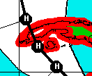
Chart 1 |
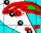
Chart 2 |
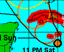
Chart 3 |
Of the nearly 1,000 survey participants, 63 percent favored the existing track map (Chart 1 on the survey), consisting of forecast points for the center of the storm at various times, a line connecting the points, watches/warnings and a white-colored cone indicating the potential track area.
Chart 2 resembled Chart 1, but did not include the line for the projected path. This option attracted the fewest respondents (14 percent).
The third and final chart provided the potential forecast location, as displayed by colored circles indicating the margin of error, and was preferred by 23 percent of the participants.
For the 2005 hurricane season, NOAA's National Hurricane Center will provide a more convenient presentation of all graphical forecast products for each storm on its web site: http://www.nhc.noaa.gov.
Users are encouraged to use the full suite of National Hurricane Center products in order to make informed decisions and to listen to local authorities when severe weather threatens.
Experimental graphics and text products indicating the probability of winds of 39, 58 and 74 mph (34, 50, and 64 knots, respectively) also will be available this year. Feedback will be solicited under the "Top News of the Day" on the National Hurricane Center's Web site this summer. Those responses will determine whether this product becomes fully operational for the 2006 hurricane season.
Media contact:
Chris Vaccaro
NOAA's National Weather Service
301-713-0622