ZCZC MIATWOEP ALL
TTAA00 KNHC DDHHMM
Tropical Weather Outlook
NWS National Hurricane Center Miami FL
1100 AM PDT Mon Jun 13 2022
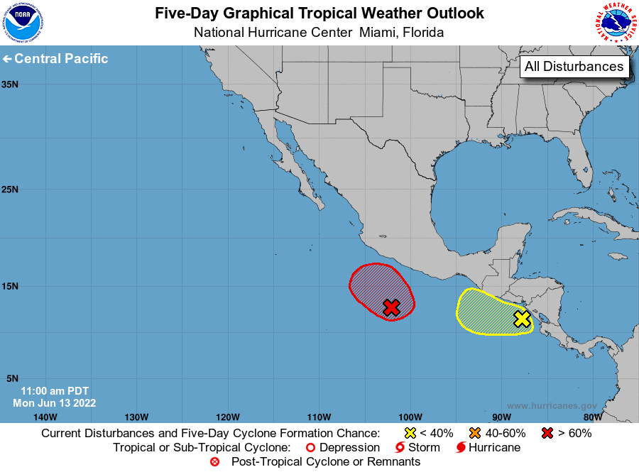
For the eastern North Pacific...east of 140 degrees west longitude:
1. Off the coast of southwestern Mexico:
A broad area of low pressure located a few hundred miles south of
the southwestern coast of Mexico continues to produce a large area
of showers and thunderstorms. This activity has become a bit more
concentrated today, and environmental conditions appear conducive
for additional development. A tropical depression is expected to
form during the next day or so while the system moves slowly
northwestward off the southwestern coast of Mexico. Additional
information on this system, including gale warnings, can be found in
high seas forecasts issued by the National Weather Service.
* Formation chance through 48 hours...high...90 percent.
* Formation chance through 5 days...high...90 percent.
2. Off the coast of Central America:
A trough of low pressure located around a hundred miles southwest
of the coast of Nicaragua is producing a disorganized area of
showers and thunderstorms. This activity has changed little in
organization today, but some additional development of this system
is possible over the next several days as long as it remains
offshore, moving slowly northwestward near the coast of Central
America and southern Mexico. Environmental conditions are forecast
to become less conducive for development by the end of this week.
Regardless of development, locally heavy rains will be possible
across portions of Nicaragua, El Salvador, Guatemala, and Southern
Mexico through the week.
* Formation chance through 48 hours...low...20 percent.
* Formation chance through 5 days...low...30 percent.
High Seas Forecasts issued by the National Weather Service
can be found under AWIPS header NFDHSFEPI, WMO header FZPN02
KWBC, and on the web at ocean.weather.gov/shtml/NFDHSFEPI.php
Forecaster Papin