Skip Navigation Links
NOAA NOAA United States Department of Commerce

NHC Graphical Outlook Archive


« Earliest Available         ‹ Earlier         Later ›         Latest Available »
GIS Shapefiles
Central Pacific Eastern Pacific Atlantic

View 2-Day Graphical Tropical Weather Outlook
Click for Atlantic Click for Atlantic

Tropical Weather Outlook Text

ZCZC MIATWOEP ALL
TTAA00 KNHC DDHHMM

Tropical Weather Outlook
NWS National Hurricane Center Miami FL
500 PM PDT Fri Jun 10 2022

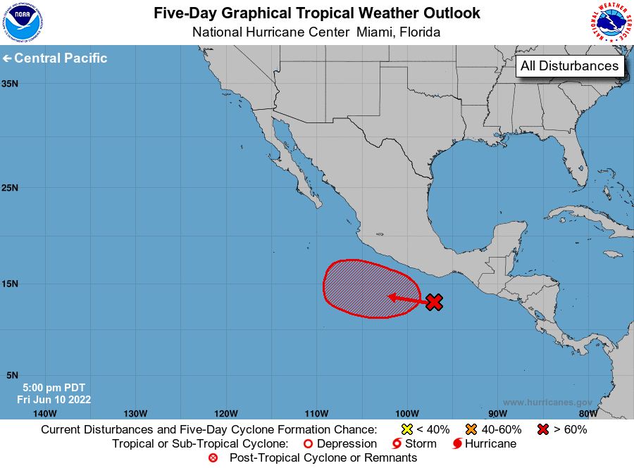
For the eastern North Pacific...east of 140 degrees west longitude:

1. Off the coast of southwestern Mexico:
Shower activity associated with a broad low pressure area located a 
couple hundred miles southwest of the Gulf of Tehuantepec has become 
a little better organized since yesterday. Environmental conditions 
are expected to be conducive for continued gradual development of 
this system, and a tropical depression is likely to form early next 
week while the system meanders off the southwestern coast of Mexico.
* Formation chance through 48 hours...low...30 percent.
* Formation chance through 5 days...high...80 percent.

Forecaster Beven/Bucci


List of Atlantic Outlooks (May 2023 - present)
List of East Pacific Outlooks (May 2023 - present)
List of Central Pacific Outlooks (May 2023 - present)
List of Atlantic Outlooks (July 2014 - April 2023)
List of East Pacific Outlooks (July 2014 - April 2023)
List of Central Pacific Outlooks (June 2019 - April 2023)
List of Atlantic Outlooks (June 2009 - June 2014)
List of East Pacific Outlooks (June 2009 - June 2014)