ZCZC MIATWOEP ALL
TTAA00 KNHC DDHHMM
Tropical Weather Outlook
NWS National Hurricane Center Miami FL
500 PM PDT Mon Aug 2 2021
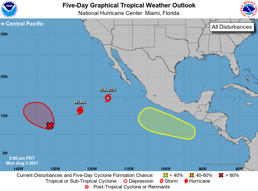
For the eastern North Pacific...east of 140 degrees west longitude:
The National Hurricane Center is issuing advisories on Hurricane
Hilda, located more than 950 miles west-southwest of the southern
tip of the Baja California peninsula, and on Tropical Storm Ignacio,
located more than 400 miles southwest of the southern tip of the
Baja California peninsula.
1. A low pressure system associated with the remnants of Tropical
Depression Nine-E is located more than 1500 miles west-southwest of
the southern tip of the Baja California peninsula. The associated
shower activity continues to show signs of organization, but
satellite-derived wind data indicate the low-level circulation is
still somewhat elongated. Environmental conditions are expected to
remain conducive for continued development early this week, and a
tropical depression is likely to form during the next day or so
while the system moves west-northwestward to northwestward at 5 to
10 mph. By late Thursday, the system is forecast to move over
cooler waters and further development is not expected.
* Formation chance through 48 hours...high...70 percent.
* Formation chance through 5 days...high...70 percent.
2. An area of low pressure is expected to develop a few hundred miles
south of the southern coast of Mexico late this week. Environmental
conditions are forecast to be conducive for gradual development
thereafter while the system remains offshore and moves
west-northwestward at 10 to 15 mph, roughly parallel to the coast of
southwestern Mexico.
* Formation chance through 48 hours...low...near 0 percent.
* Formation chance through 5 days...low...20 percent.
Public Advisories on Tropical Storm Ignacio are issued under WMO
header WTPZ35 KNHC and under AWIPS header MIATCPEP5.
Forecast/Advisories on Tropical Storm Ignacio are issued under
WMO header WTPZ25 KNHC and under AWIPS header MIATCMEP5.
Forecaster Reinhart/Pasch