ZCZC MIATWOEP ALL
TTAA00 KNHC DDHHMM
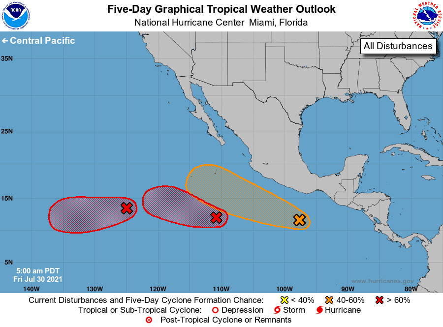
Tropical Weather Outlook
NWS National Hurricane Center Miami FL
500 AM PDT Fri Jul 30 2021
For the eastern North Pacific...east of 140 degrees west longitude:
1. Showers and thunderstorms continue to show signs of organization in
association with an elongated area of low pressure located about 650
miles southwest of the coast of southwestern Mexico. Environmental
conditions are conducive for development, and a tropical depression
or tropical storm is expected to form later today or Saturday while
the system moves west-northwestward at 10 to 15 mph. For more
information on this system, please see High Seas forecasts issued by
the NOAA Tropical Analysis and Forecast Branch.
* Formation chance through 48 hours...high...90 percent.
* Formation chance through 5 days...high...90 percent.
2. Showers and thunderstorms have changed little overnight in
association with an area of low pressure located about 1300 miles
southwest of the southern tip of the Baja California peninsula.
Upper-level winds are expected to become more conducive for
development during the next day or two, and a tropical depression is
expected to form over the weekend while the system moves generally
westward at 5 to 10 mph.
* Formation chance through 48 hours...high...80 percent.
* Formation chance through 5 days...high...90 percent.
3. Disorganized showers and thunderstorms located a few hundred miles
off the coast of southern Mexico are associated with a trough of low
pressure. Gradual development of this system is expected during
the next several days, and it could become a tropical depression
early next week while it moves west-northwestward at 10 to 15 mph.
* Formation chance through 48 hours...low...30 percent.
* Formation chance through 5 days...medium...60 percent.
High Seas Forecasts issued by the National Weather Service can be
found under AWIPS header NFDHSFEPI, WMO header FZPN02 KWBC, and on
the web at ocean.weather.gov/shtml/NFDHSFEPI.php
Forecaster Cangialosi