Skip Navigation Links
NOAA NOAA United States Department of Commerce

NHC Graphical Outlook Archive


« Earliest Available         ‹ Earlier         Later ›         Latest Available »
GIS Shapefiles
Central Pacific Eastern Pacific Atlantic

View 2-Day Graphical Tropical Weather Outlook
Click for Atlantic Click for Atlantic

Tropical Weather Outlook Text

ZCZC MIATWOEP ALL
TTAA00 KNHC DDHHMM

Tropical Weather Outlook
NWS National Hurricane Center Miami FL
500 PM PDT Sun Sep 27 2020

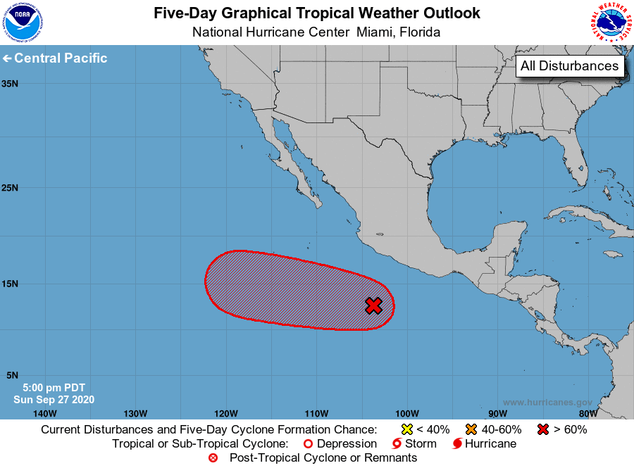
For the eastern North Pacific...east of 140 degrees west longitude:

1. A well-defined low pressure system located a few hundred miles south 
of the southwestern coast of Mexico is producing a large area of 
disorganized cloudiness and thunderstorms.  The disturbance is 
forecast to move generally westward for the next several days, and 
environmental conditions are expected to gradually become more 
conducive for a tropical depression to form around midweek.
* Formation chance through 48 hours...medium...40 percent.
* Formation chance through 5 days...high...90 percent.

Forecaster Stewart


List of Atlantic Outlooks (May 2023 - present)
List of East Pacific Outlooks (May 2023 - present)
List of Central Pacific Outlooks (May 2023 - present)
List of Atlantic Outlooks (July 2014 - April 2023)
List of East Pacific Outlooks (July 2014 - April 2023)
List of Central Pacific Outlooks (June 2019 - April 2023)
List of Atlantic Outlooks (June 2009 - June 2014)
List of East Pacific Outlooks (June 2009 - June 2014)